Ursuia, Mountain peak in Hasparren, France.
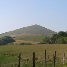
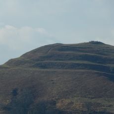
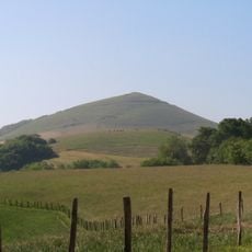
Ursuia is a rounded mountain of 681 metres between Hasparren and Macaye in the Labourd, its summit gently domed rather than pointed. Subtle ridges and folds run down its flanks, and faint lines that may be paths or field boundaries cross the lower slopes. A green hillside with scattered trees and a hedgerow lies below the mountain.
Ursuia was a strategic high point for the two neighbouring towns, Hasparren and Macaye, and several protohistoric forts known as gaztelu zahar were built on its slopes. The mountain's name is linked to its many springs, probably from an old form *Urtzun(a) based on ur, 'water'.
The name Ursuia likely comes from an old form *Urtzun(a), derived from ur, 'water', a reference to the mountain's many springs; the ending -uia, an erosion of -una, recurs in names around Hasparren such as Zalduia and Haltzuia. The neighbourhood of Ursuia on the slopes, sheltered by the Mokorreta spur, carries the same name.
Several marked trails lead to the summit from nearby towns like Hasparren, Urcuray, and Cambo-les-Bains, each offering different distances and difficulty levels. Bring sturdy hiking shoes and weather protection, as conditions can shift quickly on the exposed peak.
The summit holds several protohistoric hillforts, called gaztelu zahar in Basque, a sign of the mountain's strategic role between Hasparren and Macaye. The name Ursuia likely comes from an old word for water, ur, referring to the many springs on its slopes.
The community of curious travelers
AroundUs brings together thousands of curated places, local tips, and hidden gems, enriched daily by 92,849 contributors worldwide.