Tama Hills, Hill range in Tokyo and Kanagawa Prefectures, Japan
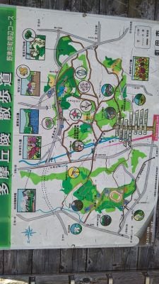
Tama Hills (多摩丘陵, Tama-kyūryō) is a range of low hills covering about 300 km² across southwestern Tokyo and northeastern Kanagawa Prefecture, from the foot of Mount Takao to Yokohama. Its highest point reaches roughly 220 m in southern Hachiōji. The hills are a patchwork of forested slopes, residential suburbs such as Tama New Town and Kohoku New Town, and remaining farmland; the photograph shows a wooded ridge with utility poles and a greenhouse at its base.
Archaeological finds in the region show that settlements existed here during the Jomon period, when hunter-gatherers inhabited these elevated areas. The region later developed into an important transition zone between rural and urban spaces near Tokyo.
The name Tama Hills derives from its position in ancient Tama District, viewed from the Musashi provincial capital at Fuchu as a long ridge running sideways, hence the old name Tama no Yokoyama. That name survives in the Yokoyama Party of the Musashi Seven Parties, Hachioji Yokoyama-shuku, and Musashi-Yokoyama Station. Studio Ghibli's Pom Poko centres on the hills' development, and Mimi wo Sumaseba is set in the Seisekisakuragaoka housing estate built on them.
The hills are crossed by several rail lines, including the Keio Sagamihara Line and Odakyu Tama Line serving Tama New Town, and the Yokohama Municipal Subway Line 3 serving Kohoku New Town. The Tama River marks the northeastern boundary, and the Sagamino plateau lies to the west. Paths in the wooded sections can be muddy after rain.
A museum in the area preserves traditional Japanese farmhouses that were relocated from different regions of the country. These buildings show historical architectural styles and offer insight into earlier rural life in Japan.
The community of curious travelers
AroundUs brings together thousands of curated places, local tips, and hidden gems, enriched daily by 93,297 contributors worldwide.