Mseilha Fort, Medieval fortress in Batroun, Lebanon
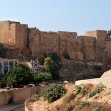
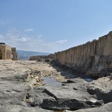
Mseilha is a stone fortress perched on a limestone rock formation above the Al-Jaouz River, featuring thick defensive walls and multiple observation points. The structure integrates directly with the natural terrain, using the elevated position to command views of the surrounding landscape.
The current fort was built around 1624 under Emir Fakhr al-Din II, who ordered Sheikh Abu Nadir al-Khazen to construct it north of Batroun; al-Khazen restored it in 1631. The site had earlier strategic value: after the 551 CE earthquake destroyed the coastal road, a new route bypassed the Ras ash-Shaq'a promontory, and Crusader sources mention a small tower guarding the pass. The existing structure, however, contains no Crusader-era elements.
The name derives from the Arabic musallaha, "fortified place", a diminutive of which is Mseilha. Travellers long mangled it: Henry Maundrell wrote Temseida in the 17th century, and René Dussaud credited the painter Montfort with first recording it correctly as Mseïla in 1897. Inside, a small niche in the southern section faces the qibla, so guards could use it as a prayer space.
Access is via a marked pathway that leads uphill; wear sturdy shoes as the terrain is sometimes steep and rocky. Plan ahead, as there are minimal facilities and shaded areas on site.
The fort appeared on the 25 Lebanese lira banknote issued in 1964, before the civil war. The name Mseilha is a diminutive of the Arabic musallaha, "fortified place". Some 19th-century travelers garbled it: Henry Maundrell wrote Temseida, Burckhardt Kalaat Meszabeha.
The community of curious travelers
AroundUs brings together thousands of curated places, local tips, and hidden gems, enriched daily by 93,650 contributors worldwide.