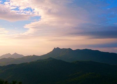
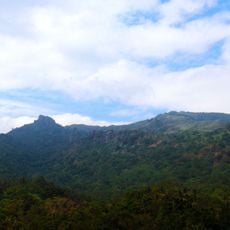
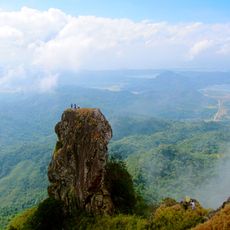
Mount Pico de Loro, Volcanic summit in Cavite province, Philippines.
Mount Pico de Loro is a volcanic summit in Cavite province that rises about 688 meters above sea level. Its most striking feature is a steep rock column near the peak that demands climbing skills and stands out for its dramatic vertical shape.
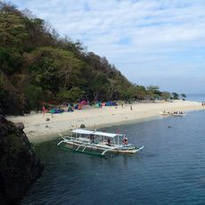
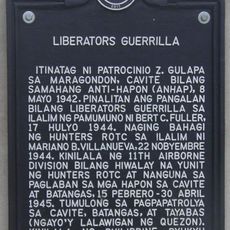
Spanish seafarers named the mountain after its resemblance to a parrot's beak and used it as a landmark for navigation toward Manila. The location later became significant in the Philippine independence movement.
The mountain carries meaning for people interested in Philippine history and independence movements. Visitors come to connect with the past through the landscape and understand its role in local stories.
Visitors need to hire a local guide who knows the best routes and can help with safety concerns. It is wise to arrive early in the day and bring good footwear and water, as the climb is demanding.
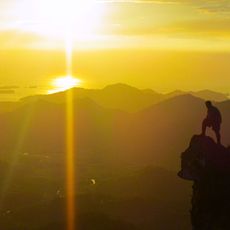
The vertical rock column at the peak is about 15 meters tall and requires technical climbing skills that only experienced mountaineers can handle. On clear days, visitors can see from the summit all the way to the South China Sea and across several provinces.
Location: Maragondon
Location: Nasugbu
Elevation above the sea: 688 m
GPS coordinates: 14.21692,120.64434
Latest update: December 7, 2025 20:24
Fort Hughes
16.9 km
Fort Frank
6.4 km
Paco Church
15.2 km
Bonifacio Trial House
11.9 km
Mount Marami
4.9 km
Nuestra Señora del Buen Suceso de Parañaque
10.8 km
Corregidor Island lighthouse
19.5 km
Casa Hacienda de Naic
17.3 km
Naic Church
17.3 km
Father Modesto de Castro historical marker
17.3 km
Ternate Beach Resort
10.3 km
Phare de Fort Drum
9.9 km
Paniman Beach
7.4 km
Casa Hacienda de Naic historical marker
17.3 km
Andres Bonifacio Trial House historical marker
11.9 km
Emiliano Riego de Dios historical marker
11.8 km
Landing at Nasugbu historical marker
16.4 km
Seaside Beach Resort
16.5 km
Mount Nagpatong historical marker
9.4 km
Bonifacio Shrine and Eco-Tourism Park
9.5 km
The Church of Maragondon historical marker
11.5 km
Corregidor Island lighthouse
19.6 km
Layag Layag Beach
7.7 km
Liberators Guerrilla historical marker
11.7 km
Parrot's Beak
423 m
Silyang Bato
4.9 km
Where Bonifacio was Court-Martialled historical marker
11.9 km
Fuego Beach 2
11.9 kmVisited this place? Tap the stars to rate it and share your experience / photos with the community! Try now! You can cancel it anytime.
Discover hidden gems everywhere you go!
From secret cafés to breathtaking viewpoints, skip the crowded tourist spots and find places that match your style. Our app makes it easy with voice search, smart filtering, route optimization, and insider tips from travelers worldwide. Download now for the complete mobile experience.
A unique approach to discovering new places❞
— Le Figaro
All the places worth exploring❞
— France Info
A tailor-made excursion in just a few clicks❞
— 20 Minutes