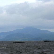
Mount Tagapo, Mountain peak on Talim Island, Philippines.
Mount Tagapo rises about 438 meters above Laguna de Bay and forms the highest point on Talim Island with its distinctive cone shape. Dense forests cover the terrain and define the hiking experience.
The mountain's name comes from the Tagalog word 'taga' meaning to chop, reflecting how local people used the land. The island itself received its name from its blade-like shape visible on maps.
The communities surrounding the mountain have long valued the bamboo forests for traditional crafting practices passed down through generations. These skills remain central to local life and identity today.
The hike from Barangay Janosa takes about 2 hours and follows forest paths to reach the summit. It is wise to register at the local community hall beforehand and arrange a guide for the ascent.
On clear days, visitors from the summit can see the skyline of Metro Manila and several major mountains in the distance. This expansive view rewards the climb with a sense of connection to the wider landscape.
The community of curious travelers
AroundUs brings together thousands of curated places, local tips, and hidden gems, enriched daily by 60,000 contributors worldwide.