Fort Miami

Log in to your account

AroundUs is a community-driven map of interesting places, built by curious explorers like you. It grows with every review, story, and photo you share.
Connect to save your favorite spots, contribute locations, and create personalized routes.
Continue with Google
Continue with Apple
Continue with X
Continue with Facebook
Continue with email
By continuing, you accept our Terms and Conditions and our Privacy Policy
Create an account
Add to collection
Map
Suggest a change
Share

Fort Miami, French colonial fort near St. Joseph, Michigan
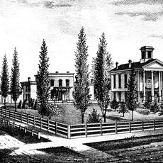
Fort Miami was a French fortification on the banks of the St. Joseph River with earthen walls arranged in a triangular pattern. Deep ditches surrounding the structure formed a defensive system to protect against attack.

René Robert Cavelier founded Fort Miami in November 1679 as a mission and trading post, marking the first European settlement in Michigan. The site later developed into a trading center under different operators.

The trading post served as a meeting place where French, Miami, and Potawatomi peoples exchanged goods and ideas on equal footing. This interaction shaped daily life at the river mouth and created bonds between distinct communities.
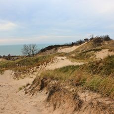
The location at the river mouth provided direct access to Lake Michigan and allowed control of water transportation routes. Visitors should know that the terrain was historically shaped by river bends that shifted over the years.

After the fort's decline, William Burnett established a trading post on the same ground and married Kaukema, daughter of a Potawatomi chief. This union showed how personal relationships shaped the European and native trade networks.

Location: Michigan

GPS coordinates: 42.11090,-86.48230

Latest update: December 11, 2025 18:06

Photos
Around this place
Warren Dunes State Park
United States of America

Warren Dunes State Park

23.6 km
St. Joseph North Pier Inner and Outer Lights
United States of America

St. Joseph North Pier Inner and Outer Lights

1.1 km
Warren Woods State Park
United States of America

Warren Woods State Park

33 km
Grand Mere State Park
United States of America

Grand Mere State Park

14.2 km
Van Buren State Park
United States of America

Van Buren State Park

30.3 km
Moccasin Bluff Site
United States of America

Moccasin Bluff Site

30 km
Fernwood Botanical Garden and Nature Preserve
United States of America

Fernwood Botanical Garden and Nature Preserve

29.6 km
Sandburg House
United States of America

Sandburg House

28.1 km
Shiloh House
United States of America

Shiloh House

4.3 km
Blossomland Bridge
United States of America

Blossomland Bridge

399 m
Dowagiac Woods
United States of America

Dowagiac Woods

29 km
North Point Park
United States of America

North Point Park

29.9 km
Ninth District Lighthouse Depot
United States of America

Ninth District Lighthouse Depot

388 m
Avery Road – Galien River Bridge
United States of America

Avery Road – Galien River Bridge

27 km
Berrien Springs Courthouse
United States of America

Berrien Springs Courthouse

21.6 km
St. Joseph North Pier Outer Light
United States of America

St. Joseph North Pier Outer Light

1.2 km
Old Berrien County Courthouse Complex
United States of America

Old Berrien County Courthouse Complex

21.6 km
Crystal Springs Street–Dowagiac River Bridge
United States of America

Crystal Springs Street–Dowagiac River Bridge

30.8 km
North Watervliet Road – Paw Paw Lake Outlet Bridge
United States of America

North Watervliet Road – Paw Paw Lake Outlet Bridge

22 km
St. Joseph North Pier Inner Light
United States of America

St. Joseph North Pier Inner Light

1.1 km
Fidelity Building
United States of America

Fidelity Building

2.4 km
Wendell P. and Harriet Rounds Robbins House
United States of America

Wendell P. and Harriet Rounds Robbins House

3.2 km
Buchanan North and West Neighborhoods Historic District
United States of America

Buchanan North and West Neighborhoods Historic District

32.9 km
Union Block
United States of America

Union Block

33.2 km
Lions Beach
United States of America

Lions Beach

1.4 km
Old Saint Joseph Neighborhood Historical Marker
United States of America

Old Saint Joseph Neighborhood Historical Marker

1.3 km
CSX St Joseph River Bridge
United States of America

CSX St Joseph River Bridge

171 m
Burnett's Post Historical Marker
United States of America

Burnett's Post Historical Marker

1.7 km
Show the full map
Reviews

Visited this place? Tap the stars to rate it and share your experience / photos with the community! Try now! You can cancel it anytime.

« Fort Miami - French colonial fort near St. Joseph, Michigan » is provided by Around Us (aroundus.com). Images and texts are derived from Wikimedia project under a Creative Commons license. You are allowed to copy, distribute, and modify copies of this page, under the conditions set by the license, as long as this note is clearly visible.

Discover hidden gems everywhere you go!

From secret cafés to breathtaking viewpoints, skip the crowded tourist spots and find places that match your style. Our app makes it easy with voice search, smart filtering, route optimization, and insider tips from travelers worldwide. Download now for the complete mobile experience.

Around Us App Screenshot

A unique approach to discovering new places

Le Figaro

All the places worth exploring

France Info

A tailor-made excursion in just a few clicks

20 Minutes