Blossomland Bridge

Log in to your account

AroundUs is a community-driven map of interesting places, built by curious explorers like you. It grows with every review, story, and photo you share.
Connect to save your favorite spots, contribute locations, and create personalized routes.
Continue with Google
Continue with Apple
Continue with X
Continue with Facebook
Continue with email
By continuing, you accept our Terms and Conditions and our Privacy Policy
Create an account
Add to collection
Map
Suggest a change
Share

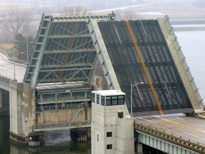
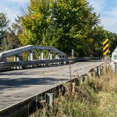
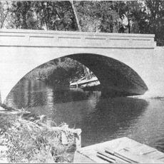
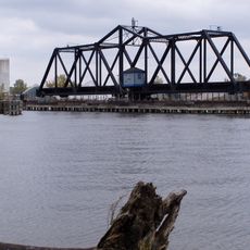
Blossomland Bridge, Bascule bridge in St. Joseph, US.

Blossomland Bridge is a bascule bridge crossing the St. Joseph River with seven structural sections. The design combines steel deck plate-girders with concrete piers to support both the main span and approach roads.

The Michigan State Highway Department completed this bridge in 1948 after construction delays during World War II. It was built to carry M-63 across the river and became a key part of the region's road network.

The National Register of Historic Places recognized this bridge in 1999 for its engineering design, particularly its Scherzer rolling-lift mechanism.

The bridge opens seasonally with more frequent access during warm months and less predictable timing in winter. Plan your crossing carefully as scheduling can vary depending on river traffic and weather conditions.

At its inauguration, this structure stood as the longest bridge built by the Michigan State Highway Department, carrying M-63 across the water.

Location: St. Joseph

GPS coordinates: 42.11220,-86.47780

Latest update: December 14, 2025 16:47

Photos
Around this place
Warren Dunes State Park
United States of America

Warren Dunes State Park

23.9 km
St. Joseph North Pier Inner and Outer Lights
United States of America

St. Joseph North Pier Inner and Outer Lights

1.4 km
Grand Mere State Park
United States of America

Grand Mere State Park

14.5 km
Van Buren State Park
United States of America

Van Buren State Park

30 km
Fort Miami
United States of America

Fort Miami

399 m
Moccasin Bluff Site
United States of America

Moccasin Bluff Site

30 km
Fernwood Botanical Garden and Nature Preserve
United States of America

Fernwood Botanical Garden and Nature Preserve

29.6 km
Sandburg House
United States of America

Sandburg House

28.4 km
Shiloh House
United States of America

Shiloh House

3.9 km
Dowagiac Woods
United States of America

Dowagiac Woods

28.8 km
North Point Park
United States of America

North Point Park

29.6 km
Ninth District Lighthouse Depot
United States of America

Ninth District Lighthouse Depot

602 m
Avery Road – Galien River Bridge
United States of America

Avery Road – Galien River Bridge

27.2 km
Berrien Springs Courthouse
United States of America

Berrien Springs Courthouse

21.5 km
St. Joseph North Pier Outer Light
United States of America

St. Joseph North Pier Outer Light

1.5 km
Old Berrien County Courthouse Complex
United States of America

Old Berrien County Courthouse Complex

21.5 km
Crystal Springs Street–Dowagiac River Bridge
United States of America

Crystal Springs Street–Dowagiac River Bridge

30.6 km
North Watervliet Road – Paw Paw Lake Outlet Bridge
United States of America

North Watervliet Road – Paw Paw Lake Outlet Bridge

21.6 km
St. Joseph North Pier Inner Light
United States of America

St. Joseph North Pier Inner Light

1.4 km
Fidelity Building
United States of America

Fidelity Building

2 km
Criffield-Whiteley House
United States of America

Criffield-Whiteley House

33 km
Wendell P. and Harriet Rounds Robbins House
United States of America

Wendell P. and Harriet Rounds Robbins House

2.9 km
Buchanan North and West Neighborhoods Historic District
United States of America

Buchanan North and West Neighborhoods Historic District

33 km
Union Block
United States of America

Union Block

33.2 km
Lions Beach
United States of America

Lions Beach

1.8 km
Old Saint Joseph Neighborhood Historical Marker
United States of America

Old Saint Joseph Neighborhood Historical Marker

1.6 km
CSX St Joseph River Bridge
United States of America

CSX St Joseph River Bridge

417 m
Burnett's Post Historical Marker
United States of America

Burnett's Post Historical Marker

1.7 km
Show the full map
Reviews

Visited this place? Tap the stars to rate it and share your experience / photos with the community! Try now! You can cancel it anytime.

« Blossomland Bridge - Bascule bridge in St. Joseph, US » is provided by Around Us (aroundus.com). Images and texts are derived from Wikimedia project under a Creative Commons license. You are allowed to copy, distribute, and modify copies of this page, under the conditions set by the license, as long as this note is clearly visible.

Discover hidden gems everywhere you go!

From secret cafés to breathtaking viewpoints, skip the crowded tourist spots and find places that match your style. Our app makes it easy with voice search, smart filtering, route optimization, and insider tips from travelers worldwide. Download now for the complete mobile experience.

Around Us App Screenshot

A unique approach to discovering new places

Le Figaro

All the places worth exploring

France Info

A tailor-made excursion in just a few clicks

20 Minutes