Enable Location

We need your location to show you interesting places around you

Discover nearby places

Find interesting locations and hidden gems around you

Precise directions

Get accurate directions and distances to places

Your location is never shared with other users. It's only used when you tap the location button.

Lincoln Highway

Log in to your account

Start exploring — it's free

Trusted by 62,469 travelers worldwide

Continue with Google
Continue with Apple
or

We will send you a code to connect

By continuing, you accept our Terms and Conditions and our Privacy Policy

Check your inbox

We've sent a pincode in your inbox. Please enter the code below.

Lincoln Highway, auto trail in Omaha, Nebraska, USA

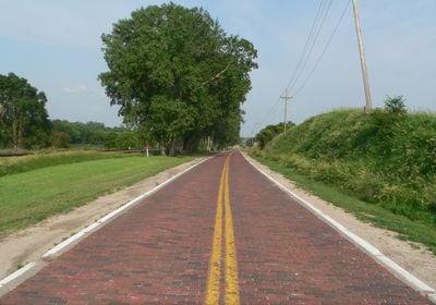
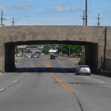
The Lincoln Highway is a historic road in Omaha that served as a transportation route between the eastern and western coasts of the United States. The segment runs approximately 3 miles between North 174th and North 192nd streets and features original brick pavement from the 1920s.

The road was established in 1913 by the Lincoln Highway Association, led by Carl G. Fisher, to create a continuous route from New York to San Francisco. The Omaha to Elkhorn section was paved with bricks in 1920, making automobile travel safer and accelerating the movement of people and goods westward.

The road is named after President Abraham Lincoln and represents the connection between east and west that visitors can experience while traveling through. Local residents and travelers recognize it as a symbol of early automobile culture and the spirit of exploration that shaped the nation.

Visitors can walk along the original section and view the historical markers that were installed in 1976 near North 180th Street. The road is accessible and easy to explore on foot, making it simple for anyone interested in early transportation history to experience the road as it was built.

What makes this section special is that it has remained virtually unchanged since the 1920s, making it one of the few remaining examples of original brick pavement from that era. Very few stretches of the original Lincoln Highway have preserved this level of authenticity, making this segment a rare window into early automobile travel.

The community of curious travelers

AroundUs brings together thousands of curated places, local tips, and hidden gems, enriched daily by 60,000 contributors worldwide.

Start exploring
Location
Inception
1913
Part of
Lincoln Highway
GPS coordinates
41.27167,-96.20194
Latest update
February 9, 2026 08:23
Around this place
Show the full map
« Lincoln Highway - auto trail in Omaha, Nebraska, USA » is provided by Around Us (aroundus.com). Images and texts are derived from Wikimedia project under a Creative Commons license. You are allowed to copy, distribute, and modify copies of this page, under the conditions set by the license, as long as this note is clearly visible.

Discover hidden gems everywhere you go!

From secret cafés to breathtaking viewpoints, skip the crowded tourist spots and find places that match your style. Our app makes it easy with voice search, smart filtering, route optimization, and insider tips from travelers worldwide. Download now for the complete mobile experience.

Around Us App Screenshot

A unique approach to discovering new places

Le Figaro

All the places worth exploring

France Info

A tailor-made excursion in just a few clicks

20 Minutes

Around Us
Travel Guide & Maps
Download

Send to your phone

QR Code
1

Open the camera app on your mobile.

2

Point at the QR code with your camera. A notification will appear.

3

Tap the notification to open the link.