Enable Location

We need your location to show you interesting places around you

Discover nearby places

Find interesting locations and hidden gems around you

Precise directions

Get accurate directions and distances to places

Your location is never shared with other users. It's only used when you tap the location button.

Blue Hills Parkway

Log in to your account

Start exploring — it's free

Trusted by 62,589 travelers worldwide

Continue with Google
Continue with Apple
or

We will send you a code to connect

By continuing, you accept our Terms and Conditions and our Privacy Policy

Check your inbox

We've sent a pincode in your inbox. Please enter the code below.

Blue Hills Parkway, road in Massachusetts, USA

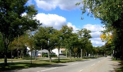
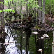
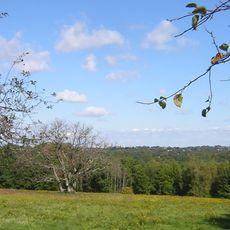
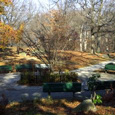
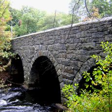
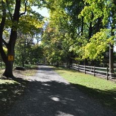
Blue Hills Parkway is a historic road stretching about one and a half miles through residential neighborhoods in Milton and Boston, lined with mature trees on both sides. The road crosses the Neponset River via a granite-arched bridge with three spans and leads south through tree-covered sections before ending at a rotary intersection near Canton Avenue.

Designed in 1893 by landscape architect Charles Eliot, the road was constructed between 1898 and 1903, with the Neponset River bridge completed between 1901 and 1903. It was added to the National Register of Historic Places in 2003 as part of Boston's historic park and road system.

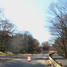
The road has sidewalks on both sides suitable for walking and provides adequate lanes for vehicle traffic throughout. Traffic tends to be heavier during peak hours, especially near the northern end at Mattapan Square, so visiting during quieter times offers a more pleasant experience.

The road features a granite mile marker dating to around 1823 that remains visible today, serving as a reminder of the area's earliest boundary markings. This overlooked landmark is a rare example of early surveying practices that most visitors pass without noticing.

The community of curious travelers

AroundUs brings together thousands of curated places, local tips, and hidden gems, enriched daily by 60,000 contributors worldwide.

Start exploring
Location
Location
GPS coordinates
42.25583,-71.09389
Latest update
February 9, 2026 08:21
Around this place
G. H. Bent Company
United States of America

G. H. Bent Company

2.4 km
Dorchester-Milton Lower Mills Industrial District
United States of America

Dorchester-Milton Lower Mills Industrial District

2.7 km
George Wright Golf Course
United States of America

George Wright Golf Course

3.5 km
Stony Brook Reservation
United States of America

Stony Brook Reservation

3.3 km
Eustis Estate
United States of America

Eustis Estate

2.9 km
Captain Robert Bennet Forbes House
United States of America

Captain Robert Bennet Forbes House

2.6 km
Boston Consumptives Hospital
United States of America

Boston Consumptives Hospital

2.1 km
Governor Hutchinson's Field
United States of America

Governor Hutchinson's Field

2.6 km
Fairview Cemetery
United States of America

Fairview Cemetery

4 km
Blue Hills Reservation Parkways
United States of America

Blue Hills Reservation Parkways

4 km
Mount Hope Cemetery
United States of America

Mount Hope Cemetery

3.2 km
Dorchester Park
United States of America

Dorchester Park

3.2 km
Paul's Bridge
United States of America

Paul's Bridge

3.4 km
Gov. Thomas Hutchinson's Ha-ha
United States of America

Gov. Thomas Hutchinson's Ha-ha

2.4 km
Truman Parkway
United States of America

Truman Parkway

1.5 km
Belcher-Rowe House
United States of America

Belcher-Rowe House

3.7 km
First Congregational Church of Hyde Park
United States of America

First Congregational Church of Hyde Park

2.2 km
Almont Apartments
United States of America

Almont Apartments

2.1 km
Milton Hill Historic District
United States of America

Milton Hill Historic District

2.5 km
Wakefield Estate
United States of America

Wakefield Estate

4.1 km
Dorchester South Burying Ground
United States of America

Dorchester South Burying Ground

3.4 km
Brush Hill Historic District
United States of America

Brush Hill Historic District

1.7 km
Milton Centre Historic District
United States of America

Milton Centre Historic District

1.2 km
Dr. Amos Holbrook House
United States of America

Dr. Amos Holbrook House

2.5 km
Scott's Woods Historic District
United States of America

Scott's Woods Historic District

3.7 km
Walton and Roslin Halls
United States of America

Walton and Roslin Halls

3.9 km
Samuel Edelman Apartments
United States of America

Samuel Edelman Apartments

3.9 km
Suffolk Resolves House
United States of America

Suffolk Resolves House

2.7 km
Show the full map
« Blue Hills Parkway - road in Massachusetts, USA » is provided by Around Us (aroundus.com). Images and texts are derived from Wikimedia project under a Creative Commons license. You are allowed to copy, distribute, and modify copies of this page, under the conditions set by the license, as long as this note is clearly visible.

Discover hidden gems everywhere you go!

From secret cafés to breathtaking viewpoints, skip the crowded tourist spots and find places that match your style. Our app makes it easy with voice search, smart filtering, route optimization, and insider tips from travelers worldwide. Download now for the complete mobile experience.

Around Us App Screenshot

A unique approach to discovering new places

Le Figaro

All the places worth exploring

France Info

A tailor-made excursion in just a few clicks

20 Minutes

Around Us
Travel Guide & Maps
Download

Send to your phone

QR Code
1

Open the camera app on your mobile.

2

Point at the QR code with your camera. A notification will appear.

3

Tap the notification to open the link.