Chest opened
+${chestReward.xp} XP
Explorer
NOUVEAU ×${chestReward.collectible.quantity}
tapez pour fermer
Chest locked

Open chests in the app

Around Us is built for your phone — chests unlock when you walk, explore and capture nearby places.

Enable Location

We need your location to show you interesting places around you

Discover nearby places

Find interesting locations and hidden gems around you

Precise directions

Get accurate directions and distances to places

Your location is never shared with other users. It's only used when you tap the location button.

Tallmadge

Log in to your account

Start exploring — it's free

Trusted by 72,878 travelers worldwide

Continue with Google
Continue with Apple
or

We will send you a code to connect

By continuing, you accept our Terms and Conditions and our Privacy Policy

Check your inbox

We've sent a pincode in your inbox. Please enter the code below.

Discussion Reviews 1 Photos
16.3k Popularity

Tallmadge, city in Ohio

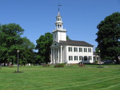
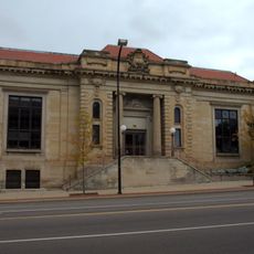
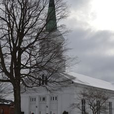
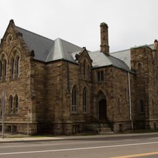
Tallmadge is a city in Summit County, Ohio, sitting partly within Portage County as well. Its center is built around an eight-point traffic circle, with a park, a historic church, and an old town hall arranged around it.

The settlement began in 1807 when David Bacon laid out the town with its distinctive circular plan at the center. The church was completed in 1825 and the town hall in 1859, giving the center the shape it still has today.

The city takes its name from Benjamin Tallmadge, a Revolutionary War officer whom founder David Bacon chose to honor. Today, the central circle is a meeting point for community events, and the church that anchors it still holds regular services.

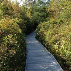
The town center is easy to walk around since the circle and the main buildings are close together. For those who want to go further, there are walking trails in the area, including the Freedom Trail just outside the core.

Tallmadge kept a local ban on alcohol until the early 1990s, decades after the end of national Prohibition. Delanie's Grille was among the first places in town to receive a liquor license after the ban was lifted.

The community of curious travelers

AroundUs brings together thousands of curated places, local tips, and hidden gems, enriched daily by 60,000 contributors worldwide.

Start exploring
Location
Location
Inception
1807
Elevation above the sea
340 m
GPS coordinates
41.09690,-81.42420
Latest update
March 3, 2026 10:14
Around this place
Rubber Bowl
United States of America

Rubber Bowl

6.9 km
InfoCision Stadium – Summa Field
United States of America

InfoCision Stadium – Summa Field

7.5 km
Quaker Square
United States of America

Quaker Square

7.8 km
Akron Art Museum
United States of America

Akron Art Museum

7.9 km
Akron-Summit County Public Library
United States of America

Akron-Summit County Public Library

7.9 km
Mary Campbell Cave
United States of America

Mary Campbell Cave

6.9 km
E. J. Thomas Hall
United States of America

E. J. Thomas Hall

7.9 km
Huntington Tower
United States of America

Huntington Tower

8.1 km
All-America Bridge
United States of America

All-America Bridge

7.4 km
FirstEnergy Stadium-Cub Cadet Field
United States of America

FirstEnergy Stadium-Cub Cadet Field

7.7 km
Goodyear Hall-Ohio Savings and Trust Company
United States of America

Goodyear Hall-Ohio Savings and Trust Company

6 km
Akron Public Library
United States of America

Akron Public Library

7.8 km
Summit County Courthouse
United States of America

Summit County Courthouse

8 km
Tom S. Cooperrider-Kent Bog State Nature Preserve
United States of America

Tom S. Cooperrider-Kent Bog State Nature Preserve

6.9 km
Aaron Ferrey House
United States of America

Aaron Ferrey House

6 km
Eagles Temple
United States of America

Eagles Temple

7.6 km
The Gothic Building
United States of America

The Gothic Building

7.8 km
Kent Jail
United States of America

Kent Jail

7.5 km
Akron Fulton International Airport Administration Building
United States of America

Akron Fulton International Airport Administration Building

6.9 km
East Market Street Church of Christ
United States of America

East Market Street Church of Christ

6.3 km
Francis D. Alling House
United States of America

Francis D. Alling House

619 m
First Congregational Church of Cuyahoga Falls
United States of America

First Congregational Church of Cuyahoga Falls

6.5 km
West Main Street District
United States of America

West Main Street District

8 km
John F. Seiberling Federal Building and United States Courthouse
United States of America

John F. Seiberling Federal Building and United States Courthouse

8 km
St. Paul's Sunday School and Parish House
United States of America

St. Paul's Sunday School and Parish House

7.2 km
Maca Park
United States of America

Maca Park

1.8 km
Matthews Hotel Monument
United States of America

Matthews Hotel Monument

7.8 km
Cascade Locks Park Association
United States of America

Cascade Locks Park Association

7.9 km
Show the full map
Reviews
Share your experience

No review yet

Discussions
Start a discussion...

No discussion yet

« Tallmadge - city in Ohio » is provided by Around Us (aroundus.com). Images and texts are derived from Wikimedia project under a Creative Commons license. You are allowed to copy, distribute, and modify copies of this page, under the conditions set by the license, as long as this note is clearly visible.

Discover hidden gems everywhere you go!

From secret cafés to breathtaking viewpoints, skip the crowded tourist spots and find places that match your style. Our app makes it easy with voice search, smart filtering, route optimization, and insider tips from travelers worldwide. Download now for the complete mobile experience.

Around Us App Screenshot

A unique approach to discovering new places

Le Figaro

All the places worth exploring

France Info

A tailor-made excursion in just a few clicks

20 Minutes

Around Us
Travel Guide & Maps
Download

Send to your phone

QR Code
1

Open the camera app on your mobile.

2

Point at the QR code with your camera. A notification will appear.

3

Tap the notification to open the link.