Enable Location

We need your location to show you interesting places around you

Discover nearby places

Find interesting locations and hidden gems around you

Precise directions

Get accurate directions and distances to places

Your location is never shared with other users. It's only used when you tap the location button.

Delair Bridge

Log in to your account

Start exploring — it's free

Trusted by 66,569 travelers worldwide

Continue with Google
Continue with Apple
or

We will send you a code to connect

By continuing, you accept our Terms and Conditions and our Privacy Policy

Check your inbox

We've sent a pincode in your inbox. Please enter the code below.

Discussion Reviews 1 Photos
6.2k Popularity

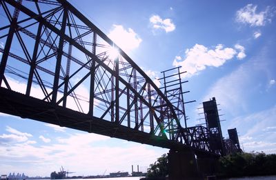
Delair Bridge, Steel railway bridge in Philadelphia, US.

Delair Bridge is a steel railway truss bridge that crosses the Delaware River, linking Philadelphia with Pennsauken Township in New Jersey. It has two fixed steel spans on either side and a vertical lift section at the center that can rise to let river traffic pass below.

The bridge was built in 1896 by the Pennsylvania Railroad as the first railroad crossing over the Delaware River between Philadelphia and New Jersey. The original middle span was replaced in 1958 with a vertical lift section designed to handle the needs of river navigation.

The bridge crosses a stretch of the Delaware River that has long been shaped by industry and rail traffic, and it remains in daily use by freight and passenger trains. From the riverbank, visitors can sometimes watch the center span rise to let a boat pass through.

The bridge is not open to pedestrians and can only be accessed by rail. Good viewing spots along the Delaware riverbank or from nearby road bridges give a clear look at the full structure.

When the center span was replaced in 1958, it was installed as a single prefabricated unit rather than being assembled piece by piece on site. This method meant that both river traffic and rail service could continue with very little interruption during the work.

The community of curious travelers

AroundUs brings together thousands of curated places, local tips, and hidden gems, enriched daily by 60,000 contributors worldwide.

Start exploring
Location
Official opening
1896
Length
1,339.9 m
GPS coordinates
39.98235,-75.06910
Latest update
March 3, 2026 10:09
Around this place
Betsy Ross Bridge
United States of America

Betsy Ross Bridge

448 m
Tacony–Palmyra Bridge
United States of America

Tacony–Palmyra Bridge

4.1 km
SugarHouse Casino
United States of America

SugarHouse Casino

5.7 km
Penn Treaty Park
United States of America

Penn Treaty Park

5.4 km
John Ruan House
United States of America

John Ruan House

3.6 km
Barnegat
United States of America

Barnegat

4.8 km
Carl Mackley Houses
United States of America

Carl Mackley Houses

4.2 km
St. Joseph Pro-Cathedral
United States of America

St. Joseph Pro-Cathedral

4.1 km
Cathedral of the Immaculate Conception
United States of America

Cathedral of the Immaculate Conception

6 km
Green Tree Tavern
United States of America

Green Tree Tavern

5.6 km
Joseph Cooper House
United States of America

Joseph Cooper House

5.1 km
Beatty's Mills Factory Building
United States of America

Beatty's Mills Factory Building

5.1 km
Tacony Music Hall
United States of America

Tacony Music Hall

5.2 km
Burrough-Dover House
United States of America

Burrough-Dover House

4.5 km
Cooper Street Historic District
United States of America

Cooper Street Historic District

6 km
David Wilmot School
United States of America

David Wilmot School

3.6 km
Frankford Friends Meeting House
United States of America

Frankford Friends Meeting House

3.5 km
Wilson Building
United States of America

Wilson Building

5.9 km
Comly Rich House
United States of America

Comly Rich House

3.4 km
Griffith Morgan House
United States of America

Griffith Morgan House

1.9 km
St. Josaphat Ukrainian Catholic Church, Philadelphia
United States of America

St. Josaphat Ukrainian Catholic Church, Philadelphia

5.5 km
William W. Axe School
United States of America

William W. Axe School

3.5 km
David Farragut School
United States of America

David Farragut School

5.7 km
Newton Friends' Meetinghouse
United States of America

Newton Friends' Meetinghouse

5.8 km
Kensington Branch of the Philadelphia YWCA
United States of America

Kensington Branch of the Philadelphia YWCA

5.8 km
Fisher's Lane Bridge
United States of America

Fisher's Lane Bridge

5.2 km
Lithuanian Hall (Philadelphia, Pennsylvania)
United States of America

Lithuanian Hall (Philadelphia, Pennsylvania)

2.8 km
Riverton Historic District
United States of America

Riverton Historic District

5.6 km
Show the full map
Reviews
Share your experience

No review yet

Discussions
Start a discussion...

No discussion yet

« Delair Bridge - Steel railway bridge in Philadelphia, US » is provided by Around Us (aroundus.com). Images and texts are derived from Wikimedia project under a Creative Commons license. You are allowed to copy, distribute, and modify copies of this page, under the conditions set by the license, as long as this note is clearly visible.

Discover hidden gems everywhere you go!

From secret cafés to breathtaking viewpoints, skip the crowded tourist spots and find places that match your style. Our app makes it easy with voice search, smart filtering, route optimization, and insider tips from travelers worldwide. Download now for the complete mobile experience.

Around Us App Screenshot

A unique approach to discovering new places

Le Figaro

All the places worth exploring

France Info

A tailor-made excursion in just a few clicks

20 Minutes

Around Us
Travel Guide & Maps
Download

Send to your phone

QR Code
1

Open the camera app on your mobile.

2

Point at the QR code with your camera. A notification will appear.

3

Tap the notification to open the link.