Enable Location

We need your location to show you interesting places around you

Discover nearby places

Find interesting locations and hidden gems around you

Precise directions

Get accurate directions and distances to places

Your location is never shared with other users. It's only used when you tap the location button.

Betsy Ross Bridge

Log in to your account

Start exploring — it's free

Trusted by 60,664 travelers worldwide

Continue with Google
Continue with Apple
or

We will send you a code to connect

By continuing, you accept our Terms and Conditions and our Privacy Policy

Check your inbox

We've sent a pincode in your inbox. Please enter the code below.

Betsy Ross Bridge

Betsy Ross Bridge, Continuous truss toll bridge in Philadelphia, United States

Description

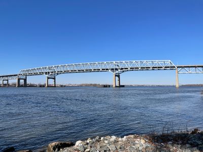
The Betsy Ross Bridge is a toll crossing with a continuous truss design that spans the Delaware River for 2586 meters, linking Philadelphia in Pennsylvania to Pennsauken in New Jersey. It carries six lanes of traffic across the water and serves as part of Route 90, handling vehicles moving between the two states.

History

Construction of this crossing began in 1969 and opened to traffic in the spring of 1976, timed to coincide with the bicentennial of American independence. It emerged during a period when several new river crossings between Pennsylvania and New Jersey were planned to meet growing traffic demand.

Culture

This crossing carries the name of Betsy Ross, a Philadelphia woman credited with sewing the first American flag. It became the first automotive bridge in the United States named after a woman, marking a recognition of her historical role.

Practical

Vehicles heading westbound into Pennsylvania pay a toll, while traffic moving toward New Jersey crosses without charge. The span remains open around the clock for all vehicle types, with electronic payment systems speeding passage through toll collection points.

Did you know?

During construction, headstones from the closed Monument Cemetery were used as riprap to stabilize the shoreline foundations. These historical relics from a graveyard that operated from 1837 until the 1950s became part of the infrastructure supporting the crossing.

Official opening
April 30, 1976
Length
2,586 m
Longest Span
222 m
GPS coordinates
39.98595,-75.06676
Latest update
December 5, 2025 22:30

AroundUs brings together thousands of curated places, local tips, and hidden gems, enriched daily by 60,000 contributors worldwide. Discover all places nearby (Philadelphia County).

Around this place
Frankford Arsenal
United States of America

Frankford Arsenal

2.4 km
Tacony–Palmyra Bridge
United States of America

Tacony–Palmyra Bridge

3.6 km
Delair Bridge
United States of America

Delair Bridge

448 m
John Ruan House
United States of America

John Ruan House

3.4 km
Barnegat
United States of America

Barnegat

5.2 km
Kensington High School
United States of America

Kensington High School

5.1 km
Carl Mackley Houses
United States of America

Carl Mackley Houses

4 km
St. Joseph Pro-Cathedral
United States of America

St. Joseph Pro-Cathedral

4.5 km
Warren G. Harding Middle School
United States of America

Warren G. Harding Middle School

3 km
Philip H. Sheridan School
United States of America

Philip H. Sheridan School

4.3 km
Frances E. Willard School
United States of America

Frances E. Willard School

4.4 km
Conwell Middle Magnet School
United States of America

Conwell Middle Magnet School

4.2 km
James J. Sullivan School
United States of America

James J. Sullivan School

3.3 km
Memphis Street Academy
United States of America

Memphis Street Academy

3.9 km
Francis Hopkinson School
United States of America

Francis Hopkinson School

3.9 km
Burrough-Dover House
United States of America

Burrough-Dover House

4.4 km
John Marshall School
United States of America

John Marshall School

3.7 km
Alternative Middle Years at James Martin School
United States of America

Alternative Middle Years at James Martin School

2.6 km
David Wilmot School
United States of America

David Wilmot School

3.3 km
Thomas Powers School
United States of America

Thomas Powers School

4.6 km
Frankford Friends Meeting House
United States of America

Frankford Friends Meeting House

3.2 km
Richmond School
United States of America

Richmond School

3.7 km
Comly Rich House
United States of America

Comly Rich House

3.1 km
Griffith Morgan House
United States of America

Griffith Morgan House

1.6 km
Bridesburg School
United States of America

Bridesburg School

1.8 km
William W. Axe School
United States of America

William W. Axe School

3.2 km
Lithuanian Hall (Philadelphia, Pennsylvania)
United States of America

Lithuanian Hall (Philadelphia, Pennsylvania)

3 km
George L. Horn School
United States of America

George L. Horn School

3.2 km
Show the full map
« Betsy Ross Bridge - Continuous truss toll bridge in Philadelphia, United States » is provided by Around Us (aroundus.com). Images and texts are derived from Wikimedia project under a Creative Commons license. You are allowed to copy, distribute, and modify copies of this page, under the conditions set by the license, as long as this note is clearly visible.

Discover hidden gems everywhere you go!

From secret cafés to breathtaking viewpoints, skip the crowded tourist spots and find places that match your style. Our app makes it easy with voice search, smart filtering, route optimization, and insider tips from travelers worldwide. Download now for the complete mobile experience.

Around Us App Screenshot

A unique approach to discovering new places

Le Figaro

All the places worth exploring

France Info

A tailor-made excursion in just a few clicks

20 Minutes

Around Us
Travel Guide & Maps
Download

Send to your phone

QR Code
1

Open the camera app on your mobile.

2

Point at the QR code with your camera. A notification will appear.

3

Tap the notification to open the link.