Enable Location

We need your location to show you interesting places around you

Discover nearby places

Find interesting locations and hidden gems around you

Precise directions

Get accurate directions and distances to places

Your location is never shared with other users. It's only used when you tap the location button.

Purple People Bridge

Log in to your account

Start exploring — it's free

Trusted by 61,560 travelers worldwide

Continue with Google
Continue with Apple
or

We will send you a code to connect

By continuing, you accept our Terms and Conditions and our Privacy Policy

Check your inbox

We've sent a pincode in your inbox. Please enter the code below.

Purple People Bridge, Pedestrian bridge between Newport and Cincinnati, United States

Description

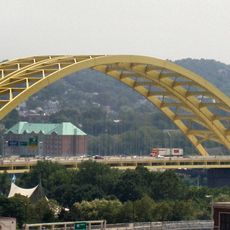
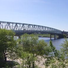
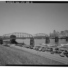
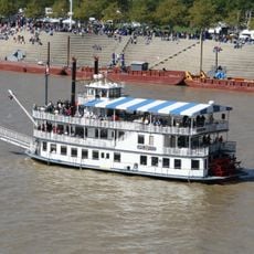
The Purple People Bridge is a pedestrian-only bridge connecting Newport and Cincinnati across the Ohio River using a Pratt truss metal structure. Its distinctive purple color makes it immediately recognizable, and it provides direct access to attractions on both sides of the river.

History

Originally built in 1872 as Cincinnati's first railroad bridge across the Ohio River, it was later strengthened in 1896 to handle heavier trains. Eventually the structure was repurposed for pedestrian use and painted its now-famous purple color.

Culture

The bridge serves as a social meeting place where residents and visitors gather for community events throughout the year. Walking across it has become part of how people connect the two neighborhoods in their daily lives.

Practical

The bridge is easy to access with level walkways suitable for most visitors. Since it is an open structure exposed to weather, plan your walk during fair conditions or bring appropriate gear for wind and rain.

Did you know?

The bridge was originally designed for trains and later repurposed as a pedestrian path, demonstrating how cities adapt old infrastructure for new uses. Its name comes directly from the purple paint applied during renovation, a color choice that became its most memorable feature.

Location
Location
Official opening
April 1, 1872
GPS coordinates
39.09802,-84.49775
Latest update
December 8, 2025 19:58

AroundUs brings together thousands of curated places, local tips, and hidden gems, enriched daily by 60,000 contributors worldwide. Discover all places nearby (Cincinnati).

Around this place
Riverfront Stadium
United States of America

Riverfront Stadium

927 m
Heritage Bank Center
United States of America

Heritage Bank Center

579 m
Miami and Erie Canal
United States of America

Miami and Erie Canal

321 m
Newport Aquarium
United States of America

Newport Aquarium

403 m
Great American Ball Park
United States of America

Great American Ball Park

773 m
Taft Museum of Art
United States of America

Taft Museum of Art

694 m
Daniel Carter Beard Bridge
United States of America

Daniel Carter Beard Bridge

402 m
Taylor–Southgate Bridge
United States of America

Taylor–Southgate Bridge

374 m
Fort Washington
United States of America

Fort Washington

850 m
World Peace Bell
United States of America

World Peace Bell

693 m
Majestic
United States of America

Majestic

497 m
Statue of Abraham Lincoln
United States of America

Statue of Abraham Lincoln

666 m
Christ Church Cathedral, Cincinnati
United States of America

Christ Church Cathedral, Cincinnati

897 m
Mansion Hill Historic District
United States of America

Mansion Hill Historic District

749 m
Reds Legends of Crosley Field
United States of America

Reds Legends of Crosley Field

773 m
Cincinnati Street Gas Lamps
United States of America

Cincinnati Street Gas Lamps

294 m
Cincinnati–Newport Bridge
United States of America

Cincinnati–Newport Bridge

360 m
General James Taylor Park
United States of America

General James Taylor Park

744 m
Bellevue
United States of America

Bellevue

488 m
Southgate Street School
United States of America

Southgate Street School

527 m
Cincinnati Reds Hall of Fame and Museum
United States of America

Cincinnati Reds Hall of Fame and Museum

928 m
Lytle Park
United States of America

Lytle Park

658 m
Lytle Park Historic District
United States of America

Lytle Park Historic District

736 m
AMC Newport on the Levee 20
United States of America

AMC Newport on the Levee 20

347 m
Yeatman's Cove
United States of America

Yeatman's Cove

327 m
Newport Courthouse Square Historic District
United States of America

Newport Courthouse Square Historic District

649 m
Southgate-Parker-Maddux House
United States of America

Southgate-Parker-Maddux House

535 m
Serpentine Wall
United States of America

Serpentine Wall

275 m
Show the full map
« Purple People Bridge - Pedestrian bridge between Newport and Cincinnati, United States » is provided by Around Us (aroundus.com). Images and texts are derived from Wikimedia project under a Creative Commons license. You are allowed to copy, distribute, and modify copies of this page, under the conditions set by the license, as long as this note is clearly visible.

Discover hidden gems everywhere you go!

From secret cafés to breathtaking viewpoints, skip the crowded tourist spots and find places that match your style. Our app makes it easy with voice search, smart filtering, route optimization, and insider tips from travelers worldwide. Download now for the complete mobile experience.

Around Us App Screenshot

A unique approach to discovering new places

Le Figaro

All the places worth exploring

France Info

A tailor-made excursion in just a few clicks

20 Minutes

Around Us
Travel Guide & Maps
Download

Send to your phone

QR Code
1

Open the camera app on your mobile.

2

Point at the QR code with your camera. A notification will appear.

3

Tap the notification to open the link.