Yorktown Formation, Geological formation in Virginia, United States.
The Yorktown Formation is a geological layer made of sand and shell deposits that spreads across Maryland, Virginia, North Carolina, and South Carolina. The layer contains abundant fossil remains of clams, snails, corals, and other sea creatures from ages past.
This layer formed about 5.3 to 2.6 million years ago during the Early and Middle Pliocene period, when this area lay beneath a sea. Scientists first recorded its details in 1906 and recognized its importance for understanding the region's ancient past.
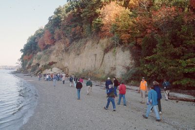
The layered sand and shell deposits visible here tell the story of an ancient ocean that once covered this region. Walking through the exposed bluffs, you can see tangible evidence of how the coastline looked long ago.
You can see the layer at several spots along the James River, especially at the Carters Grove and Moore House bluffs. The best way to understand what you are looking at is to take a slow walk through these areas and observe the different sand layers and shell remains.
The layer contains remains of Chesapectin jeffersonius, Virginia's official state fossil, showing how varied sea life was back then. This specific fossil became so important that it was chosen to represent the state's geological story.
The community of curious travelers
AroundUs brings together thousands of curated places, local tips, and hidden gems, enriched daily by 60,000 contributors worldwide.