Enable Location

We need your location to show you interesting places around you

Discover nearby places

Find interesting locations and hidden gems around you

Precise directions

Get accurate directions and distances to places

Your location is never shared with other users. It's only used when you tap the location button.

Wayne National Forest

Log in to your account

Start exploring — it's free

Trusted by 63,117 travelers worldwide

Continue with Google
Continue with Apple
or

We will send you a code to connect

By continuing, you accept our Terms and Conditions and our Privacy Policy

Check your inbox

We've sent a pincode in your inbox. Please enter the code below.

Wayne National Forest
Discussion Reviews 2 Photos
18.5k Popularity

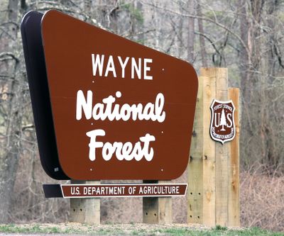
Wayne National Forest, National forest in Southeast Ohio, United States.

Wayne National Forest is a national forest in southeastern Ohio that spreads across thousands of acres with rolling hills, ravines, and streams running through the land. The forest is covered mostly in deciduous trees that create various natural habitats throughout the region.

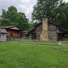
The forest was established by the federal government in 1992 and named after General Anthony Wayne from the American Revolutionary War. Much of the land was later acquired and brought under federal management from private ownership.

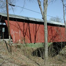
The North Country Trail intersects with the Buckeye Trail and American Discovery Trail through the forest, connecting multiple recreational paths for outdoor enthusiasts.

The forest is divided into three separate units, each with its own facilities and access points for visitors exploring the area. Camping is available during warmer months, though some locations may have restricted access during winter periods.

Much of the forest sits on land that was once mined for coal, with the federal government acquiring the surface while private owners retained mineral rights. This split ownership arrangement still shapes how the forest is managed and used today.

The community of curious travelers

AroundUs brings together thousands of curated places, local tips, and hidden gems, enriched daily by 60,000 contributors worldwide.

Start exploring
Location
Inception
1992
Part of
Southeast Ohio
GPS coordinates
39.05000,-82.05000
Latest update
December 7, 2025 19:22
Around this place
Silver Memorial Bridge
United States of America

Silver Memorial Bridge

25.4 km
Fort Randolph
United States of America

Fort Randolph

24.4 km
Tu-Endie-Wei State Park
United States of America

Tu-Endie-Wei State Park

24.7 km
Mothman Museum
United States of America

Mothman Museum

24.3 km
Ravenswood Bridge
United States of America

Ravenswood Bridge

28.3 km
Pomeroy–Mason Bridge
United States of America

Pomeroy–Mason Bridge

4.2 km
United States of America

Lake Snowden

25.1 km
Belleville Lock and Dam
United States of America

Belleville Lock and Dam

27.8 km
Ponn Humpback Covered Bridge
United States of America

Ponn Humpback Covered Bridge

28.2 km
United States of America

Marie J. Desonier State Nature Preserve

26.2 km
Racine Lock and Dam
United States of America

Racine Lock and Dam

19.2 km
Point Pleasant Rail Bridge
United States of America

Point Pleasant Rail Bridge

24 km
Meigs County Courthouse
United States of America

Meigs County Courthouse

2.8 km
Point Pleasant Historic District
United States of America

Point Pleasant Historic District

24.1 km
Lewis-Capehart-Roseberry House
United States of America

Lewis-Capehart-Roseberry House

20.6 km
Ravenswood "Old Town" Historic District
United States of America

Ravenswood "Old Town" Historic District

27.5 km
Gallia County Courthouse
United States of America

Gallia County Courthouse

29.9 km
Eakin Mill Covered Bridge
United States of America

Eakin Mill Covered Bridge

28.2 km
The Gold Houses
United States of America

The Gold Houses

3.6 km
John Downing, Jr., House
United States of America

John Downing, Jr., House

5.2 km
Blackwood Covered Bridge
United States of America

Blackwood Covered Bridge

17.6 km
Middleport Public Library
United States of America

Middleport Public Library

5.5 km
Shumaker-Lewis House
United States of America

Shumaker-Lewis House

3.8 km
Savage-Stewart House
United States of America

Savage-Stewart House

29.8 km
William H. Grant House
United States of America

William H. Grant House

5.6 km
Powell-Redmond House
United States of America

Powell-Redmond House

5.5 km
Lemley-Wood-Sayer House
United States of America

Lemley-Wood-Sayer House

27.5 km
West Virginia State Farm Museum
United States of America

West Virginia State Farm Museum

14.9 km
Show the full map
Reviews
Share your experience

No review yet

Discussions
Start a discussion...

No discussion yet

« Wayne National Forest - National forest in Southeast Ohio, United States » is provided by Around Us (aroundus.com). Images and texts are derived from Wikimedia project under a Creative Commons license. You are allowed to copy, distribute, and modify copies of this page, under the conditions set by the license, as long as this note is clearly visible.

Discover hidden gems everywhere you go!

From secret cafés to breathtaking viewpoints, skip the crowded tourist spots and find places that match your style. Our app makes it easy with voice search, smart filtering, route optimization, and insider tips from travelers worldwide. Download now for the complete mobile experience.

Around Us App Screenshot

A unique approach to discovering new places

Le Figaro

All the places worth exploring

France Info

A tailor-made excursion in just a few clicks

20 Minutes

Around Us
Travel Guide & Maps
Download

Send to your phone

QR Code
1

Open the camera app on your mobile.

2

Point at the QR code with your camera. A notification will appear.

3

Tap the notification to open the link.