Enable Location

We need your location to show you interesting places around you

Discover nearby places

Find interesting locations and hidden gems around you

Precise directions

Get accurate directions and distances to places

Your location is never shared with other users. It's only used when you tap the location button.

Ambrose Light

Log in to your account

Start exploring — it's free

Trusted by 65,738 travelers worldwide

Continue with Google
Continue with Apple
or

We will send you a code to connect

By continuing, you accept our Terms and Conditions and our Privacy Policy

Check your inbox

We've sent a pincode in your inbox. Please enter the code below.

Ambrose Light
Discussion Reviews 1 Photos
13.8k Popularity

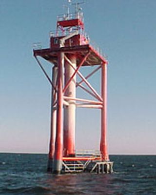
Ambrose Light, Maritime lighthouse at entrance of New York Harbor, United States

Ambrose Light was a lighthouse positioned at the entrance to New York Harbor to guide ships through the approach channels. The structure stood on a platform and emitted signals to help vessels navigate safely into port.

A lightship was first stationed at this location in 1823 to mark the harbor entrance for incoming vessels. The structure underwent modernization in the following decades to improve maritime navigation support.

The lighthouse served as a familiar landmark for ships approaching New York and became part of maritime tradition in the harbor. Generations of sailors recognized it as a gateway to the port.

The lighthouse was located far offshore in the Atlantic and could only be accessed by water. Today, visitors can only view the location from boat tours since the original structure no longer stands.

The structure suffered multiple collisions with ships over the years and was eventually replaced due to the frequency of such incidents. Luminous buoys proved to be a more reliable navigation aid than the original installation.

The community of curious travelers

AroundUs brings together thousands of curated places, local tips, and hidden gems, enriched daily by 60,000 contributors worldwide.

Start exploring
Location
GPS coordinates
40.45000,-73.80000
Latest update
December 7, 2025 20:24
Around this place
Jacob Riis Park
United States of America

Jacob Riis Park

14.5 km
Fort Tilden
United States of America

Fort Tilden

14.8 km
Marine Parkway-Gil Hodges Memorial Bridge
United States of America

Marine Parkway-Gil Hodges Memorial Bridge

15.5 km
Cross Bay Veterans Memorial Bridge
United States of America

Cross Bay Veterans Memorial Bridge

15.8 km
Navesink Twin Lights
United States of America

Navesink Twin Lights

16.8 km
Atlantic Beach Bridge
United States of America

Atlantic Beach Bridge

16.8 km
Gateway National Recreation Area
United States of America

Gateway National Recreation Area

16.7 km
Jacob Riis Park Beach 7
United States of America

Jacob Riis Park Beach 7

14.2 km
USS Salmon
United States of America

USS Salmon

10.5 km
Far Rockaway Beach Bungalow Historic District
United States of America

Far Rockaway Beach Bungalow Historic District

16.4 km
Kohlreiter Square
United States of America

Kohlreiter Square

15.7 km
Battery Gunnison
United States of America

Battery Gunnison

16.6 km
Fort Hancock and the Sandy Hook Proving Ground Historic District
United States of America

Fort Hancock and the Sandy Hook Proving Ground Historic District

16.6 km
Temple of Israel Synagogue
United States of America

Temple of Israel Synagogue

15.3 km
Fort Hancock, U.S. Life Saving Station
United States of America

Fort Hancock, U.S. Life Saving Station

15.9 km
Rockaway Courthouse
United States of America

Rockaway Courthouse

15.5 km
Battery Kingman
United States of America

Battery Kingman

16.3 km
Highlands–Sea Bright Bridge
United States of America

Highlands–Sea Bright Bridge

16.3 km
Beach C
United States of America

Beach C

15.7 km
Rockaway Beach
United States of America

Rockaway Beach

14.2 km
North Beach
United States of America

North Beach

17.2 km
Beach E
United States of America

Beach E

15.7 km
Navesink south lighthouse
United States of America

Navesink south lighthouse

16.9 km
Navesink north lighthouse
United States of America

Navesink north lighthouse

16.9 km
Fort Tilden Beach
United States of America

Fort Tilden Beach

14.4 km
FIshing Beach
United States of America

FIshing Beach

15.6 km
Sun and Surf Beach Club
United States of America

Sun and Surf Beach Club

15.8 km
Atlantic Beach
United States of America

Atlantic Beach

16.3 km
Show the full map
Reviews
Share your experience

No review yet

Discussions
Start a discussion...

No discussion yet

« Ambrose Light - Maritime lighthouse at entrance of New York Harbor, United States » is provided by Around Us (aroundus.com). Images and texts are derived from Wikimedia project under a Creative Commons license. You are allowed to copy, distribute, and modify copies of this page, under the conditions set by the license, as long as this note is clearly visible.

Discover hidden gems everywhere you go!

From secret cafés to breathtaking viewpoints, skip the crowded tourist spots and find places that match your style. Our app makes it easy with voice search, smart filtering, route optimization, and insider tips from travelers worldwide. Download now for the complete mobile experience.

Around Us App Screenshot

A unique approach to discovering new places

Le Figaro

All the places worth exploring

France Info

A tailor-made excursion in just a few clicks

20 Minutes

Around Us
Travel Guide & Maps
Download

Send to your phone

QR Code
1

Open the camera app on your mobile.

2

Point at the QR code with your camera. A notification will appear.

3

Tap the notification to open the link.