Arbitration Rock

Log in to your account

AroundUs is a community-driven map of interesting places, built by curious explorers like you. It grows with every review, story, and photo you share.
Connect to save your favorite spots, contribute locations, and create personalized routes.
Continue with Google
Continue with Apple
Continue with X
Continue with Facebook
Continue with email
By continuing, you accept our Terms and Conditions and our Privacy Policy
Create an account

Arbitration Rock

Add to collection
Map
Suggest a change
Share

Arbitration Rock, Historical boundary marker between Brooklyn and Queens, New York, United States.

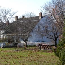
Arbitration Rock is a large glacial boulder sitting in the yard of the Van der Ende-Onderdonk House that once marked the dividing line between Brooklyn and Queens. The stone bears the marks of ancient ice age glaciers that scraped and shaped the landscape thousands of years ago.

Surveyor Peter Marschalk placed this boundary marker in 1769 to end a century-long dispute over where Brooklyn and Queens should be separated. The decision settled arguments that had divided the two communities for generations.

The rock marks where Dutch and English colonial communities once met and negotiated their separate territories. It reflects how these early settlements shaped the way the city eventually divided into distinct boroughs.

The site sits in a quiet residential neighborhood in Queens and is easy to reach on foot from nearby streets. Visiting during the house's open hours lets you see both the stone and learn more about the area's past through displays inside.

This stone was buried and forgotten for decades as the city developed, disappearing from view until locals rediscovered it in 2001. It was then moved to its current spot next to the old house where visitors can finally see it again.

Location: New York

GPS coordinates: 40.71070,-73.91960

Latest update: December 13, 2025 11:41

Photos
Around this place
Eyebeam Art and Technology Center
United States of America

Eyebeam Art and Technology Center

1.5 km
McKibbin Street Lofts
United States of America

McKibbin Street Lofts

1.6 km
Metropolitan Oval
United States of America

Metropolitan Oval

1.2 km
Wyckoff Heights, New York
United States of America

Wyckoff Heights, New York

859 m
Cooper Park
United States of America

Cooper Park

1.6 km
Grand Street Bridge
United States of America

Grand Street Bridge

698 m
William Ulmer Brewery
United States of America

William Ulmer Brewery

1.9 km
Vander Ende-Onderdonk House
United States of America

Vander Ende-Onderdonk House

57 m
United States of America

Grand Street Campus

1.6 km
St. Matthias Roman Catholic Church Complex
United States of America

St. Matthias Roman Catholic Church Complex

1.7 km
Central Ridgewood Historic District
United States of America

Central Ridgewood Historic District

1.9 km
South Bushwick Reformed Church
United States of America

South Bushwick Reformed Church

1.9 km
Bushwick Democratic Club House
United States of America

Bushwick Democratic Club House

1.8 km
Cypress Avenue West Historic District
United States of America

Cypress Avenue West Historic District

942 m
Cypress Avenue East Historic District
United States of America

Cypress Avenue East Historic District

1.4 km
Seneca Avenue East Historic District
United States of America

Seneca Avenue East Historic District

1.9 km
Stockholm-DeKalb-Hart Historic District
United States of America

Stockholm-DeKalb-Hart Historic District

480 m
Woodbine-Palmetto-Gates Historic District
United States of America

Woodbine-Palmetto-Gates Historic District

1.4 km
Grove-Linden-St. John's Historic District
United States of America

Grove-Linden-St. John's Historic District

1.1 km
Seneca-Onderdonk-Woodward Historic District
United States of America

Seneca-Onderdonk-Woodward Historic District

1.6 km
Madison-Putnam-60th Place Historic District
United States of America

Madison-Putnam-60th Place Historic District

1.6 km
Cornelia-Putnam Historic District
United States of America

Cornelia-Putnam Historic District

1.7 km
Fresh Pond-Traffic Historic District
United States of America

Fresh Pond-Traffic Historic District

1.9 km
Willoughby-Suydam Historic District
United States of America

Willoughby-Suydam Historic District

548 m
The Bone Museum
United States of America

The Bone Museum

1.6 km
Industrial Complex at 221 McKibbin Street
United States of America

Industrial Complex at 221 McKibbin Street

1.7 km
DeKalb Library
United States of America

DeKalb Library

1.9 km
Under The K Bridge Park
United States of America

Under The K Bridge Park

2 km
Show the full map
Reviews

Visited this place? Tap the stars to rate it and share your experience / photos with the community! Try now! You can cancel it anytime.

« Arbitration Rock - Historical boundary marker between Brooklyn and Queens, New York, United States » is provided by Around Us (aroundus.com). Images and texts are derived from Wikimedia project under a Creative Commons license. You are allowed to copy, distribute, and modify copies of this page, under the conditions set by the license, as long as this note is clearly visible.

Discover hidden gems everywhere you go!

From secret cafés to breathtaking viewpoints, skip the crowded tourist spots and find places that match your style. Our app makes it easy with voice search, smart filtering, route optimization, and insider tips from travelers worldwide. Download now for the complete mobile experience.

Around Us App Screenshot

A unique approach to discovering new places

Le Figaro

All the places worth exploring

France Info

A tailor-made excursion in just a few clicks

20 Minutes