Enable Location

We need your location to show you interesting places around you

Discover nearby places

Find interesting locations and hidden gems around you

Precise directions

Get accurate directions and distances to places

Your location is never shared with other users. It's only used when you tap the location button.

Log in to your account

Start exploring — it's free

Trusted by 62,479 travelers worldwide

Continue with Google
Continue with Apple
or

We will send you a code to connect

By continuing, you accept our Terms and Conditions and our Privacy Policy

Check your inbox

We've sent a pincode in your inbox. Please enter the code below.

Bringle Ferry Bridge

Bringle Ferry Bridge, bridge in United States of America

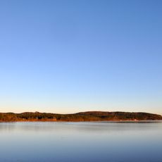
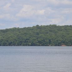
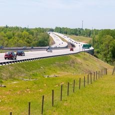
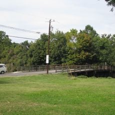
Bringle Ferry Bridge is a road bridge that crosses the Yadkin River in North Carolina, connecting Salisbury and Denton. The structure of metal and concrete allows vehicles to pass over the river while offering views of the slow-flowing water and surrounding landscape below.

The bridge was built many decades ago and has been a steady part of connecting communities across the Yadkin River. It has enabled generations of vehicles and travelers to cross the waterway and has supported the regional network.

The bridge is a familiar landmark in the daily routines of local residents, connecting two communities across the Yadkin River. For people who live nearby, it holds quiet importance as a symbol of connection between neighboring areas.

The bridge is the only vehicle crossing between the Interstate 85 bridge at Spencer and the North Carolina Highway 49 bridge near Richfield, making it essential for local traffic. Visitors should note that occasional maintenance work may cause temporary closures requiring alternative routes.

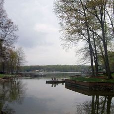
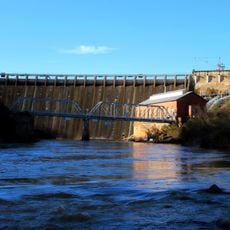
From the bridge, visitors can look north and see the High Rock Dam, which blocks the river to create Tuckertown Reservoir and High Rock Lake. This view of the dam structure and the expansive water behind it is a popular photography spot for travelers in the region.

The community of curious travelers

AroundUs brings together thousands of curated places, local tips, and hidden gems, enriched daily by 60,000 contributors worldwide.

Start exploring
Location
GPS coordinates
35.59670,-80.23170
Latest update
February 9, 2026 07:41
Around this place
High Rock Lake
United States of America

High Rock Lake

4 km
Badin Lake
United States of America

Badin Lake

23.4 km
North Carolina Transportation Museum
United States of America

North Carolina Transportation Museum

21 km
Salisbury National Cemetery
United States of America

Salisbury National Cemetery

23.1 km
Tuckertown Reservoir
United States of America

Tuckertown Reservoir

11.8 km
Hardaway Site
United States of America

Hardaway Site

23.3 km
Michael Braun House
United States of America

Michael Braun House

19.2 km
Narrows Dam and Power Plant Complex
United States of America

Narrows Dam and Power Plant Complex

23.5 km
Salisbury Historic District
United States of America

Salisbury Historic District

22.9 km
McNeely-Strachan House
United States of America

McNeely-Strachan House

23.3 km
Yadkin River Veterans Memorial Bridge
United States of America

Yadkin River Veterans Memorial Bridge

19.7 km
John Steele House
United States of America

John Steele House

22.3 km
Archibald Henderson Law Office
United States of America

Archibald Henderson Law Office

23.1 km
Bernhardt House
United States of America

Bernhardt House

22.7 km
Maxwell Chambers House
United States of America

Maxwell Chambers House

23.2 km
Mount Zion Baptist Church
United States of America

Mount Zion Baptist Church

22.9 km
Community Building
United States of America

Community Building

22.9 km
Walter McCanless House
United States of America

Walter McCanless House

23.5 km
Grimes Mill
United States of America

Grimes Mill

22.8 km
Kerr Mill
United States of America

Kerr Mill

19.3 km
Shaver Rental Houses District
United States of America

Shaver Rental Houses District

23.2 km
Shober Bridge
United States of America

Shober Bridge

23.3 km
Denton Farmpark
United States of America

Denton Farmpark

14.6 km
Kesler Manufacturing Co.-Cannon Mills Co. Plant No. 7 Historic District
United States of America

Kesler Manufacturing Co.-Cannon Mills Co. Plant No. 7 Historic District

22.7 km
Mount Ebal Methodist Protestant Church
United States of America

Mount Ebal Methodist Protestant Church

15.2 km
Salisbury Railroad Corridor Historic District
United States of America

Salisbury Railroad Corridor Historic District

22.5 km
North Long Street-Park Avenue Historic District
United States of America

North Long Street-Park Avenue Historic District

22.2 km
Ellis Street Graded School Historic District
United States of America

Ellis Street Graded School Historic District

23.2 km
Show the full map
« Bringle Ferry Bridge - bridge in United States of America » is provided by Around Us (aroundus.com). Images and texts are derived from Wikimedia project under a Creative Commons license. You are allowed to copy, distribute, and modify copies of this page, under the conditions set by the license, as long as this note is clearly visible.

Discover hidden gems everywhere you go!

From secret cafés to breathtaking viewpoints, skip the crowded tourist spots and find places that match your style. Our app makes it easy with voice search, smart filtering, route optimization, and insider tips from travelers worldwide. Download now for the complete mobile experience.

Around Us App Screenshot

A unique approach to discovering new places

Le Figaro

All the places worth exploring

France Info

A tailor-made excursion in just a few clicks

20 Minutes

Around Us
Travel Guide & Maps
Download

Send to your phone

QR Code
1

Open the camera app on your mobile.

2

Point at the QR code with your camera. A notification will appear.

3

Tap the notification to open the link.