Enable Location

We need your location to show you interesting places around you

Discover nearby places

Find interesting locations and hidden gems around you

Precise directions

Get accurate directions and distances to places

Your location is never shared with other users. It's only used when you tap the location button.

Caughnawaga Indian Village Site

Log in to your account

Start exploring — it's free

Trusted by 64,466 travelers worldwide

Continue with Google
Continue with Apple
or

We will send you a code to connect

By continuing, you accept our Terms and Conditions and our Privacy Policy

Check your inbox

We've sent a pincode in your inbox. Please enter the code below.

Discussion Reviews 1 Photos
4.6k Popularity

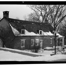
Caughnawaga Indian Village Site, Archaeological site near Fonda, New York, United States.

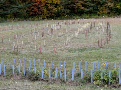
Caughnawaga Indian Village Site is an archaeological site near Fonda, New York, featuring excavated remains of a Mohawk village on the south bank of the Mohawk River. Wooden stakes mark the outlines of longhouses and defensive structures, giving a clear sense of how the village was laid out.

The village was founded in 1666 and served as home to a Mohawk community until it was abandoned following an attack in 1693. After leaving, part of the population moved north to Canada and gave their name to a new settlement there.

Visitors can still read the traces of daily Mohawk life through the objects and structures found during excavation. The presence of a Christian mission introduced new languages and practices that left a clear mark on the kinds of artifacts uncovered here.

The site is open-air and free to visit, and walking the full area gives the best sense of its layout. The ground is uneven in places, so sturdy footwear is a good idea, especially after rain.

This is the only fully excavated Mohawk village in the United States, first uncovered in 1950 by Reverend Thomas Grassmann. The thorough dig made it possible to map nearly the entire internal layout of the settlement, something rarely achieved at sites of this kind.

The community of curious travelers

AroundUs brings together thousands of curated places, local tips, and hidden gems, enriched daily by 60,000 contributors worldwide.

Start exploring
Location
GPS coordinates
42.95499,-74.39300
Latest update
March 3, 2026 08:14
Around this place
Schoharie Creek Bridge collapse
United States of America

Schoharie Creek Bridge collapse

9.7 km
National Shrine of the North American Martyrs
United States of America

National Shrine of the North American Martyrs

8.1 km
Johnson Hall State Historic Site
United States of America

Johnson Hall State Historic Site

6.9 km
Webster Wagner House
United States of America

Webster Wagner House

15.2 km
Schoharie Crossing State Historic Site
United States of America

Schoharie Crossing State Historic Site

8.9 km
Old Fort Johnson
United States of America

Old Fort Johnson

12.3 km
Guy Park
United States of America

Guy Park

14.9 km
Arkell Museum
United States of America

Arkell Museum

15.5 km
Knox Mansion
United States of America

Knox Mansion

5.3 km
Amsterdam City Hall
United States of America

Amsterdam City Hall

10.8 km
Reformed Dutch Church of Stone Arabia
United States of America

Reformed Dutch Church of Stone Arabia

13.4 km
West Hill School
United States of America

West Hill School

15.7 km
Van Alstyne House
United States of America

Van Alstyne House

15.7 km
Gloversville Free Library
United States of America

Gloversville Free Library

11.4 km
Fulton County Courthouse
United States of America

Fulton County Courthouse

5.9 km
Log Cabin Church
United States of America

Log Cabin Church

12.8 km
Downtown Gloversville Historic District
United States of America

Downtown Gloversville Historic District

11.4 km
Guy Park Avenue School
United States of America

Guy Park Avenue School

15 km
First United Methodist Church
United States of America

First United Methodist Church

11.4 km
Gloversville Armory
United States of America

Gloversville Armory

11.4 km
Kingsboro Historic District
United States of America

Kingsboro Historic District

13.3 km
First Baptist Church
United States of America

First Baptist Church

12.5 km
Canajoharie Falls
United States of America

Canajoharie Falls

15.7 km
Gustav Levor House
United States of America

Gustav Levor House

11.7 km
Canajoharie Historic District
United States of America

Canajoharie Historic District

15.6 km
Bragdon-Lipe House
United States of America

Bragdon-Lipe House

15.8 km
Glen Historic District
United States of America

Glen Historic District

7.9 km
Benjamin Chamberlain House
United States of America

Benjamin Chamberlain House

5.7 km
Show the full map
Reviews
Share your experience

No review yet

Discussions
Start a discussion...

No discussion yet

« Caughnawaga Indian Village Site - Archaeological site near Fonda, New York, United States » is provided by Around Us (aroundus.com). Images and texts are derived from Wikimedia project under a Creative Commons license. You are allowed to copy, distribute, and modify copies of this page, under the conditions set by the license, as long as this note is clearly visible.

Discover hidden gems everywhere you go!

From secret cafés to breathtaking viewpoints, skip the crowded tourist spots and find places that match your style. Our app makes it easy with voice search, smart filtering, route optimization, and insider tips from travelers worldwide. Download now for the complete mobile experience.

Around Us App Screenshot

A unique approach to discovering new places

Le Figaro

All the places worth exploring

France Info

A tailor-made excursion in just a few clicks

20 Minutes

Around Us
Travel Guide & Maps
Download

Send to your phone

QR Code
1

Open the camera app on your mobile.

2

Point at the QR code with your camera. A notification will appear.

3

Tap the notification to open the link.