Enable Location

We need your location to show you interesting places around you

Discover nearby places

Find interesting locations and hidden gems around you

Precise directions

Get accurate directions and distances to places

Your location is never shared with other users. It's only used when you tap the location button.

Schoharie Creek Bridge collapse

Log in to your account

Start exploring — it's free

Trusted by 63,070 travelers worldwide

Continue with Google
Continue with Apple
or

We will send you a code to connect

By continuing, you accept our Terms and Conditions and our Privacy Policy

Check your inbox

We've sent a pincode in your inbox. Please enter the code below.

Schoharie Creek Bridge collapse
Discussion Reviews 1 Photos
14.5k Popularity

Schoharie Creek Bridge collapse, Former road bridge near Fort Hunter, New York, USA.

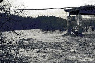
The Schoharie Creek Bridge was a road structure spanning the creek along Interstate 90, with support piers embedded in the streambed. Its foundation design lacked adequate safeguards against water erosion around the base.

On April 5, 1987, heavy rainfall and snowmelt caused the structure to collapse, killing ten people in the disaster. The failure resulted from erosion around the piers and insufficient maintenance over time.

The collapse sparked conversations about infrastructure responsibility across the country and shaped how engineers approach maintenance planning today.

The site has no public access today, as the creek area remains a hazard zone with debris underwater. Travelers passing through on Interstate 90 can observe a historical marker indicating where the incident occurred.

The collapse happened in stages rather than all at once: three separate bridge sections fell within ninety minutes as the initial failure weakened the remaining structure. This cascading pattern changed how engineers design protections against progressive pier failure.

The community of curious travelers

AroundUs brings together thousands of curated places, local tips, and hidden gems, enriched daily by 60,000 contributors worldwide.

Start exploring
Location
GPS coordinates
42.93083,-74.27806
Latest update
December 7, 2025 20:21
Around this place
National Shrine of the North American Martyrs
United States of America

National Shrine of the North American Martyrs

2 km
Johnson Hall State Historic Site
United States of America

Johnson Hall State Historic Site

12.8 km
Caughnawaga Indian Village Site
United States of America

Caughnawaga Indian Village Site

9.7 km
Schoharie Crossing State Historic Site
United States of America

Schoharie Crossing State Historic Site

1.2 km
Old Fort Johnson
United States of America

Old Fort Johnson

4.2 km
Tryon County Jail
United States of America

Tryon County Jail

11 km
Guy Park
United States of America

Guy Park

5.8 km
Knox Mansion
United States of America

Knox Mansion

11 km
Greene Mansion
United States of America

Greene Mansion

7.2 km
Amsterdam City Hall
United States of America

Amsterdam City Hall

1.6 km
United States of America

George Landis Arboretum

16.3 km
Saint Stanislaus Roman Catholic Church Complex
United States of America

Saint Stanislaus Roman Catholic Church Complex

7.9 km
Mohawk Valley Gateway Overlook pedestrian bridge
United States of America

Mohawk Valley Gateway Overlook pedestrian bridge

6.8 km
Gloversville Free Library
United States of America

Gloversville Free Library

14.3 km
Chalmers Knitting Mills
United States of America

Chalmers Knitting Mills

6.7 km
Fulton County Courthouse
United States of America

Fulton County Courthouse

11.6 km
Log Cabin Church
United States of America

Log Cabin Church

12.5 km
Downtown Gloversville Historic District
United States of America

Downtown Gloversville Historic District

14.4 km
Guy Park Avenue School
United States of America

Guy Park Avenue School

6 km
First United Methodist Church
United States of America

First United Methodist Church

14.6 km
Temple of Israel
United States of America

Temple of Israel

6.9 km
Gray-Jewett House
United States of America

Gray-Jewett House

6.4 km
Gloversville Armory
United States of America

Gloversville Armory

14.2 km
Kingsboro Historic District
United States of America

Kingsboro Historic District

15.9 km
First Baptist Church
United States of America

First Baptist Church

10.7 km
Gustav Levor House
United States of America

Gustav Levor House

14.6 km
Vrooman Avenue School
United States of America

Vrooman Avenue School

8.4 km
Glen Historic District
United States of America

Glen Historic District

6.6 km
Show the full map
Reviews
Share your experience

No review yet

Discussions
Start a discussion...

No discussion yet

« Schoharie Creek Bridge collapse - Former road bridge near Fort Hunter, New York, USA » is provided by Around Us (aroundus.com). Images and texts are derived from Wikimedia project under a Creative Commons license. You are allowed to copy, distribute, and modify copies of this page, under the conditions set by the license, as long as this note is clearly visible.

Discover hidden gems everywhere you go!

From secret cafés to breathtaking viewpoints, skip the crowded tourist spots and find places that match your style. Our app makes it easy with voice search, smart filtering, route optimization, and insider tips from travelers worldwide. Download now for the complete mobile experience.

Around Us App Screenshot

A unique approach to discovering new places

Le Figaro

All the places worth exploring

France Info

A tailor-made excursion in just a few clicks

20 Minutes

Around Us
Travel Guide & Maps
Download

Send to your phone

QR Code
1

Open the camera app on your mobile.

2

Point at the QR code with your camera. A notification will appear.

3

Tap the notification to open the link.