Enable Location

We need your location to show you interesting places around you

Discover nearby places

Find interesting locations and hidden gems around you

Precise directions

Get accurate directions and distances to places

Your location is never shared with other users. It's only used when you tap the location button.

Mohawk Valley Gateway Overlook pedestrian bridge

Log in to your account

Start exploring — it's free

Trusted by 61,906 travelers worldwide

Continue with Google
Continue with Apple
or

We will send you a code to connect

By continuing, you accept our Terms and Conditions and our Privacy Policy

Check your inbox

We've sent a pincode in your inbox. Please enter the code below.

Mohawk Valley Gateway Overlook pedestrian bridge

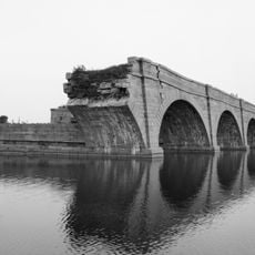
Mohawk Valley Gateway Overlook pedestrian bridge, Pedestrian bridge in Amsterdam, New York.

The Mohawk Valley Gateway Overlook is a pedestrian bridge spanning 511 feet across the Mohawk River, connecting residential areas south of downtown with Amsterdam's central districts and Riverlink Park. The structure features covered sections, railings, and open access from both sides.

Construction of the bridge was completed in 2016 following a decade of planning and development work. The project emerged from efforts to revitalize the community and restore connections between neighborhoods separated by the river.

Twelve stopping points along the walkway share stories about Native Americans, early settlers, immigrants, and how canals and railroads shaped the valley over time. Each location invites visitors to learn about the diverse people who built this region.

The bridge is located at Bridge Street in central Amsterdam and remains open 24 hours daily for public use. Signs along the way direct visitors toward the Erie Canalway Trail and other nearby riverside destinations.

At the bridge's highest point sits a 12-foot glass mosaic called the Wheel of Life, created using Venetian glasswork methods. This piece echoes a similar design found at the Waldorf Astoria Hotel in Manhattan.

The community of curious travelers

AroundUs brings together thousands of curated places, local tips, and hidden gems, enriched daily by 60,000 contributors worldwide.

Start exploring
GPS coordinates
42.93560,-74.19470
Latest update
December 14, 2025 15:01
Around this place
Schoharie Creek Bridge collapse
United States of America

Schoharie Creek Bridge collapse

6.8 km
National Shrine of the North American Martyrs
United States of America

National Shrine of the North American Martyrs

8.8 km
Caughnawaga Indian Village Site
United States of America

Caughnawaga Indian Village Site

16.3 km
Schoharie Crossing State Historic Site
United States of America

Schoharie Crossing State Historic Site

7.5 km
Mabee House
United States of America

Mabee House

15.4 km
Old Fort Johnson
United States of America

Old Fort Johnson

4.5 km
Guy Park
United States of America

Guy Park

1.8 km
Knox Mansion
United States of America

Knox Mansion

16.3 km
Greene Mansion
United States of America

Greene Mansion

582 m
Amsterdam City Hall
United States of America

Amsterdam City Hall

5.5 km
Saint Stanislaus Roman Catholic Church Complex
United States of America

Saint Stanislaus Roman Catholic Church Complex

1.4 km
Gloversville Free Library
United States of America

Gloversville Free Library

17.6 km
Chalmers Knitting Mills
United States of America

Chalmers Knitting Mills

142 m
Fulton County Courthouse
United States of America

Fulton County Courthouse

16.7 km
Log Cabin Church
United States of America

Log Cabin Church

14.4 km
Downtown Gloversville Historic District
United States of America

Downtown Gloversville Historic District

17.7 km
Guy Park Avenue School
United States of America

Guy Park Avenue School

1.9 km
West Charlton United Presbyterian Church
United States of America

West Charlton United Presbyterian Church

14 km
Gray-Jewett House
United States of America

Gray-Jewett House

485 m
Temple of Israel
United States of America

Temple of Israel

428 m
Gloversville Armory
United States of America

Gloversville Armory

17.4 km
First Baptist Church
United States of America

First Baptist Church

15.6 km
Gustav Levor House
United States of America

Gustav Levor House

17.7 km
Vrooman Avenue School
United States of America

Vrooman Avenue School

1.6 km
Mariaville Historic District
United States of America

Mariaville Historic District

12.9 km
Glen Historic District
United States of America

Glen Historic District

12.9 km
Benjamin Chamberlain House
United States of America

Benjamin Chamberlain House

16.4 km
Mabee Farm Historic Site
United States of America

Mabee Farm Historic Site

15.3 km
Show the full map
« Mohawk Valley Gateway Overlook pedestrian bridge - Pedestrian bridge in Amsterdam, New York » is provided by Around Us (aroundus.com). Images and texts are derived from Wikimedia project under a Creative Commons license. You are allowed to copy, distribute, and modify copies of this page, under the conditions set by the license, as long as this note is clearly visible.

Discover hidden gems everywhere you go!

From secret cafés to breathtaking viewpoints, skip the crowded tourist spots and find places that match your style. Our app makes it easy with voice search, smart filtering, route optimization, and insider tips from travelers worldwide. Download now for the complete mobile experience.

Around Us App Screenshot

A unique approach to discovering new places

Le Figaro

All the places worth exploring

France Info

A tailor-made excursion in just a few clicks

20 Minutes

Around Us
Travel Guide & Maps
Download

Send to your phone

QR Code
1

Open the camera app on your mobile.

2

Point at the QR code with your camera. A notification will appear.

3

Tap the notification to open the link.