Enable Location

We need your location to show you interesting places around you

Discover nearby places

Find interesting locations and hidden gems around you

Precise directions

Get accurate directions and distances to places

Your location is never shared with other users. It's only used when you tap the location button.

Fulton County Courthouse

Log in to your account

Start exploring — it's free

Trusted by 62,441 travelers worldwide

Continue with Google
Continue with Apple
or

We will send you a code to connect

By continuing, you accept our Terms and Conditions and our Privacy Policy

Check your inbox

We've sent a pincode in your inbox. Please enter the code below.

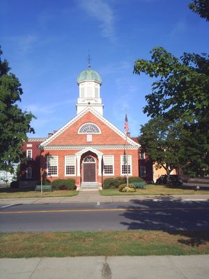
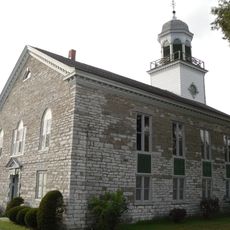
Fulton County Courthouse, courthouse in New York, United States

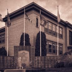
The Fulton County Courthouse is a courthouse in Johnstown that has been operating since 1772. The building stands on West Main Street and features an original bell in its tower along with several historic rooms used for court proceedings and important local gatherings over more than two centuries.

The courthouse was built in 1772, just before the American Revolution, and is the oldest continuously operating courthouse in New York. The region experienced battles during the war, including the Battle of Johnstown just 17 days after a court session, and later became the seat of justice under the name Montgomery County before finally becoming Fulton County.

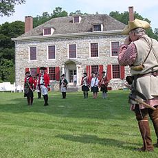
The courthouse played a central role in Johnstown's founding, with Irish settler Sir William Johnson directing its development and negotiating directly with the Mohawk people. The building and surrounding streets still reflect these early connections between European settlers and the indigenous population.

The courthouse is located downtown on West Main Street in Johnstown and is easily accessible on foot. The building remains active today and can be viewed from outside, with visitors able to spot markers that point to its historical importance and connections to significant people.

A bell tower with an original bell that was rung to mark important historical moments like Cornwallis's surrender remains a landmark of the courthouse. This bell connects the modern court daily to sounds from colonial times.

The community of curious travelers

AroundUs brings together thousands of curated places, local tips, and hidden gems, enriched daily by 60,000 contributors worldwide.

Start exploring
Location
GPS coordinates
43.00667,-74.37556
Latest update
February 9, 2026 11:07
Around this place
Schoharie Creek Bridge collapse
United States of America

Schoharie Creek Bridge collapse

11.6 km
National Shrine of the North American Martyrs
United States of America

National Shrine of the North American Martyrs

10.8 km
Johnson Hall State Historic Site
United States of America

Johnson Hall State Historic Site

1.2 km
Caughnawaga Indian Village Site
United States of America

Caughnawaga Indian Village Site

5.9 km
Schoharie Crossing State Historic Site
United States of America

Schoharie Crossing State Historic Site

10.4 km
Old Fort Johnson
United States of America

Old Fort Johnson

12.2 km
Guy Park
United States of America

Guy Park

15 km
Knox Mansion
United States of America

Knox Mansion

686 m
Greene Mansion
United States of America

Greene Mansion

16.8 km
Amsterdam City Hall
United States of America

Amsterdam City Hall

11.9 km
Reformed Dutch Church of Stone Arabia
United States of America

Reformed Dutch Church of Stone Arabia

16.4 km
Saint Stanislaus Roman Catholic Church Complex
United States of America

Saint Stanislaus Roman Catholic Church Complex

17.2 km
Mohawk Valley Gateway Overlook pedestrian bridge
United States of America

Mohawk Valley Gateway Overlook pedestrian bridge

16.7 km
Gloversville Free Library
United States of America

Gloversville Free Library

5.5 km
Chalmers Knitting Mills
United States of America

Chalmers Knitting Mills

16.6 km
Log Cabin Church
United States of America

Log Cabin Church

7.9 km
Downtown Gloversville Historic District
United States of America

Downtown Gloversville Historic District

5.5 km
Guy Park Avenue School
United States of America

Guy Park Avenue School

15 km
First United Methodist Church
United States of America

First United Methodist Church

5.6 km
Temple of Israel
United States of America

Temple of Israel

16.5 km
Gray-Jewett House
United States of America

Gray-Jewett House

16.5 km
Gloversville Armory
United States of America

Gloversville Armory

5.6 km
Kingsboro Historic District
United States of America

Kingsboro Historic District

7.4 km
First Baptist Church
United States of America

First Baptist Church

17.8 km
Gustav Levor House
United States of America

Gustav Levor House

5.9 km
Vrooman Avenue School
United States of America

Vrooman Avenue School

18.2 km
Glen Historic District
United States of America

Glen Historic District

12.8 km
Benjamin Chamberlain House
United States of America

Benjamin Chamberlain House

359 m
Show the full map
« Fulton County Courthouse - courthouse in New York, United States » is provided by Around Us (aroundus.com). Images and texts are derived from Wikimedia project under a Creative Commons license. You are allowed to copy, distribute, and modify copies of this page, under the conditions set by the license, as long as this note is clearly visible.

Discover hidden gems everywhere you go!

From secret cafés to breathtaking viewpoints, skip the crowded tourist spots and find places that match your style. Our app makes it easy with voice search, smart filtering, route optimization, and insider tips from travelers worldwide. Download now for the complete mobile experience.

Around Us App Screenshot

A unique approach to discovering new places

Le Figaro

All the places worth exploring

France Info

A tailor-made excursion in just a few clicks

20 Minutes

Around Us
Travel Guide & Maps
Download

Send to your phone

QR Code
1

Open the camera app on your mobile.

2

Point at the QR code with your camera. A notification will appear.

3

Tap the notification to open the link.