Enable Location

We need your location to show you interesting places around you

Discover nearby places

Find interesting locations and hidden gems around you

Precise directions

Get accurate directions and distances to places

Your location is never shared with other users. It's only used when you tap the location button.

Clarion County Courthouse and Jail

Log in to your account

Start exploring — it's free

Trusted by 62,495 travelers worldwide

Continue with Google
Continue with Apple
or

We will send you a code to connect

By continuing, you accept our Terms and Conditions and our Privacy Policy

Check your inbox

We've sent a pincode in your inbox. Please enter the code below.

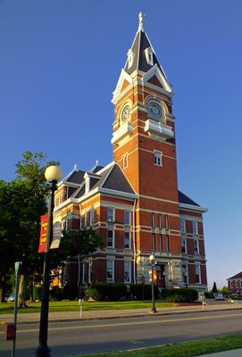
Clarion County Courthouse and Jail, Gerichtsgebäude in den Vereinigten Staaten

The Clarion County Courthouse is a courthouse in Pennsylvania listed on the National Register of Historic Places, featuring a clock tower over 200 feet (60 meters) tall. Built in brick with Queen Anne style design, it contains offices, courtrooms, and meeting spaces with decorative architectural details.

The original courthouse was built in 1843 but burned in 1859, followed by a second structure in 1863 that also burned in 1882. The current courthouse opened in 1883, representing the community's commitment to rebuilding after repeated fires.

The building carries the county's name and stands at the center of Clarion's civic identity. It reflects how the community has valued its institutions and judicial traditions since the 1800s.

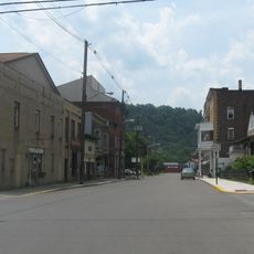
The building is easily found in downtown Clarion and remains visible from many parts of town. Visitors can explore the exterior and grounds on quiet streets while observing historical details and taking photos from public areas.

The Lady of Justice statue atop the tower bore around 25 bullet holes before being restored in 1981 and weighing more than double its original weight afterward. These marks tell the story of decades of exposure to weather and human impact.

The community of curious travelers

AroundUs brings together thousands of curated places, local tips, and hidden gems, enriched daily by 60,000 contributors worldwide.

Start exploring
Location
GPS coordinates
41.21530,-79.38580
Latest update
February 9, 2026 07:44
Around this place
Cook Forest State Park
United States of America

Cook Forest State Park

22.1 km
Foxburg Country Club
United States of America

Foxburg Country Club

25.6 km
Emlenton Bridge
United States of America

Emlenton Bridge

26.5 km
Clear Creek State Park
United States of America

Clear Creek State Park

27.8 km
Clear Creek State Forest
United States of America

Clear Creek State Forest

30 km
Parker Bridge
United States of America

Parker Bridge

27.7 km
Brookville Historic District
United States of America

Brookville Historic District

26.1 km
Rockland Furnace
United States of America

Rockland Furnace

30.5 km
Brookville Presbyterian Church and Manse
United States of America

Brookville Presbyterian Church and Manse

26 km
Foxburg Bridge
United States of America

Foxburg Bridge

26.1 km
Sutton-Ditz House
United States of America

Sutton-Ditz House

135 m
Bradys Bend Iron Company Furnaces
United States of America

Bradys Bend Iron Company Furnaces

31.4 km
Emlenton Historic District
United States of America

Emlenton Historic District

27.6 km
Emlenton Low Level Bridge
United States of America

Emlenton Low Level Bridge

27.4 km
Phillip Taylor House
United States of America

Phillip Taylor House

26.6 km
Buchanan Furnace
United States of America

Buchanan Furnace

17.2 km
Joseph E. Hall House
United States of America

Joseph E. Hall House

25.9 km
Anthony Wayne Cook Mansion
United States of America

Anthony Wayne Cook Mansion

19.8 km
Sergeant Carl F. Curran II Bridge
United States of America

Sergeant Carl F. Curran II Bridge

31.6 km
Gray-Taylor House
United States of America

Gray-Taylor House

26 km
Colwell Cut Viaduct
United States of America

Colwell Cut Viaduct

31.1 km
Foxburg Bridge
United States of America

Foxburg Bridge

26.1 km
Cook Forest State Park River Cabin District
United States of America

Cook Forest State Park River Cabin District

20.4 km
Cook Forest State Park Indian Cabin District
United States of America

Cook Forest State Park Indian Cabin District

19.9 km
Clear Creek State Park Day Use District
United States of America

Clear Creek State Park Day Use District

28.3 km
Clear Creek State Park Family Cabin District
United States of America

Clear Creek State Park Family Cabin District

27.1 km
East Brady Bridge
United States of America

East Brady Bridge

31.5 km
Cook Forest Tower
United States of America

Cook Forest Tower

18.8 km
Show the full map
« Clarion County Courthouse and Jail - Gerichtsgebäude in den Vereinigten Staaten » is provided by Around Us (aroundus.com). Images and texts are derived from Wikimedia project under a Creative Commons license. You are allowed to copy, distribute, and modify copies of this page, under the conditions set by the license, as long as this note is clearly visible.

Discover hidden gems everywhere you go!

From secret cafés to breathtaking viewpoints, skip the crowded tourist spots and find places that match your style. Our app makes it easy with voice search, smart filtering, route optimization, and insider tips from travelers worldwide. Download now for the complete mobile experience.

Around Us App Screenshot

A unique approach to discovering new places

Le Figaro

All the places worth exploring

France Info

A tailor-made excursion in just a few clicks

20 Minutes

Around Us
Travel Guide & Maps
Download

Send to your phone

QR Code
1

Open the camera app on your mobile.

2

Point at the QR code with your camera. A notification will appear.

3

Tap the notification to open the link.