Enable Location

We need your location to show you interesting places around you

Discover nearby places

Find interesting locations and hidden gems around you

Precise directions

Get accurate directions and distances to places

Your location is never shared with other users. It's only used when you tap the location button.

Foxburg Bridge

Log in to your account

Start exploring — it's free

Trusted by 60,637 travelers worldwide

Continue with Google
Continue with Apple
or

We will send you a code to connect

By continuing, you accept our Terms and Conditions and our Privacy Policy

Check your inbox

We've sent a pincode in your inbox. Please enter the code below.

Foxburg Bridge

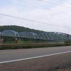
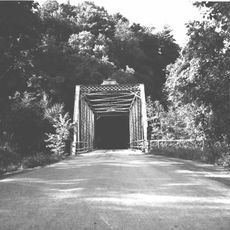
Foxburg Bridge, Railway and truss bridge in Foxburg, Pennsylvania, United States

Description

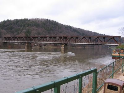
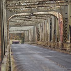
Foxburg Bridge was a railway and truss bridge spanning the Allegheny River in Foxburg, Pennsylvania, with a steel structure containing three sections supported by two piers. The double-deck design separated rail traffic on the upper level from vehicle traffic on the lower level.

History

The bridge was built in 1921 by the Bethlehem Steel Bridge Corporation, replacing an earlier wooden truss structure that had crossed the river. It served as a critical crossing for decades before its removal in 2008.

Culture

The bridge represented a major connection point between Armstrong County and Clarion County, supporting the regional transportation network for both trains and vehicles.

Practical

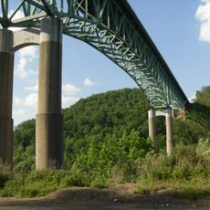
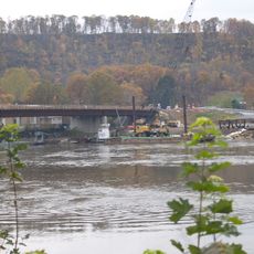
The bridge no longer stands, having been demolished in 2008, so visitors can only view the site where it once crossed the river. Historical photographs and documentation provide context for understanding what once stood at this location.

Did you know?

The demolition in 2008 was captured by the Discovery Channel program The Detonators, which documented the controlled explosion using strategically placed charges. This television documentation made the bridge's final moment a notable event in engineering history.

Location
Official opening
October 16, 1921
GPS coordinates
41.14000,-79.68100
Latest update
December 14, 2025 16:40

AroundUs brings together thousands of curated places, local tips, and hidden gems, enriched daily by 60,000 contributors worldwide. Discover all places nearby (Pennsylvania).

Around this place
Foxburg Country Club
United States of America

Foxburg Country Club

1.1 km
Wendell August Forge
United States of America

Wendell August Forge

32.2 km
Emlenton Bridge
United States of America

Emlenton Bridge

4.1 km
Fort Machault
United States of America

Fort Machault

29.8 km
Indian God Rock
United States of America

Indian God Rock

24.3 km
United States of America

Fort Venango

30.2 km
Jennings Environmental Education Center
United States of America

Jennings Environmental Education Center

30.6 km
Allegheny River Lock and Dam No. 9
United States of America

Allegheny River Lock and Dam No. 9

23.5 km
Parker Bridge
United States of America

Parker Bridge

4.2 km
Rockland Furnace
United States of America

Rockland Furnace

11.9 km
Samuel F. Dale House
United States of America

Samuel F. Dale House

31.5 km
Allegheny River Lock and Dam No. 8
United States of America

Allegheny River Lock and Dam No. 8

32.2 km
Sutton-Ditz House
United States of America

Sutton-Ditz House

26 km
Clarion County Courthouse and Jail
United States of America

Clarion County Courthouse and Jail

26.1 km
Bradys Bend Iron Company Furnaces
United States of America

Bradys Bend Iron Company Furnaces

16.4 km
Emlenton Historic District
United States of America

Emlenton Historic District

5.1 km
Emlenton Low Level Bridge
United States of America

Emlenton Low Level Bridge

4.6 km
St. Stephen's Church
United States of America

St. Stephen's Church

16.7 km
Buchanan Furnace
United States of America

Buchanan Furnace

10.3 km
Franklin Historic District
United States of America

Franklin Historic District

30.9 km
Sergeant Carl F. Curran II Bridge
United States of America

Sergeant Carl F. Curran II Bridge

17.6 km
Foxburg Bridge
United States of America

Foxburg Bridge

0 m
Bridge in Clinton Township
United States of America

Bridge in Clinton Township

18.2 km
Witherup Bridge
United States of America

Witherup Bridge

18.5 km
Oil City Pennsylvania Railroad Bridge
United States of America

Oil City Pennsylvania Railroad Bridge

31.5 km
Barrow Civic Theater
United States of America

Barrow Civic Theater

31.2 km
Oil City South Side Historic District
United States of America

Oil City South Side Historic District

31.5 km
East Brady Bridge
United States of America

East Brady Bridge

17.6 km
Show the full map
« Foxburg Bridge - Railway and truss bridge in Foxburg, Pennsylvania, United States » is provided by Around Us (aroundus.com). Images and texts are derived from Wikimedia project under a Creative Commons license. You are allowed to copy, distribute, and modify copies of this page, under the conditions set by the license, as long as this note is clearly visible.

Discover hidden gems everywhere you go!

From secret cafés to breathtaking viewpoints, skip the crowded tourist spots and find places that match your style. Our app makes it easy with voice search, smart filtering, route optimization, and insider tips from travelers worldwide. Download now for the complete mobile experience.

Around Us App Screenshot

A unique approach to discovering new places

Le Figaro

All the places worth exploring

France Info

A tailor-made excursion in just a few clicks

20 Minutes

Around Us
Travel Guide & Maps
Download

Send to your phone

QR Code
1

Open the camera app on your mobile.

2

Point at the QR code with your camera. A notification will appear.

3

Tap the notification to open the link.