Chest opened
+${chestReward.xp} XP
Explorer
NOUVEAU ×${chestReward.collectible.quantity}
tapez pour fermer
Chest locked

Open chests in the app

Around Us is built for your phone — chests unlock when you walk, explore and capture nearby places.

Enable Location

We need your location to show you interesting places around you

Discover nearby places

Find interesting locations and hidden gems around you

Precise directions

Get accurate directions and distances to places

Your location is never shared with other users. It's only used when you tap the location button.

Log in to your account

Start exploring — it's free

Trusted by 72,881 travelers worldwide

Continue with Google
Continue with Apple
or

We will send you a code to connect

By continuing, you accept our Terms and Conditions and our Privacy Policy

Check your inbox

We've sent a pincode in your inbox. Please enter the code below.

Clearwater Lake
Discussion Reviews Photo
5.9k Popularity

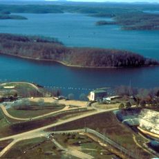
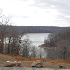
Clearwater Lake, on the border of Renolds and Wayne Counties in Missouri formed when Clearwater Dam was built

Clearwater Lake is a large reservoir in Missouri on the Black River near the town of Piedmont. The water is fed by springs that keep it clear and fresh, and the earthen and concrete dam was completed in 1948, rising over 100 feet tall.

The lake was built to control and prevent flooding in the region. Construction began in the 1940s but was paused during World War II before completion in 1948.

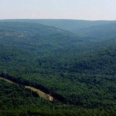
The lake takes its name from the clarity of its water, a quality noticed long before the dam was built. Today it remains part of the local landscape and reflects how people and nature coexist in the region.

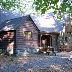
The lake is fairly easy to reach, with signs along nearby roads and parking areas near the main recreation spots. It is wise to arrive early, especially on weekends and holidays, to secure a good location.

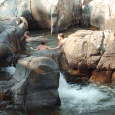
The water is fed by underground springs that keep it so clear that visitors notice the transparency when walking beside the shore or swimming. This clarity is what gave the lake its name and sets it apart from other reservoirs in the area.

The community of curious travelers

AroundUs brings together thousands of curated places, local tips, and hidden gems, enriched daily by 60,000 contributors worldwide.

Start exploring
Location
GPS coordinates
37.14307,-90.77656
Latest update
February 7, 2026 11:01
Around this place
Taum Sauk Mountain
United States of America

Taum Sauk Mountain

47.8 km
Johnson's Shut-Ins State Park
United States of America

Johnson's Shut-Ins State Park

44.8 km
Sam A. Baker State Park
United States of America

Sam A. Baker State Park

25.4 km
Lake Wappapello
United States of America

Lake Wappapello

47.8 km
Taum Sauk Mountain State Park
United States of America

Taum Sauk Mountain State Park

47.8 km
Arcadia College
United States of America

Arcadia College

50.7 km
Rodgers Theatre
United States of America

Rodgers Theatre

54.8 km
Jay Nixon State Park
United States of America

Jay Nixon State Park

49.9 km
Current River Cavern
United States of America

Current River Cavern

29.4 km
Williams-Gierth House
United States of America

Williams-Gierth House

54.4 km
North Main Street Historic District
United States of America

North Main Street Historic District

54.5 km
Mark Twain School
United States of America

Mark Twain School

53.6 km
St. Paul's Episcopal Church
United States of America

St. Paul's Episcopal Church

52.5 km
Thomas Moore House
United States of America

Thomas Moore House

54.6 km
Walter Klepzig Mill and Farm
United States of America

Walter Klepzig Mill and Farm

37.6 km
Poplar Bluff Public Library
United States of America

Poplar Bluff Public Library

54.8 km
John Archibald Phillips House
United States of America

John Archibald Phillips House

54.9 km
Alfred W. Greer House
United States of America

Alfred W. Greer House

54 km
Moore-Dalton House
United States of America

Moore-Dalton House

54.6 km
Garfield Historic District
United States of America

Garfield Historic District

54 km
Big Spring Historic District
United States of America

Big Spring Historic District

29 km
Wheatley Public School
United States of America

Wheatley Public School

54 km
Iron County Courthouse
United States of America

Iron County Courthouse

52.3 km
Williamson-Kennedy School
United States of America

Williamson-Kennedy School

54.6 km
Reed Log House
United States of America

Reed Log House

34.8 km
Ironton Lodge Hall
United States of America

Ironton Lodge Hall

52.5 km
Lake Wappapello State Park
United States of America

Lake Wappapello State Park

44 km
Carter County Courthouse
United States of America

Carter County Courthouse

26.8 km
Show the full map
Reviews
Share your experience

No review yet

Discussions
Start a discussion...

No discussion yet

« Clearwater Lake - on the border of Renolds and Wayne Counties in Missouri formed when Clearwater Dam was built » is provided by Around Us (aroundus.com). Images and texts are derived from Wikimedia project under a Creative Commons license. You are allowed to copy, distribute, and modify copies of this page, under the conditions set by the license, as long as this note is clearly visible.

Discover hidden gems everywhere you go!

From secret cafés to breathtaking viewpoints, skip the crowded tourist spots and find places that match your style. Our app makes it easy with voice search, smart filtering, route optimization, and insider tips from travelers worldwide. Download now for the complete mobile experience.

Around Us App Screenshot

A unique approach to discovering new places

Le Figaro

All the places worth exploring

France Info

A tailor-made excursion in just a few clicks

20 Minutes

Around Us
Travel Guide & Maps
Download

Send to your phone

QR Code
1

Open the camera app on your mobile.

2

Point at the QR code with your camera. A notification will appear.

3

Tap the notification to open the link.