Enable Location

We need your location to show you interesting places around you

Discover nearby places

Find interesting locations and hidden gems around you

Precise directions

Get accurate directions and distances to places

Your location is never shared with other users. It's only used when you tap the location button.

Log in to your account

Start exploring — it's free

Trusted by 63,117 travelers worldwide

Continue with Google
Continue with Apple
or

We will send you a code to connect

By continuing, you accept our Terms and Conditions and our Privacy Policy

Check your inbox

We've sent a pincode in your inbox. Please enter the code below.

Delaware and Hudson Rail Trail
Discussion Reviews Photo
2.1k Popularity

Delaware and Hudson Rail Trail, Rail trail in western Rutland and Bennington Counties, Vermont, United States.

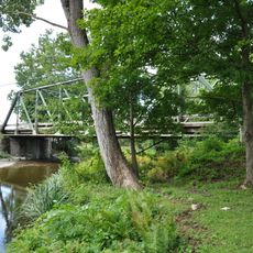
The Delaware and Hudson Rail Trail is a converted rail line that runs as a gravel path through rural Vermont countryside. It connects several small communities and features wooden bridges that cross streams throughout its length.

The rail line was built in the 1850s to transport slate from local quarries to market. It operated as a freight line for more than a century before closing and being converted to a public recreational path.

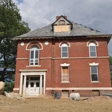
The trail runs through the Slate Valley, where you can see remnants of old quarries and industrial structures that shaped the region's identity. Local communities still connect to this mining heritage through the landscape you walk through.

You can access the trail from multiple points in several communities, making it easy to choose where to start your visit. The gravel surface works well for walking, cycling, and in winter conditions for cross-country skiing or snowmobiling.

The trail features 17 wooden bridges with railings that help you cross streams and valleys safely. These structures stand out as careful additions made when the old rail line was reopened for public use.

The community of curious travelers

AroundUs brings together thousands of curated places, local tips, and hidden gems, enriched daily by 60,000 contributors worldwide.

Start exploring
Location
GPS coordinates
43.55090,-73.22890
Latest update
December 13, 2025 17:03
Around this place
Wilson Castle
United States of America

Wilson Castle

17.5 km
Vermont Marble Museum
United States of America

Vermont Marble Museum

20 km
Devil's Bowl Speedway
United States of America

Devil's Bowl Speedway

14 km
Skene Manor
United States of America

Skene Manor

13.8 km
Castleton Medical College Building
United States of America

Castleton Medical College Building

7.7 km
William Miller Chapel and Ascension Rock
United States of America

William Miller Chapel and Ascension Rock

8.3 km
Half Moon Pond State Park
United States of America

Half Moon Pond State Park

16.5 km
Wilgus State Park
United States of America

Wilgus State Park

8.1 km
Clementwood
United States of America

Clementwood

18.7 km
Clarendon House
United States of America

Clarendon House

16.7 km
Main Street Historic District
United States of America

Main Street Historic District

14 km
Marble Bridge
United States of America

Marble Bridge

19.9 km
Fort Warren
United States of America

Fort Warren

8.6 km
South Street Bridge
United States of America

South Street Bridge

4.2 km
West Haven Baptist Church
United States of America

West Haven Baptist Church

14.7 km
West Rutland Town Hall
United States of America

West Rutland Town Hall

15.3 km
Dayton-Williams House
United States of America

Dayton-Williams House

13.8 km
Home Farm
United States of America

Home Farm

8.2 km
Watkins School
United States of America

Watkins School

19.8 km
Tinmouth Historic District
United States of America

Tinmouth Historic District

18.3 km
Asahel Kidder House
United States of America

Asahel Kidder House

3.8 km
Fair Haven Green Historic District
United States of America

Fair Haven Green Historic District

5.6 km
Pember Library and Museum
United States of America

Pember Library and Museum

16.3 km
Hydeville School
United States of America

Hydeville School

6.1 km
East Poultney Historic District
United States of America

East Poultney Historic District

3.4 km
Simeon Smith House
United States of America

Simeon Smith House

11.1 km
Marble Street Historic District
United States of America

Marble Street Historic District

15.4 km
Poultney Main Street Historic District
United States of America

Poultney Main Street Historic District

3.8 km
Show the full map
Reviews
Share your experience

No review yet

Discussions
Start a discussion...

No discussion yet

« Delaware and Hudson Rail Trail - Rail trail in western Rutland and Bennington Counties, Vermont, United States » is provided by Around Us (aroundus.com). Images and texts are derived from Wikimedia project under a Creative Commons license. You are allowed to copy, distribute, and modify copies of this page, under the conditions set by the license, as long as this note is clearly visible.

Discover hidden gems everywhere you go!

From secret cafés to breathtaking viewpoints, skip the crowded tourist spots and find places that match your style. Our app makes it easy with voice search, smart filtering, route optimization, and insider tips from travelers worldwide. Download now for the complete mobile experience.

Around Us App Screenshot

A unique approach to discovering new places

Le Figaro

All the places worth exploring

France Info

A tailor-made excursion in just a few clicks

20 Minutes

Around Us
Travel Guide & Maps
Download

Send to your phone

QR Code
1

Open the camera app on your mobile.

2

Point at the QR code with your camera. A notification will appear.

3

Tap the notification to open the link.