Erie National Wildlife Refuge

Log in to your account

AroundUs is a community-driven map of interesting places, built by curious explorers like you. It grows with every review, story, and photo you share.
Connect to save your favorite spots, contribute locations, and create personalized routes.
Continue with Google
Continue with Apple
Continue with X
Continue with Facebook
Continue with email
By continuing, you accept our Terms and Conditions and our Privacy Policy
Create an account

Erie National Wildlife Refuge

Add to collection
Map
Suggest a change
Share

Erie National Wildlife Refuge, National Wildlife Refuge in Crawford County, United States.

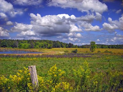
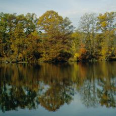
The Erie National Wildlife Refuge is a protected natural area in Crawford County, Pennsylvania, divided into two separate sections. The land contains wetlands, forests, beaver ponds, marsh habitats, and meadows crossed by several hiking trails.

The refuge was created in 1959 through funding from Duck Stamps, which hunters and conservation supporters purchased to protect migratory birds. This financing model allowed the refuge to be established and maintained over the decades.

The refuge takes its name from the Erie people, a Native American nation that lived in this Pennsylvania region long before Europeans arrived. Walking through the property today, visitors sense the deep roots this land holds in the region's indigenous past.

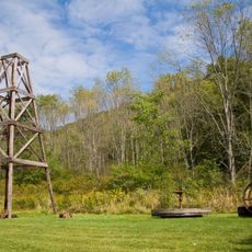
The property offers multiple walking trails of varying lengths, with some featuring boardwalks over wetlands while others cross open areas and forests. Visitors should wear sturdy footwear and come prepared for changing weather conditions, especially during wetter months.

The area is home to rare mussel species, including threatened freshwater types that survive in very few places worldwide. These mollusks are hard to spot but play a crucial role in filtering water and supporting the entire ecosystem.

Location: Crawford County

Inception: May 22, 1959

Website: https://fws.gov/refuge/erie

GPS coordinates: 41.62750,-79.96390

Latest update: December 12, 2025 09:05

Photos
Around this place
Conneaut Lake Park
United States of America

Conneaut Lake Park

29.2 km
Drake Well
United States of America

Drake Well

25.5 km
Drake Well Museum
United States of America

Drake Well Museum

25.5 km
Oil Creek State Park
United States of America

Oil Creek State Park

27.9 km
Fort Machault
United States of America

Fort Machault

29.4 km
John Brown Tannery Site
United States of America

John Brown Tannery Site

10.2 km
United States of America

Fort Venango

29 km
Maurice K. Goddard State Park
United States of America

Maurice K. Goddard State Park

26.8 km
United States of America

Baldwin-Reynolds House

15.8 km
Toboggan
United States of America

Toboggan

29.1 km
Samuel F. Dale House
United States of America

Samuel F. Dale House

27.7 km
Bentley Hall
United States of America

Bentley Hall

15.5 km
Independent Congregational Church
United States of America

Independent Congregational Church

15.5 km
Titusville City Hall
United States of America

Titusville City Hall

24.1 km
Amos Kelly House
United States of America

Amos Kelly House

20.9 km
Meadville Downtown Historic District
United States of America

Meadville Downtown Historic District

15.6 km
Jersey Bridge
United States of America

Jersey Bridge

25.5 km
Roueche House
United States of America

Roueche House

15.7 km
Bridge in Oil Creek Township
United States of America

Bridge in Oil Creek Township

21.7 km
Titusville Historic District
United States of America

Titusville Historic District

24.1 km
Ruter Hall
United States of America

Ruter Hall

15.4 km
Cambridge Springs Bridge
United States of America

Cambridge Springs Bridge

21.5 km
Franklin Historic District
United States of America

Franklin Historic District

28.3 km
Judge Henry Shippen House
United States of America

Judge Henry Shippen House

15.3 km
Edward Saeger House
United States of America

Edward Saeger House

18.4 km
Bridge in French Creek Township
United States of America

Bridge in French Creek Township

18 km
Bridge in Rockdale Township
United States of America

Bridge in Rockdale Township

20.4 km
Bridge over French Creek in West Mead Township
United States of America

Bridge over French Creek in West Mead Township

16.1 km
Show the full map
Reviews

Visited this place? Tap the stars to rate it and share your experience / photos with the community! Try now! You can cancel it anytime.

« Erie National Wildlife Refuge - National Wildlife Refuge in Crawford County, United States » is provided by Around Us (aroundus.com). Images and texts are derived from Wikimedia project under a Creative Commons license. You are allowed to copy, distribute, and modify copies of this page, under the conditions set by the license, as long as this note is clearly visible.

Discover hidden gems everywhere you go!

From secret cafés to breathtaking viewpoints, skip the crowded tourist spots and find places that match your style. Our app makes it easy with voice search, smart filtering, route optimization, and insider tips from travelers worldwide. Download now for the complete mobile experience.

Around Us App Screenshot

A unique approach to discovering new places

Le Figaro

All the places worth exploring

France Info

A tailor-made excursion in just a few clicks

20 Minutes