Enable Location

We need your location to show you interesting places around you

Discover nearby places

Find interesting locations and hidden gems around you

Precise directions

Get accurate directions and distances to places

Your location is never shared with other users. It's only used when you tap the location button.

Caracas-La Guaira highway

Log in to your account

Start exploring — it's free

Trusted by 63,122 travelers worldwide

Continue with Google
Continue with Apple
or

We will send you a code to connect

By continuing, you accept our Terms and Conditions and our Privacy Policy

Check your inbox

We've sent a pincode in your inbox. Please enter the code below.

Caracas-La Guaira highway
Discussion Reviews 1 Photos
11.8k Popularity

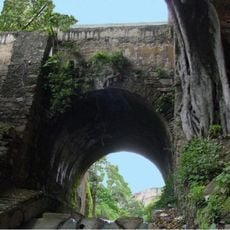
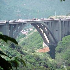
Caracas-La Guaira highway, Mountain highway between Caracas and La Guaira, Venezuela

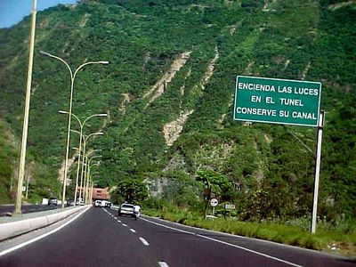
The Caracas-La Guaira highway is a four-lane mountain road with two tunnels and three concrete bridges connecting the capital to the port. This structure guides vehicles through steep slopes and allows direct passage over difficult terrain.

Construction started in 1950 and finished three years later, marking a turning point in the nation's transportation infrastructure. The completion showed Venezuela's commitment to building modern connections during a period of economic growth.

The road shaped how Venezuelans saw their nation's ability to build modern infrastructure and shows how oil wealth was invested in transportation progress. Travelers using it today can observe the engineering solutions that transformed movement between the capital and coast.

The road greatly reduces travel time between the capital and port and serves as the main route to the international airport. Keep in mind that mountain sections can be challenging in bad weather and require full attention while driving.

One tunnel crosses the mountain in a special way with two separate tubes, one for each direction of traffic. This dual-tube solution was a clever response to managing heavy traffic through the narrow mountain pass.

The community of curious travelers

AroundUs brings together thousands of curated places, local tips, and hidden gems, enriched daily by 60,000 contributors worldwide.

Start exploring
Location
Location
Inception
December 2, 1953
GPS coordinates
10.57736,-67.00220
Latest update
December 7, 2025 20:48
Reviews
Share your experience

No review yet

Discussions
Start a discussion...

No discussion yet

« Caracas-La Guaira highway - Mountain highway between Caracas and La Guaira, Venezuela » is provided by Around Us (aroundus.com). Images and texts are derived from Wikimedia project under a Creative Commons license. You are allowed to copy, distribute, and modify copies of this page, under the conditions set by the license, as long as this note is clearly visible.

Discover hidden gems everywhere you go!

From secret cafés to breathtaking viewpoints, skip the crowded tourist spots and find places that match your style. Our app makes it easy with voice search, smart filtering, route optimization, and insider tips from travelers worldwide. Download now for the complete mobile experience.

Around Us App Screenshot

A unique approach to discovering new places

Le Figaro

All the places worth exploring

France Info

A tailor-made excursion in just a few clicks

20 Minutes

Around Us
Travel Guide & Maps
Download

Send to your phone

QR Code
1

Open the camera app on your mobile.

2

Point at the QR code with your camera. A notification will appear.

3

Tap the notification to open the link.