Chest opened
+${chestReward.xp} XP
Explorer
NOUVEAU ×${chestReward.collectible.quantity}
tapez pour fermer
Chest locked

Open chests in the app

Around Us is built for your phone — chests unlock when you walk, explore and capture nearby places.

Enable Location

We need your location to show you interesting places around you

Discover nearby places

Find interesting locations and hidden gems around you

Precise directions

Get accurate directions and distances to places

Your location is never shared with other users. It's only used when you tap the location button.

Milwaukee River

Log in to your account

Start exploring — it's free

Trusted by 72,891 travelers worldwide

Continue with Google
Continue with Apple
or

We will send you a code to connect

By continuing, you accept our Terms and Conditions and our Privacy Policy

Check your inbox

We've sent a pincode in your inbox. Please enter the code below.

Milwaukee River
Discussion Reviews 1 Photos
14.1k Popularity

Milwaukee River, River system in southeastern Wisconsin, United States

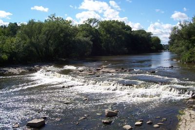
The Milwaukee River is a waterway that flows through southeastern Wisconsin and empties into Lake Michigan at Milwaukee harbor. It winds through different landscapes, from rural areas in the north to the heart of the city downstream.

Indigenous peoples such as the Ojibwa, Sauk, and Potawatomi lived along these banks for centuries, using the waterway for fishing and trade. When Europeans arrived in the region, the river became an important route for early settlers and fur traders.

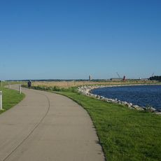
The river today serves as a gathering place where people walk, jog, and spend time outdoors. Parks and pathways along the water connect different parts of the city and give neighborhoods room to come together.

The riverwalk systems downtown make it easy to access the water for walking, jogging, and biking on most days. The river is also suitable for boating, with multiple public access points and launch areas spread along its length.

The waterway was heavily polluted for much of its history and interrupted by dams in places, but significant restoration work began in recent decades. Today it shows the results of cleanup efforts, with improved habitats and wildlife gradually returning to its banks.

The community of curious travelers

AroundUs brings together thousands of curated places, local tips, and hidden gems, enriched daily by 60,000 contributors worldwide.

Start exploring
Location
GPS coordinates
43.02557,-87.90286
Latest update
December 7, 2025 20:23
Around this place
U.S. Bank Center
United States of America

U.S. Bank Center

1.4 km
Hoan Bridge
United States of America

Hoan Bridge

329 m
Harley-Davidson Museum
United States of America

Harley-Davidson Museum

1.3 km
Rockwell Automation Headquarters
United States of America

Rockwell Automation Headquarters

1.1 km
Discovery World Science + Technology Center
United States of America

Discovery World Science + Technology Center

1.4 km
Milwaukee Public Market
United States of America

Milwaukee Public Market

1.2 km
Marcus Amphitheater
United States of America

Marcus Amphitheater

465 m
Henry Maier Festival Park
United States of America

Henry Maier Festival Park

426 m
Mitchell Building
United States of America

Mitchell Building

1.4 km
The Couture
United States of America

The Couture

1.3 km
Wisconsin Gas Building
United States of America

Wisconsin Gas Building

1.5 km
The Calling
United States of America

The Calling

1.5 km
Chase Tower
United States of America

Chase Tower

1.5 km
Milwaukee Pierhead Light
United States of America

Milwaukee Pierhead Light

617 m
National Bobblehead Hall of Fame and Museum
United States of America

National Bobblehead Hall of Fame and Museum

775 m
Federal Building
United States of America

Federal Building

1.4 km
411 East Wisconsin Center
United States of America

411 East Wisconsin Center

1.4 km
Lakeshore State Park
United States of America

Lakeshore State Park

945 m
Betty Brinn Children's Museum
United States of America

Betty Brinn Children's Museum

1.5 km
Reiman Bridge
United States of America

Reiman Bridge

1.6 km
St. Patrick's Roman Catholic Church
United States of America

St. Patrick's Roman Catholic Church

1.5 km
Holy Trinity Roman Catholic Church
United States of America

Holy Trinity Roman Catholic Church

1.1 km
Walker's Point Historic District
United States of America

Walker's Point Historic District

1.1 km
William F. Eisner Museum of Advertising & Design
United States of America

William F. Eisner Museum of Advertising & Design

943 m
Saint Stephen Evangelical Lutheran Church of Milwaukee
United States of America

Saint Stephen Evangelical Lutheran Church of Milwaukee

1.3 km
Erie Street Plaza
United States of America

Erie Street Plaza

94 m
Baumbach Building
United States of America

Baumbach Building

1 km
Gimbels Parking Pavilion
United States of America

Gimbels Parking Pavilion

1.5 km
Show the full map
Reviews
Share your experience

No review yet

Discussions
Start a discussion...

No discussion yet

« Milwaukee River - River system in southeastern Wisconsin, United States » is provided by Around Us (aroundus.com). Images and texts are derived from Wikimedia project under a Creative Commons license. You are allowed to copy, distribute, and modify copies of this page, under the conditions set by the license, as long as this note is clearly visible.

Discover hidden gems everywhere you go!

From secret cafés to breathtaking viewpoints, skip the crowded tourist spots and find places that match your style. Our app makes it easy with voice search, smart filtering, route optimization, and insider tips from travelers worldwide. Download now for the complete mobile experience.

Around Us App Screenshot

A unique approach to discovering new places

Le Figaro

All the places worth exploring

France Info

A tailor-made excursion in just a few clicks

20 Minutes

Around Us
Travel Guide & Maps
Download

Send to your phone

QR Code
1

Open the camera app on your mobile.

2

Point at the QR code with your camera. A notification will appear.

3

Tap the notification to open the link.