Enable Location

We need your location to show you interesting places around you

Discover nearby places

Find interesting locations and hidden gems around you

Precise directions

Get accurate directions and distances to places

Your location is never shared with other users. It's only used when you tap the location button.

Gooseberry Falls State Park

Log in to your account

Start exploring — it's free

Trusted by 62,954 travelers worldwide

Continue with Google
Continue with Apple
or

We will send you a code to connect

By continuing, you accept our Terms and Conditions and our Privacy Policy

Check your inbox

We've sent a pincode in your inbox. Please enter the code below.

Discussion Reviews 1 Photos
20.8k Popularity

Gooseberry Falls State Park, State park in Silver Creek Township, United States.

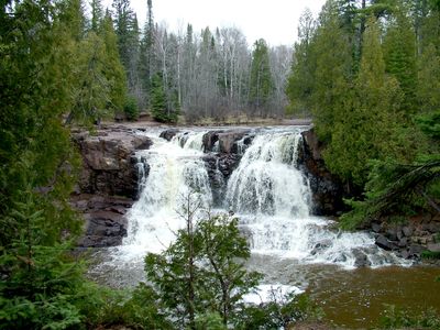
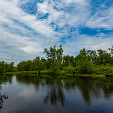
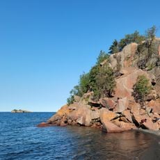
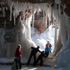
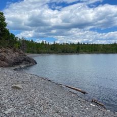
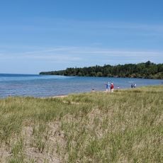
Gooseberry Falls State Park is a protected area along the shore of Lake Superior in Minnesota. The river cuts through ancient basalt layers and forms several cascades on its way to the lake, framed by wooded slopes and smooth rock ledges.

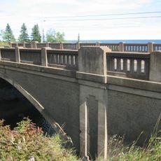
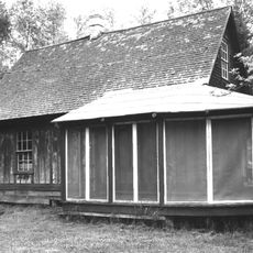
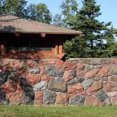
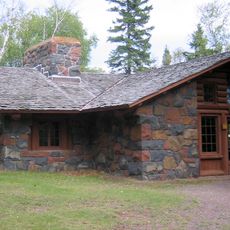
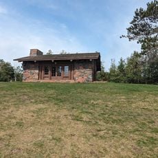
The park was created in the late 1930s when workers from the Civilian Conservation Corps laid out trails, built bridges and raised stone buildings. These efforts were part of a nationwide program during the economic crisis and shaped the way the place looks today.

The structures built during the 1930s use rough-hewn stone and timber in a style that matches the rugged character of the surrounding cliffs and forest. Visitors walk along paths and cross bridges that were laid out by hand, following routes that feel like natural extensions of the landscape.

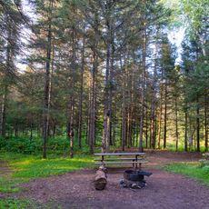
A network of about 18 miles (29 km) of trails connects the different waterfalls, the lakeshore, and the wooded slopes, and remains open year-round. Some paths follow level ground along the river, while others climb more steeply through the forest.

The five waterfalls of the Gooseberry River drop more than 100 feet (30 m) over a short distance, tumbling across dark basalt ledges. In some sections you can see the columnar structures of cooled lava rock in the riverbed.

The community of curious travelers

AroundUs brings together thousands of curated places, local tips, and hidden gems, enriched daily by 60,000 contributors worldwide.

Start exploring
Inception
1937
Operator
Minnesota Department of Natural Resources
Address
3206 Highway 61 East, Two Harbors, MN 55616
Phone
GPS coordinates
47.14694,-91.46333
Latest update
December 5, 2025 22:28
Around this place
Split Rock Lighthouse
United States of America

Split Rock Lighthouse

9.4 km
Tettegouche State Park
United States of America

Tettegouche State Park

29 km
Split Rock Lighthouse State Park
United States of America

Split Rock Lighthouse State Park

7.3 km
Edna G
United States of America

Edna G

21.5 km
Two Harbors Lighthouse
United States of America

Two Harbors Lighthouse

21.2 km
John Dwan Office Building
United States of America

John Dwan Office Building

21.1 km
Finland State Forest
United States of America

Finland State Forest

41.7 km
Cloquet Valley State Forest
United States of America

Cloquet Valley State Forest

43.5 km
Sand Island Light
United States of America

Sand Island Light

43 km
Black Beach
United States of America

Black Beach

23.2 km
Two Harbors Breakwater Light
United States of America

Two Harbors Breakwater Light

21.8 km
Lake County Courthouse and Sheriff's Residence
United States of America

Lake County Courthouse and Sheriff's Residence

21 km
Bridge No. 3589
United States of America

Bridge No. 3589

16.7 km
Sevona Cabin
United States of America

Sevona Cabin

44.8 km
Two Harbors Carnegie Library
United States of America

Two Harbors Carnegie Library

21 km
Herbster Community Center
United States of America

Herbster Community Center

38.4 km
North Shore Adventure Park
United States of America

North Shore Adventure Park

22.7 km
Apostle Islands Ice Caves
United States of America

Apostle Islands Ice Caves

43 km
Gooseberry Falls State Park CCC/WPA/Rustic Style Historic Resources
United States of America

Gooseberry Falls State Park CCC/WPA/Rustic Style Historic Resources

694 m
Pebble Beach
United States of America

Pebble Beach

8.6 km
Corny Beach
United States of America

Corny Beach

42.3 km
Finland Lookout Tower
United States of America

Finland Lookout Tower

38.6 km
Lady Slipper Lodge
United States of America

Lady Slipper Lodge

694 m
Split Rock Lighthouse Overlook
United States of America

Split Rock Lighthouse Overlook

8.6 km
Molde Lookout Tower
United States of America

Molde Lookout Tower

31.5 km
Agate Beach
United States of America

Agate Beach

669 m
Flood Bay
United States of America

Flood Bay

18.3 km
Beaver River Beach
United States of America

Beaver River Beach

18 km
Show the full map
Reviews
Share your experience

No review yet

Discussions
Start a discussion...

No discussion yet

« Gooseberry Falls State Park - State park in Silver Creek Township, United States » is provided by Around Us (aroundus.com). Images and texts are derived from Wikimedia project under a Creative Commons license. You are allowed to copy, distribute, and modify copies of this page, under the conditions set by the license, as long as this note is clearly visible.

Discover hidden gems everywhere you go!

From secret cafés to breathtaking viewpoints, skip the crowded tourist spots and find places that match your style. Our app makes it easy with voice search, smart filtering, route optimization, and insider tips from travelers worldwide. Download now for the complete mobile experience.

Around Us App Screenshot

A unique approach to discovering new places

Le Figaro

All the places worth exploring

France Info

A tailor-made excursion in just a few clicks

20 Minutes

Around Us
Travel Guide & Maps
Download

Send to your phone

QR Code
1

Open the camera app on your mobile.

2

Point at the QR code with your camera. A notification will appear.

3

Tap the notification to open the link.