Enable Location

We need your location to show you interesting places around you

Discover nearby places

Find interesting locations and hidden gems around you

Precise directions

Get accurate directions and distances to places

Your location is never shared with other users. It's only used when you tap the location button.

Hennepin Avenue Bridge

Log in to your account

Start exploring — it's free

Trusted by 61,477 travelers worldwide

Continue with Google
Continue with Apple
or

We will send you a code to connect

By continuing, you accept our Terms and Conditions and our Privacy Policy

Check your inbox

We've sent a pincode in your inbox. Please enter the code below.

Hennepin Avenue Bridge

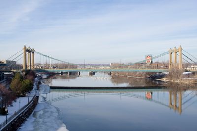
Hennepin Avenue Bridge, Suspension bridge in downtown Minneapolis, United States.

Description

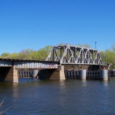
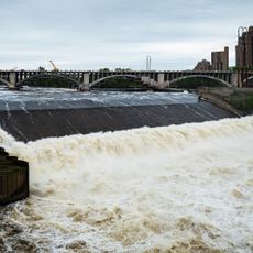
The Hennepin Avenue Bridge is a suspension bridge crossing the Mississippi River in downtown Minneapolis, connecting the city center with Nicollet Island. The structure accommodates six traffic lanes alongside dedicated pathways for pedestrians and cyclists.

History

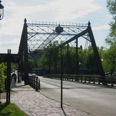
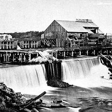
The first bridge at this location opened in 1855 as one of the earliest permanent crossings over the Mississippi in the United States. The current structure, finished in 1990, replaced earlier versions that had spanned the river at the same site.

Culture

The bridge takes its name from Father Louis Hennepin, a 17th-century explorer who documented the Saint Anthony Falls downstream during his travels on the Mississippi. His connection to the river and the falls remains woven into the place's identity today.

Practical

The bridge maintains roughly 11 meters of clearance above the water, allowing river traffic to pass underneath continuously. Access is straightforward from all directions, and crossing on foot or by bicycle is simple and direct.

Did you know?

The current bridge is the fourth crossing built at this exact location, following two earlier suspension bridges and a steel arch structure. This succession reveals how the city continuously adapted to changing traffic demands and construction methods over time.

Location
Inception
1990
Official opening
1990
Length
316 m
GPS coordinates
44.98530,-93.26390
Latest update
December 9, 2025 18:44

AroundUs brings together thousands of curated places, local tips, and hidden gems, enriched daily by 60,000 contributors worldwide. Discover all places nearby (Minneapolis).

Around this place
Saint Anthony Falls
United States of America

Saint Anthony Falls

580 m
Mill City Museum
United States of America

Mill City Museum

847 m
Nicollet Island
United States of America

Nicollet Island

249 m
Metropolitan Building
United States of America

Metropolitan Building

678 m
Northwestern National Life Building
United States of America

Northwestern National Life Building

491 m
Mill Ruins Park
United States of America

Mill Ruins Park

729 m
Minneapolis Central Library
United States of America

Minneapolis Central Library

714 m
Marquette Plaza
United States of America

Marquette Plaza

578 m
Our Lady of Lourdes Catholic Church
United States of America

Our Lady of Lourdes Catholic Church

527 m
100 Washington Square
United States of America

100 Washington Square

491 m
Third Avenue Bridge
United States of America

Third Avenue Bridge

452 m
The Carlyle
United States of America

The Carlyle

384 m
Industrial Exposition Building
United States of America

Industrial Exposition Building

570 m
Churchill Apartments
United States of America

Churchill Apartments

313 m
Hennepin Island Hydroelectric Plant
United States of America

Hennepin Island Hydroelectric Plant

829 m
Ceresota Building
United States of America

Ceresota Building

703 m
Minneapolis BNSF Rail Bridge
United States of America

Minneapolis BNSF Rail Bridge

316 m
Traffic Zone Center for Visual Art
United States of America

Traffic Zone Center for Visual Art

849 m
La Rive Condominiums
United States of America

La Rive Condominiums

507 m
Globe Building
United States of America

Globe Building

752 m
Flour Exchange Building
United States of America

Flour Exchange Building

722 m
Farmers and Mechanics Savings Bank
United States of America

Farmers and Mechanics Savings Bank

808 m
Merriam Street Bridge
United States of America

Merriam Street Bridge

361 m
Minnesota Planetarium
United States of America

Minnesota Planetarium

757 m
Upper Saint Anthony Falls
United States of America

Upper Saint Anthony Falls

465 m
Saint Anthony Falls Upper Lock and Dam
United States of America

Saint Anthony Falls Upper Lock and Dam

580 m
Saint Anthony Falls Historic District
United States of America

Saint Anthony Falls Historic District

503 m
St. Anthony Main Theatre
United States of America

St. Anthony Main Theatre

657 m
Show the full map
« Hennepin Avenue Bridge - Suspension bridge in downtown Minneapolis, United States » is provided by Around Us (aroundus.com). Images and texts are derived from Wikimedia project under a Creative Commons license. You are allowed to copy, distribute, and modify copies of this page, under the conditions set by the license, as long as this note is clearly visible.

Discover hidden gems everywhere you go!

From secret cafés to breathtaking viewpoints, skip the crowded tourist spots and find places that match your style. Our app makes it easy with voice search, smart filtering, route optimization, and insider tips from travelers worldwide. Download now for the complete mobile experience.

Around Us App Screenshot

A unique approach to discovering new places

Le Figaro

All the places worth exploring

France Info

A tailor-made excursion in just a few clicks

20 Minutes

Around Us
Travel Guide & Maps
Download

Send to your phone

QR Code
1

Open the camera app on your mobile.

2

Point at the QR code with your camera. A notification will appear.

3

Tap the notification to open the link.