Enable Location

We need your location to show you interesting places around you

Discover nearby places

Find interesting locations and hidden gems around you

Precise directions

Get accurate directions and distances to places

Your location is never shared with other users. It's only used when you tap the location button.

Hennepin Island Hydroelectric Plant

Log in to your account

Start exploring — it's free

Trusted by 61,507 travelers worldwide

Continue with Google
Continue with Apple
or

We will send you a code to connect

By continuing, you accept our Terms and Conditions and our Privacy Policy

Check your inbox

We've sent a pincode in your inbox. Please enter the code below.

Hennepin Island Hydroelectric Plant

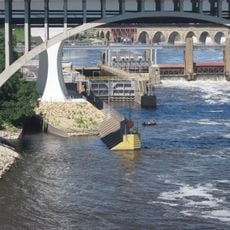
Hennepin Island Hydroelectric Plant, Hydroelectric power station at St. Anthony Falls, Minneapolis, United States

Description

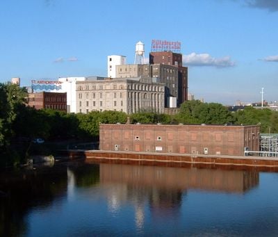
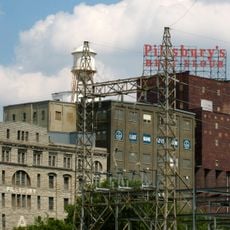
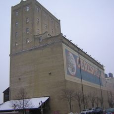
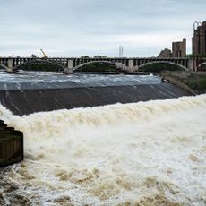
Hennepin Island Hydroelectric Plant is a power station located on the Mississippi River at St. Anthony Falls, using the river's natural water flow to produce electricity. The facility contains five generating units housed within a substantial industrial brick structure built directly on an island in the river.

History

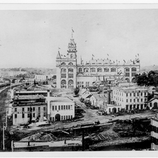
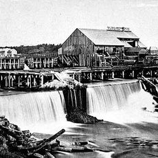
The plant was designed in the early 1900s by William de la Barre, an Austrian-born engineer, as part of Minneapolis industrial expansion. It became part of the region's shift toward harnessing the water power available at St. Anthony Falls for urban energy needs.

Culture

The facility stands as a National Register of Historic Places contributing property within the St. Anthony Falls Historic District, representing industrial engineering excellence.

Practical

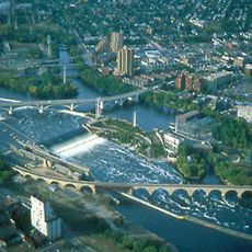
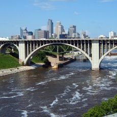
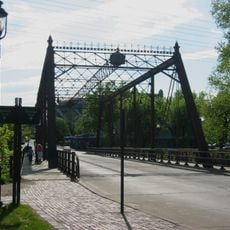
The site is located on an island with public walkways that offer views of the falls and surrounding landscape. Visitors can observe the exterior of the facility and the river's flow, which is most impressive during periods of higher water level.

Did you know?

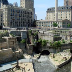
The facility shares Hennepin Island with Water Power Park, where visitors can explore exhibits about local hydroelectric history and industrial heritage. The park includes educational displays and information stations that explain how the falls powered Minneapolis industrial development.

Location
Architects
William de la Barre
GPS coordinates
44.98240,-93.25420
Latest update
December 14, 2025 09:45

AroundUs brings together thousands of curated places, local tips, and hidden gems, enriched daily by 60,000 contributors worldwide. Discover all places nearby (Minneapolis).

Around this place
Saint Anthony Falls
United States of America

Saint Anthony Falls

357 m
Guthrie Theater
United States of America

Guthrie Theater

486 m
Stone Arch Bridge
United States of America

Stone Arch Bridge

184 m
I-35W Saint Anthony Falls Bridge
United States of America

I-35W Saint Anthony Falls Bridge

823 m
Mill City Museum
United States of America

Mill City Museum

405 m
Nicollet Island
United States of America

Nicollet Island

916 m
Pillsbury A Mill
United States of America

Pillsbury A Mill

210 m
Mill Ruins Park
United States of America

Mill Ruins Park

365 m
Hennepin Avenue Bridge
United States of America

Hennepin Avenue Bridge

829 m
Our Lady of Lourdes Catholic Church
United States of America

Our Lady of Lourdes Catholic Church

551 m
10th Avenue Bridge
United States of America

10th Avenue Bridge

901 m
Third Avenue Bridge
United States of America

Third Avenue Bridge

383 m
The Carlyle
United States of America

The Carlyle

703 m
Industrial Exposition Building
United States of America

Industrial Exposition Building

427 m
Gold Medal Park
United States of America

Gold Medal Park

552 m
Churchill Apartments
United States of America

Churchill Apartments

851 m
Ceresota Building
United States of America

Ceresota Building

527 m
La Rive Condominiums
United States of America

La Rive Condominiums

459 m
Merriam Street Bridge
United States of America

Merriam Street Bridge

565 m
Horatio P. Van Cleve House
United States of America

Horatio P. Van Cleve House

796 m
Woodbury Fisk House
United States of America

Woodbury Fisk House

650 m
Upper Saint Anthony Falls
United States of America

Upper Saint Anthony Falls

401 m
Saint Anthony Falls Upper Lock and Dam
United States of America

Saint Anthony Falls Upper Lock and Dam

357 m
Saint Anthony Falls Historic District
United States of America

Saint Anthony Falls Historic District

355 m
St. Anthony Main Theatre
United States of America

St. Anthony Main Theatre

279 m
Hennepin Island Park
United States of America

Hennepin Island Park

222 m
Saint Anthony Falls Lower Lock and Dam
United States of America

Saint Anthony Falls Lower Lock and Dam

729 m
Nicollet Island Park
United States of America

Nicollet Island Park

578 m
Show the full map
« Hennepin Island Hydroelectric Plant - Hydroelectric power station at St. Anthony Falls, Minneapolis, United States » is provided by Around Us (aroundus.com). Images and texts are derived from Wikimedia project under a Creative Commons license. You are allowed to copy, distribute, and modify copies of this page, under the conditions set by the license, as long as this note is clearly visible.

Discover hidden gems everywhere you go!

From secret cafés to breathtaking viewpoints, skip the crowded tourist spots and find places that match your style. Our app makes it easy with voice search, smart filtering, route optimization, and insider tips from travelers worldwide. Download now for the complete mobile experience.

Around Us App Screenshot

A unique approach to discovering new places

Le Figaro

All the places worth exploring

France Info

A tailor-made excursion in just a few clicks

20 Minutes

Around Us
Travel Guide & Maps
Download

Send to your phone

QR Code
1

Open the camera app on your mobile.

2

Point at the QR code with your camera. A notification will appear.

3

Tap the notification to open the link.