Enable Location

We need your location to show you interesting places around you

Discover nearby places

Find interesting locations and hidden gems around you

Precise directions

Get accurate directions and distances to places

Your location is never shared with other users. It's only used when you tap the location button.

Baraboo Range

Log in to your account

Start exploring — it's free

Trusted by 62,058 travelers worldwide

Continue with Google
Continue with Apple
or

We will send you a code to connect

By continuing, you accept our Terms and Conditions and our Privacy Policy

Check your inbox

We've sent a pincode in your inbox. Please enter the code below.

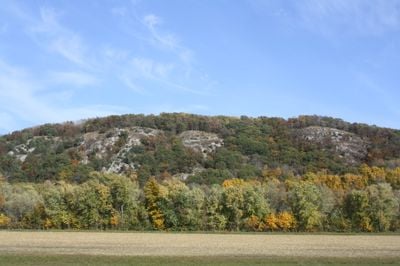
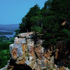
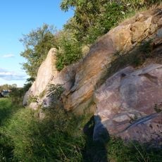
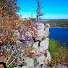
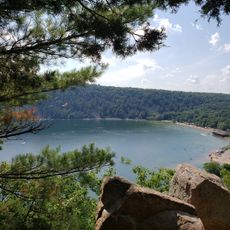
Baraboo Range, Inselberg in Columbia County, Wisconsin, US.

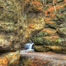
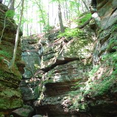
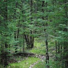
Baraboo Range is a striking ridge of hard rock that cuts across the landscape between two counties, with forested slopes and rocky outcrops visible throughout. The terrain features a series of elongated ridges and valleys that create a dramatic topography quite different from the flat surroundings.

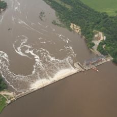
The ridge formed around 1.7 billion years ago when ancient sediments transformed into hard quartzite through intense pressure and heat. Glaciers later sculpted the eastern slopes while the western portion escaped glaciation, creating a marked landscape boundary.

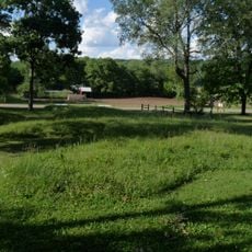
The Nature Conservancy manages multiple preserves within the range, including Baxter's Hollow and Hemlock Draw, protecting 9,844 acres of natural habitat.

The area offers numerous hiking trails at varying difficulty levels that lead through forests and across ridges for different experience levels. Year-round exploration is possible, though spring and fall provide the most comfortable conditions for outdoor activity.

The western end of the ridge shows no signs of glacial sanding and preserves habitats that have remained unchanged for millions of years. This contrast between polished and untouched sections makes the location important for understanding ice age history.

The community of curious travelers

AroundUs brings together thousands of curated places, local tips, and hidden gems, enriched daily by 60,000 contributors worldwide.

Start exploring
Location
Location
GPS coordinates
43.42500,-89.65560
Latest update
December 8, 2025 19:43
Around this place
Devil's Lake State Park
United States of America

Devil's Lake State Park

4.8 km
Badger Army Ammunition Plant
United States of America

Badger Army Ammunition Plant

10.2 km
Circus World Museum
United States of America

Circus World Museum

7.6 km
Forevertron
United States of America

Forevertron

11.6 km
Lake Wisconsin
United States of America

Lake Wisconsin

14 km
International Clown Hall of Fame
United States of America

International Clown Hall of Fame

8.7 km
Aldo Leopold Shack and Farm
United States of America

Aldo Leopold Shack and Farm

15.3 km
Pewits Nest State Natural Area
United States of America

Pewits Nest State Natural Area

11.2 km
Parfrey's Glen State Natural Area
United States of America

Parfrey's Glen State Natural Area

1.4 km
Gibraltar Rock State Natural Area
United States of America

Gibraltar Rock State Natural Area

9.6 km
Man Mound
United States of America

Man Mound

7.2 km
Al. Ringling Theatre
United States of America

Al. Ringling Theatre

8.8 km
Durward's Glen
United States of America

Durward's Glen

5.2 km
Point of Rocks
United States of America

Point of Rocks

9.5 km
Walworth D. Porter Duplex Residence
United States of America

Walworth D. Porter Duplex Residence

8.7 km
Sauk County Courthouse
United States of America

Sauk County Courthouse

8.7 km
John A. and Martha Robertson House
United States of America

John A. and Martha Robertson House

15.5 km
Manchester Street Bridge
United States of America

Manchester Street Bridge

9.6 km
Charles Ringling House
United States of America

Charles Ringling House

8.8 km
Baraboo Public Library
United States of America

Baraboo Public Library

8.9 km
Richard W. and Margaret Mills House
United States of America

Richard W. and Margaret Mills House

15.9 km
William Clark House
United States of America

William Clark House

8.1 km
Frank T. and Polly Lewis House
United States of America

Frank T. and Polly Lewis House

15.6 km
Island Woolen Company Office Building
United States of America

Island Woolen Company Office Building

9.6 km
Ice Age Trail
United States of America

Ice Age Trail

5.5 km
Bonham Theatre & Video
United States of America

Bonham Theatre & Video

15.8 km
West Bluff
United States of America

West Bluff

6.6 km
North Shore Beach
United States of America

North Shore Beach

6.3 km
Show the full map
« Baraboo Range - Inselberg in Columbia County, Wisconsin, US » is provided by Around Us (aroundus.com). Images and texts are derived from Wikimedia project under a Creative Commons license. You are allowed to copy, distribute, and modify copies of this page, under the conditions set by the license, as long as this note is clearly visible.

Discover hidden gems everywhere you go!

From secret cafés to breathtaking viewpoints, skip the crowded tourist spots and find places that match your style. Our app makes it easy with voice search, smart filtering, route optimization, and insider tips from travelers worldwide. Download now for the complete mobile experience.

Around Us App Screenshot

A unique approach to discovering new places

Le Figaro

All the places worth exploring

France Info

A tailor-made excursion in just a few clicks

20 Minutes

Around Us
Travel Guide & Maps
Download

Send to your phone

QR Code
1

Open the camera app on your mobile.

2

Point at the QR code with your camera. A notification will appear.

3

Tap the notification to open the link.