Chest opened
+${chestReward.xp} XP
Explorer
NOUVEAU ×${chestReward.collectible.quantity}
tapez pour fermer
Chest locked

Open chests in the app

Around Us is built for your phone — chests unlock when you walk, explore and capture nearby places.

Enable Location

We need your location to show you interesting places around you

Discover nearby places

Find interesting locations and hidden gems around you

Precise directions

Get accurate directions and distances to places

Your location is never shared with other users. It's only used when you tap the location button.

U.S. Route 301 in Maryland

Log in to your account

Start exploring — it's free

Trusted by 73,013 travelers worldwide

Continue with Google
Continue with Apple
or

We will send you a code to connect

By continuing, you accept our Terms and Conditions and our Privacy Policy

Check your inbox

We've sent a pincode in your inbox. Please enter the code below.

Discussion Reviews 1 Photos
18.5k Popularity

U.S. Route 301 in Maryland, highway in Maryland

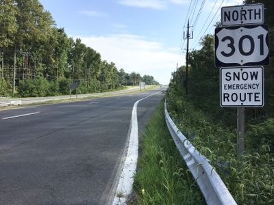
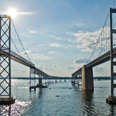
US Route 301 in Maryland is a north-south highway stretching about 123 miles from the Virginia border at the Harry W. Nice Bridge to the Delaware border, passing through six counties. The road runs through rural and suburban areas, connecting towns like La Plata, Waldorf, and Bowie with multi-lane sections and bridge crossings over rivers and the Chesapeake Bay.

The route opened originally in 1927 as Maryland Route 3 and was developed with the effort of Robert Crain, a lawyer and farmer who pushed for the road's completion. In the 1940s, the Harry W. Nice Bridge was built to connect the route to Virginia and establish US Route 301.

US Route 301 in Maryland is part of the Blue Star Memorial Highway network honoring those who served in the military. The road connects small towns and farming communities, showing how the region developed over time.

The road has various sections with different conditions, ranging from simple country roads to four-lane freeways, especially near cities like Bowie and toward the Delaware border. Drivers should note that some sections include tolls, particularly when heading into Delaware, and traffic can be heavy in suburban and urban areas.

Robert Crain, the farmer and lawyer to whom the original road was dedicated, played a key role in getting the project realized in the 1920s. A new bridge recently replaced the historic Harry W. Nice Bridge, a project completed in 2022 that modernized the connection between Maryland and Virginia.

The community of curious travelers

AroundUs brings together thousands of curated places, local tips, and hidden gems, enriched daily by 60,000 contributors worldwide.

Start exploring
Location
Location
Location
Location
Inception
1940
Part of
U.S. Route 301
GPS coordinates
38.99176,-76.37069
Latest update
February 16, 2026 23:41
Reviews
Share your experience

No review yet

Discussions
Start a discussion...

No discussion yet

« U.S. Route 301 in Maryland - highway in Maryland » is provided by Around Us (aroundus.com). Images and texts are derived from Wikimedia project under a Creative Commons license. You are allowed to copy, distribute, and modify copies of this page, under the conditions set by the license, as long as this note is clearly visible.

Discover hidden gems everywhere you go!

From secret cafés to breathtaking viewpoints, skip the crowded tourist spots and find places that match your style. Our app makes it easy with voice search, smart filtering, route optimization, and insider tips from travelers worldwide. Download now for the complete mobile experience.

Around Us App Screenshot

A unique approach to discovering new places

Le Figaro

All the places worth exploring

France Info

A tailor-made excursion in just a few clicks

20 Minutes

Around Us
Travel Guide & Maps
Download

Send to your phone

QR Code
1

Open the camera app on your mobile.

2

Point at the QR code with your camera. A notification will appear.

3

Tap the notification to open the link.