Chest opened
+${chestReward.xp} XP
Explorer
NOUVEAU ×${chestReward.collectible.quantity}
tapez pour fermer
Chest locked

Open chests in the app

Around Us is built for your phone — chests unlock when you walk, explore and capture nearby places.

Enable Location

We need your location to show you interesting places around you

Discover nearby places

Find interesting locations and hidden gems around you

Precise directions

Get accurate directions and distances to places

Your location is never shared with other users. It's only used when you tap the location button.

Parrottsville

Log in to your account

Start exploring — it's free

Trusted by 72,877 travelers worldwide

Continue with Google
Continue with Apple
or

We will send you a code to connect

By continuing, you accept our Terms and Conditions and our Privacy Policy

Check your inbox

We've sent a pincode in your inbox. Please enter the code below.

Discussion Reviews 1 Photos
12.1k Popularity

Parrottsville, Administrative town in Cocke County, Tennessee, United States.

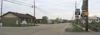
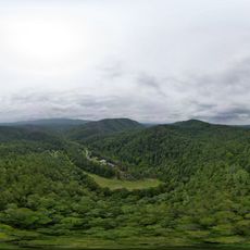
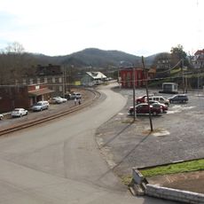
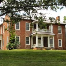
Parrottsville is a small town in Cocke County in northeastern Tennessee, situated along U.S. Route 321 between Newport and Greeneville. The community features a compact rural setting with local businesses, residences, and Town Hall serving as the administrative center.

The settlement was founded in 1769 and named after early settler John Parrott. It was officially incorporated as a municipality in 1923.

The town maintains its local governance traditions through monthly public meetings at Town Hall, where residents participate in community decision-making processes.

Town Hall serves as the central point for local government services and is located in the heart of the community. Visitors can find information about municipal services and local matters there.

The population has decreased from 263 residents in 2010 to 217 in 2024, according to Tennessee Department of Economic and Community Development records.

The community of curious travelers

AroundUs brings together thousands of curated places, local tips, and hidden gems, enriched daily by 60,000 contributors worldwide.

Start exploring
GPS coordinates
36.00927,-83.09238
Latest update
December 7, 2025 20:47
Around this place
Max Patch
United States of America

Max Patch

26.6 km
Andrew Johnson National Cemetery
United States of America

Andrew Johnson National Cemetery

28.1 km
Morristown College
United States of America

Morristown College

29.7 km
Forbidden Caverns
United States of America

Forbidden Caverns

25.7 km
Bush's Visitor Center
United States of America

Bush's Visitor Center

24 km
Crockett Tavern Museum
United States of America

Crockett Tavern Museum

28.4 km
Tyson McCarter Place
United States of America

Tyson McCarter Place

33.6 km
Maddron Bald Trail
United States of America

Maddron Bald Trail

31 km
United States of America

Morristown Main Street Historic District

29 km
Rose Center
United States of America

Rose Center

29.3 km
Snake Den Ridge Trail
United States of America

Snake Den Ridge Trail

30.4 km
Fairfax
United States of America

Fairfax

15.8 km
Greeneville Historic District
United States of America

Greeneville Historic District

29.1 km
Bethesda Presbyterian Church
United States of America

Bethesda Presbyterian Church

29.2 km
Foxfire Mountain Themed Adventure Park
United States of America

Foxfire Mountain Themed Adventure Park

33.6 km
Swaggerty Blockhouse
United States of America

Swaggerty Blockhouse

2 km
United States of America

Lower Mount Cammerer Trail

30.4 km
Bulls Gap Historic District
United States of America

Bulls Gap Historic District

27.1 km
Conway Bridge
United States of America

Conway Bridge

13.1 km
Rural Mount
United States of America

Rural Mount

17.5 km
Hamblen County Courthouse
United States of America

Hamblen County Courthouse

29.2 km
Lawson D. Franklin House
United States of America

Lawson D. Franklin House

17.4 km
Squirewood Hall
United States of America

Squirewood Hall

29.7 km
Sunnybank
United States of America

Sunnybank

27.1 km
Waterfall on West Prong Hickey Fork
United States of America

Waterfall on West Prong Hickey Fork

33.8 km
St. Paul Presbyterian Church
United States of America

St. Paul Presbyterian Church

20.8 km
Mount Cammerer Fire Lookout
United States of America

Mount Cammerer Fire Lookout

28.1 km
Mount Sterling Tower
United States of America

Mount Sterling Tower

34.3 km
Show the full map
Reviews
Share your experience

No review yet

Discussions
Start a discussion...

No discussion yet

« Parrottsville - Administrative town in Cocke County, Tennessee, United States » is provided by Around Us (aroundus.com). Images and texts are derived from Wikimedia project under a Creative Commons license. You are allowed to copy, distribute, and modify copies of this page, under the conditions set by the license, as long as this note is clearly visible.

Discover hidden gems everywhere you go!

From secret cafés to breathtaking viewpoints, skip the crowded tourist spots and find places that match your style. Our app makes it easy with voice search, smart filtering, route optimization, and insider tips from travelers worldwide. Download now for the complete mobile experience.

Around Us App Screenshot

A unique approach to discovering new places

Le Figaro

All the places worth exploring

France Info

A tailor-made excursion in just a few clicks

20 Minutes

Around Us
Travel Guide & Maps
Download

Send to your phone

QR Code
1

Open the camera app on your mobile.

2

Point at the QR code with your camera. A notification will appear.

3

Tap the notification to open the link.