Columbia–Wrightsville Bridge

Log in to your account

AroundUs is a community-driven map of interesting places, built by curious explorers like you. It grows with every review, story, and photo you share.
Connect to save your favorite spots, contribute locations, and create personalized routes.
By continuing, you accept our Terms and Conditions and our Privacy Policy
Add to collection
Map
Suggest a change
Share

Columbia–Wrightsville Bridge, Deck arch bridge in Wrightsville, United States

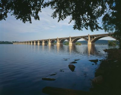
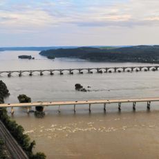
The Columbia–Wrightsville Bridge is a reinforced concrete deck arch structure that crosses the Susquehanna River and links the towns of Columbia and Wrightsville. The structure features 27 river piers and 22 approach piers supporting a roadway approximately 38 feet wide.

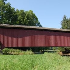
The current structure was completed in 1930, replacing earlier bridges at the site including the world's longest covered bridge erected in 1814. This rebuilding addressed growing transportation needs in the region during the early twentieth century.

The bridge received its Veterans Memorial designation in 1980, becoming a symbol of local pride in honoring military service. This naming reflects how the communities on both sides have chosen to acknowledge their connection to the region's past.

The bridge serves Pennsylvania Route 462 and BicyclePA Route S, accommodating both vehicles and people on foot. Visitors should use the marked routes for access, and it is worth knowing that traffic can be heavy during peak hours.

Engineers recognize this structure as the world's longest concrete multi-arch bridge, with average spans of roughly 185 feet between arches. This distinction reflects early twentieth-century construction innovations and remains of technical interest to engineering professionals.

Location: Wrightsville

Location: Columbia

Inception: 1930

Official opening: September 30, 1930

Length: 2,029 m

GPS coordinates: 40.02900,-76.51700

Latest update: December 8, 2025 19:57

Photos
Around this place
Chickies Ridge
United States of America

Chickies Ridge

2.6 km
Samuel S. Lewis State Park
United States of America

Samuel S. Lewis State Park

4.6 km
Cameron Estate
United States of America

Cameron Estate

9.3 km
Wright's Ferry Bridge
United States of America

Wright's Ferry Bridge

932 m
Siegrist's Mill Covered Bridge
United States of America

Siegrist's Mill Covered Bridge

6.5 km
Donegal Presbyterian Church Complex
United States of America

Donegal Presbyterian Church Complex

9.1 km
Donegal Mills Plantation
United States of America

Donegal Mills Plantation

6.5 km
Wright's Ferry Mansion
United States of America

Wright's Ferry Mansion

1.2 km
Forry's Mill Covered Bridge
United States of America

Forry's Mill Covered Bridge

5.3 km
Columbia Historic District
United States of America

Columbia Historic District

1.3 km
Dritt Mansion
United States of America

Dritt Mansion

6 km
Marietta Historic District (Marietta, Pennsylvania)
United States of America

Marietta Historic District (Marietta, Pennsylvania)

4.6 km
Byers-Muma House
United States of America

Byers-Muma House

7.1 km
Chickies Historic District
United States of America

Chickies Historic District

4.7 km
Grove Mansion
United States of America

Grove Mansion

7.2 km
Martin Schultz House
United States of America

Martin Schultz House

8.5 km
Byrd Leibhart Site
United States of America

Byrd Leibhart Site

5.9 km
Linden House
United States of America

Linden House

4 km
Strickler Site
United States of America

Strickler Site

7.2 km
Bachman and Forry Tobacco Warehouse
United States of America

Bachman and Forry Tobacco Warehouse

1.1 km
Burgholtshouse
United States of America

Burgholtshouse

7 km
Frey-Haverstick Site
United States of America

Frey-Haverstick Site

5.5 km
George Brown's Sons Cotton and Woolen Mill
United States of America

George Brown's Sons Cotton and Woolen Mill

9.1 km
Murry Site
United States of America

Murry Site

7.8 km
Manor Street Elementary School
United States of America

Manor Street Elementary School

2.3 km
Shultz-Funk Site
United States of America

Shultz-Funk Site

8.6 km
Wrightsville Historic District
United States of America

Wrightsville Historic District

1.1 km
National Watch and Clock Museum
United States of America

National Watch and Clock Museum

1.6 km
Show the full map
Reviews

Visited this place? Tap the stars to rate it and share your experience / photos with the community! Try now! You can cancel it anytime.

« Columbia–Wrightsville Bridge - Deck arch bridge in Wrightsville, United States » is provided by Around Us (aroundus.com). Images and texts are derived from Wikimedia project under a Creative Commons license. You are allowed to copy, distribute, and modify copies of this page, under the conditions set by the license, as long as this note is clearly visible.

Discover hidden gems everywhere you go!

From secret cafés to breathtaking viewpoints, skip the crowded tourist spots and find places that match your style. Our app makes it easy with voice search, smart filtering, route optimization, and insider tips from travelers worldwide. Download now for the complete mobile experience.

Around Us App Screenshot

A unique approach to discovering new places

Le Figaro

All the places worth exploring

France Info

A tailor-made excursion in just a few clicks

20 Minutes