Enable Location

We need your location to show you interesting places around you

Discover nearby places

Find interesting locations and hidden gems around you

Precise directions

Get accurate directions and distances to places

Your location is never shared with other users. It's only used when you tap the location button.

Forry's Mill Covered Bridge

Log in to your account

Start exploring — it's free

Trusted by 61,578 travelers worldwide

Continue with Google
Continue with Apple
or

We will send you a code to connect

By continuing, you accept our Terms and Conditions and our Privacy Policy

Check your inbox

We've sent a pincode in your inbox. Please enter the code below.

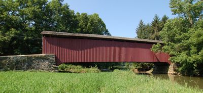
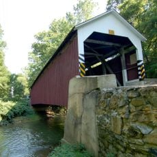
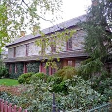
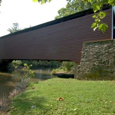
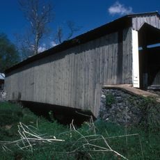
Forry's Mill Covered Bridge, Covered bridge in Lancaster County, United States.

Description

Forry's Mill Covered Bridge is a wooden structure that spans Chiques Creek and showcases traditional Pennsylvania bridge-building methods. Its red exterior with white approach ramps makes it recognizable, and the bridge features double Burr arch trusses as its primary structural system.

History

The bridge was built in 1869 by Elias McMellen to connect West Hempfield and Rapho Townships. Major restoration work in the 1980s preserved the structure and ensured its continued functionality.

Culture

The structure represents traditional Pennsylvania bridge construction methods, connecting West Hempfield and Rapho Townships while maintaining its original architectural elements.

Practical

The bridge is accessed via Bridge Valley Road located north of Pennsylvania Route 23. Visitors should note that this crossing remains an active route connecting the two townships.

Did you know?

This crossing marks the final covered bridge over Chiques Creek before the water reaches the Susquehanna River. This position makes it the last historical passage of its kind along the entire creek system.

Location
GPS coordinates
40.06646,-76.47810
Latest update
December 14, 2025 18:15

AroundUs brings together thousands of curated places, local tips, and hidden gems, enriched daily by 60,000 contributors worldwide. Discover all places nearby (West Hempfield Township).

Around this place
Columbia–Wrightsville Bridge
United States of America

Columbia–Wrightsville Bridge

5.3 km
United States of America

Chickies Ridge

4.3 km
Samuel S. Lewis State Park
United States of America

Samuel S. Lewis State Park

9.9 km
Cameron Estate
United States of America

Cameron Estate

8.7 km
Wright's Ferry Bridge
United States of America

Wright's Ferry Bridge

5.1 km
Siegrist's Mill Covered Bridge
United States of America

Siegrist's Mill Covered Bridge

1.2 km
Donegal Presbyterian Church Complex
United States of America

Donegal Presbyterian Church Complex

8.5 km
Donegal Mills Plantation
United States of America

Donegal Mills Plantation

5.7 km
Wright's Ferry Mansion
United States of America

Wright's Ferry Mansion

4.6 km
Schenck's Mill Covered Bridge
United States of America

Schenck's Mill Covered Bridge

7.1 km
Columbia Historic District
United States of America

Columbia Historic District

4.2 km
Marietta Historic District (Marietta, Pennsylvania)
United States of America

Marietta Historic District (Marietta, Pennsylvania)

6.9 km
Byers-Muma House
United States of America

Byers-Muma House

6.6 km
Chickies Historic District
United States of America

Chickies Historic District

6.9 km
Grove Mansion
United States of America

Grove Mansion

8.7 km
Risser's Mill Covered Bridge
United States of America

Risser's Mill Covered Bridge

8.4 km
United States of America

Nissly Swiss Chocolate Company

6.7 km
Byrd Leibhart Site
United States of America

Byrd Leibhart Site

10 km
Linden House
United States of America

Linden House

5.5 km
Strickler Site
United States of America

Strickler Site

9.7 km
Bachman and Forry Tobacco Warehouse
United States of America

Bachman and Forry Tobacco Warehouse

4.7 km
Frey-Haverstick Site
United States of America

Frey-Haverstick Site

8 km
George Brown's Sons Cotton and Woolen Mill
United States of America

George Brown's Sons Cotton and Woolen Mill

5 km
Murry Site
United States of America

Murry Site

10 km
Manor Street Elementary School
United States of America

Manor Street Elementary School

4.4 km
Wrightsville Historic District
United States of America

Wrightsville Historic District

6.4 km
Christian Habeck Farm
United States of America

Christian Habeck Farm

9.7 km
National Watch and Clock Museum
United States of America

National Watch and Clock Museum

3.9 km
Show the full map
« Forry's Mill Covered Bridge - Covered bridge in Lancaster County, United States » is provided by Around Us (aroundus.com). Images and texts are derived from Wikimedia project under a Creative Commons license. You are allowed to copy, distribute, and modify copies of this page, under the conditions set by the license, as long as this note is clearly visible.

Discover hidden gems everywhere you go!

From secret cafés to breathtaking viewpoints, skip the crowded tourist spots and find places that match your style. Our app makes it easy with voice search, smart filtering, route optimization, and insider tips from travelers worldwide. Download now for the complete mobile experience.

Around Us App Screenshot

A unique approach to discovering new places

Le Figaro

All the places worth exploring

France Info

A tailor-made excursion in just a few clicks

20 Minutes

Around Us
Travel Guide & Maps
Download

Send to your phone

QR Code
1

Open the camera app on your mobile.

2

Point at the QR code with your camera. A notification will appear.

3

Tap the notification to open the link.