Siegrist's Mill Covered Bridge

Log in to your account

AroundUs is a community-driven map of interesting places, built by curious explorers like you. It grows with every review, story, and photo you share.
Connect to save your favorite spots, contribute locations, and create personalized routes.
Continue with Google
Continue with Apple
Continue with X
Continue with Facebook
Continue with email
By continuing, you accept our Terms and Conditions and our Privacy Policy
Create an account
Add to collection
Map
Suggest a change
Share

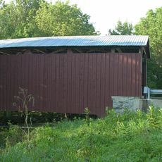
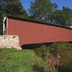
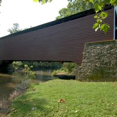
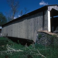
Siegrist's Mill Covered Bridge, Historical covered bridge in Lancaster County, United States.

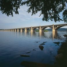
Siegrist's Mill Covered Bridge spans about 88 feet over Chiques Creek, connecting Rapho and West Hempfield townships with wooden double Burr arch truss construction. The structure features a deck width of roughly 12 feet and overhead clearance of about 11.5 feet for vehicle passage.

James C. Carpenter built this bridge in 1885 for the Lancaster County Board of Commissioners as part of the region's infrastructure expansion. The structure survived for over a century but required major restoration after severe damage in 2011, reopening with reinforced elements three years later.

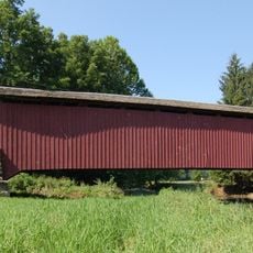
Religious passages painted on wooden boards beneath the bridge deck show how faith was woven into the everyday infrastructure of Lancaster County communities. These painted messages remain visible to travelers crossing the creek, creating a personal connection between the structure and those who use it.

The bridge accommodates vehicle traffic but has limited width and clearance, so larger vehicles need to proceed carefully. Visitors should move slowly to protect the historic structure and to safely experience the crossing over the creek.

Tropical Storm Lee caused major damage to the bridge in 2011, but restoration efforts brought it back to service with new structural reinforcements. This recovery demonstrates how historic wooden bridges can be preserved using modern engineering techniques while maintaining their original character.

Location: Rapho Township

Location: West Hempfield Township

GPS coordinates: 40.07600,-76.47100

Latest update: December 14, 2025 13:05

Photos
Around this place
Columbia–Wrightsville Bridge
United States of America

Columbia–Wrightsville Bridge

6.5 km
United States of America

Chickies Ridge

5.4 km
Cameron Estate
United States of America

Cameron Estate

8.8 km
Wright's Ferry Bridge
United States of America

Wright's Ferry Bridge

6.3 km
Landis Mill Covered Bridge
United States of America

Landis Mill Covered Bridge

10.8 km
Donegal Presbyterian Church Complex
United States of America

Donegal Presbyterian Church Complex

8.6 km
Donegal Mills Plantation
United States of America

Donegal Mills Plantation

6 km
Wright's Ferry Mansion
United States of America

Wright's Ferry Mansion

5.9 km
Kauffman's Distillery Covered Bridge
United States of America

Kauffman's Distillery Covered Bridge

9.6 km
Forry's Mill Covered Bridge
United States of America

Forry's Mill Covered Bridge

1.2 km
Schenck's Mill Covered Bridge
United States of America

Schenck's Mill Covered Bridge

5.9 km
Columbia Historic District
United States of America

Columbia Historic District

5.4 km
Marietta Historic District (Marietta, Pennsylvania)
United States of America

Marietta Historic District (Marietta, Pennsylvania)

7.7 km
Byers-Muma House
United States of America

Byers-Muma House

6.9 km
Chickies Historic District
United States of America

Chickies Historic District

7.7 km
Grove Mansion
United States of America

Grove Mansion

9.3 km
Risser's Mill Covered Bridge
United States of America

Risser's Mill Covered Bridge

7.6 km
United States of America

Nissly Swiss Chocolate Company

6.3 km
Linden House
United States of America

Linden House

6.3 km
Strickler Site
United States of America

Strickler Site

10.7 km
Bachman and Forry Tobacco Warehouse
United States of America

Bachman and Forry Tobacco Warehouse

5.9 km
Frey-Haverstick Site
United States of America

Frey-Haverstick Site

9 km
George Brown's Sons Cotton and Woolen Mill
United States of America

George Brown's Sons Cotton and Woolen Mill

4.3 km
Murry Site
United States of America

Murry Site

10.9 km
Manor Street Elementary School
United States of America

Manor Street Elementary School

5.6 km
Wrightsville Historic District
United States of America

Wrightsville Historic District

7.6 km
Christian Habeck Farm
United States of America

Christian Habeck Farm

9.2 km
National Watch and Clock Museum
United States of America

National Watch and Clock Museum

5.1 km
Show the full map
Reviews

Visited this place? Tap the stars to rate it and share your experience / photos with the community! Try now! You can cancel it anytime.

« Siegrist's Mill Covered Bridge - Historical covered bridge in Lancaster County, United States » is provided by Around Us (aroundus.com). Images and texts are derived from Wikimedia project under a Creative Commons license. You are allowed to copy, distribute, and modify copies of this page, under the conditions set by the license, as long as this note is clearly visible.

Discover hidden gems everywhere you go!

From secret cafés to breathtaking viewpoints, skip the crowded tourist spots and find places that match your style. Our app makes it easy with voice search, smart filtering, route optimization, and insider tips from travelers worldwide. Download now for the complete mobile experience.

Around Us App Screenshot

A unique approach to discovering new places

Le Figaro

All the places worth exploring

France Info

A tailor-made excursion in just a few clicks

20 Minutes