Enable Location

We need your location to show you interesting places around you

Discover nearby places

Find interesting locations and hidden gems around you

Precise directions

Get accurate directions and distances to places

Your location is never shared with other users. It's only used when you tap the location button.

Donegal Presbyterian Church Complex

Log in to your account

Join the adventure

Create your free account and start exploring (like 60k+ others)

We will send you a code to connect

or
Continue with Google
Continue with Apple
By continuing, you accept our Terms and Conditions and our Privacy Policy

Check your inbox

We've sent a pincode in your inbox. Please enter the code below.

Donegal Presbyterian Church Complex

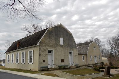
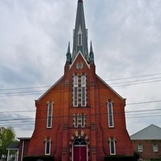
Donegal Presbyterian Church Complex, Presbyterian church complex in East Donegal Township, Pennsylvania, US.

Description

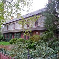
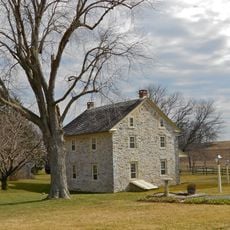
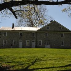
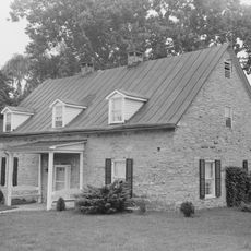
Donegal Presbyterian Church Complex is a stone church building in East Donegal Township with a gambrel roof and traditional architectural layout set on 7.5 acres of grounds. The property includes the William Kerr Study House and an educational wing built in 1958 for religious instruction and community use.

History

The church was built in 1732 and represents one of the region's oldest Presbyterian establishments. It received National Register of Historic Places listing in 1985, recognizing more than 250 years of continuous religious use and community presence.

Culture

The cemetery with its stone wall holds graves of pioneering families and local leaders who shaped the region's religious character. Walking through it, you sense the deep connection between this congregation and centuries of faith in the community.

Practical

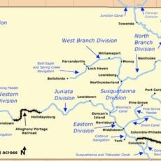
The site is accessible for walking through the grounds and cemetery, which spread across the 7.5-acre property. Visitors should wear comfortable shoes since exploring the main church building, ancillary structures, and burial grounds requires moving between different areas on foot.

Did you know?

A memorial marker marks where the original Witness Tree once stood, beneath which congregation members swore an oath to the American cause in 1777. This tree witnessed an important moment in local history that showed the connection between faith and nation.

Location
GPS coordinates
40.10111,-76.56667
Latest update
December 14, 2025 14:41

AroundUs brings together thousands of curated places, local tips, and hidden gems, enriched daily by 60,000 contributors worldwide. Discover all places nearby (Pennsylvania).

Around this place
Columbia–Wrightsville Bridge
United States of America

Columbia–Wrightsville Bridge

9.1 km
United States of America

Chickies Ridge

6.6 km
Samuel S. Lewis State Park
United States of America

Samuel S. Lewis State Park

11.8 km
Cameron Estate
United States of America

Cameron Estate

239 m
Wright's Ferry Bridge
United States of America

Wright's Ferry Bridge

8.1 km
United States of America

Shocks Mills Bridge

7.4 km
Siegrist's Mill Covered Bridge
United States of America

Siegrist's Mill Covered Bridge

8.6 km
Donegal Mills Plantation
United States of America

Donegal Mills Plantation

2.9 km
Codorus Forge and Furnace Historic District
United States of America

Codorus Forge and Furnace Historic District

9.5 km
Wright's Ferry Mansion
United States of America

Wright's Ferry Mansion

9.6 km
Forry's Mill Covered Bridge
United States of America

Forry's Mill Covered Bridge

8.5 km
Schenck's Mill Covered Bridge
United States of America

Schenck's Mill Covered Bridge

12.1 km
Columbia Historic District
United States of America

Columbia Historic District

9.2 km
Marietta Historic District (Marietta, Pennsylvania)
United States of America

Marietta Historic District (Marietta, Pennsylvania)

5.1 km
Byers-Muma House
United States of America

Byers-Muma House

2.1 km
Chickies Historic District
United States of America

Chickies Historic District

4.9 km
Grove Mansion
United States of America

Grove Mansion

3.4 km
Risser's Mill Covered Bridge
United States of America

Risser's Mill Covered Bridge

6.8 km
Codorus Navigation
United States of America

Codorus Navigation

8.1 km
Locust Grove
United States of America

Locust Grove

8.4 km
United States of America

Nissly Swiss Chocolate Company

3.6 km
Martin Schultz House
United States of America

Martin Schultz House

11.8 km
Linden House
United States of America

Linden House

5.1 km
Bachman and Forry Tobacco Warehouse
United States of America

Bachman and Forry Tobacco Warehouse

9.6 km
George Brown's Sons Cotton and Woolen Mill
United States of America

George Brown's Sons Cotton and Woolen Mill

6 km
Manor Street Elementary School
United States of America

Manor Street Elementary School

10.5 km
Wrightsville Historic District
United States of America

Wrightsville Historic District

9.2 km
National Watch and Clock Museum
United States of America

National Watch and Clock Museum

9 km
Show the full map
« Donegal Presbyterian Church Complex - Presbyterian church complex in East Donegal Township, Pennsylvania, US » is provided by Around Us (aroundus.com). Images and texts are derived from Wikimedia project under a Creative Commons license. You are allowed to copy, distribute, and modify copies of this page, under the conditions set by the license, as long as this note is clearly visible.

Discover hidden gems everywhere you go!

From secret cafés to breathtaking viewpoints, skip the crowded tourist spots and find places that match your style. Our app makes it easy with voice search, smart filtering, route optimization, and insider tips from travelers worldwide. Download now for the complete mobile experience.

Around Us App Screenshot

A unique approach to discovering new places

Le Figaro

All the places worth exploring

France Info

A tailor-made excursion in just a few clicks

20 Minutes

Around Us
Travel Guide & Maps
Download

Send to your phone

QR Code
1

Open the camera app on your mobile.

2

Point at the QR code with your camera. A notification will appear.

3

Tap the notification to open the link.