Enable Location

We need your location to show you interesting places around you

Discover nearby places

Find interesting locations and hidden gems around you

Precise directions

Get accurate directions and distances to places

Your location is never shared with other users. It's only used when you tap the location button.

Log in to your account

Join the adventure

Create your free account and start exploring (like 60k+ others)

We will send you a code to connect

or
Continue with Google
Continue with Apple
By continuing, you accept our Terms and Conditions and our Privacy Policy

Check your inbox

We've sent a pincode in your inbox. Please enter the code below.

Shocks Mills Bridge

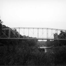
Shocks Mills Bridge, Railway bridge over Susquehanna River, Pennsylvania, United States

Description

Shocks Mills Bridge is a railway bridge crossing the Susquehanna River in Pennsylvania using stone arches to carry tracks across the water. The structure combines original masonry with modern reinforcements of concrete and steel that were added during later reconstruction work.

History

The Pennsylvania Railroad built this bridge in 1905 to connect Philadelphia with Harrisburg for freight transport. A major storm later damaged several supporting piers, triggering extensive reconstruction work decades afterward.

Culture

The bridge shows how people built railway lines to move freight across rivers using skilled masonry work. Its stone arches remain visible from the riverbank where locals and visitors can see the craftsmanship up close.

Practical

The bridge is currently in active use for freight train operations and is visible from the nearby riverbank. Visitors can view and photograph the structure from designated public access points in the area.

Did you know?

The bridge displays a rare feature where original stone arches stand alongside modern steel sections, creating a visible contrast between old and new engineering methods. This blend of two different eras of bridge construction is uncommon to see in such a clear way.

Location
Official opening
January 1, 1905
GPS coordinates
40.06160,-76.63710
Latest update
December 14, 2025 09:45

AroundUs brings together thousands of curated places, local tips, and hidden gems, enriched daily by 60,000 contributors worldwide. Discover all places nearby (Pennsylvania).

Around this place
Haines Shoe House
United States of America

Haines Shoe House

7 km
Columbia–Wrightsville Bridge
United States of America

Columbia–Wrightsville Bridge

10.9 km
United States of America

Chickies Ridge

9.6 km
Samuel S. Lewis State Park
United States of America

Samuel S. Lewis State Park

10.4 km
Cameron Estate
United States of America

Cameron Estate

7.4 km
Wright's Ferry Bridge
United States of America

Wright's Ferry Bridge

10.1 km
Donegal Presbyterian Church Complex
United States of America

Donegal Presbyterian Church Complex

7.4 km
Donegal Mills Plantation
United States of America

Donegal Mills Plantation

8.6 km
Emig Mansion
United States of America

Emig Mansion

8.2 km
Codorus Forge and Furnace Historic District
United States of America

Codorus Forge and Furnace Historic District

2.1 km
Ashley and Bailey Silk Mill
United States of America

Ashley and Bailey Silk Mill

7.6 km
Sinking Springs Farms
United States of America

Sinking Springs Farms

10.6 km
Marietta Historic District (Marietta, Pennsylvania)
United States of America

Marietta Historic District (Marietta, Pennsylvania)

6.8 km
Byers-Muma House
United States of America

Byers-Muma House

7.8 km
Chickies Historic District
United States of America

Chickies Historic District

6.8 km
Grove Mansion
United States of America

Grove Mansion

5 km
Pleasureville Historic District
United States of America

Pleasureville Historic District

8.7 km
Strickler Family Farmhouse
United States of America

Strickler Family Farmhouse

8.4 km
East York Historic District
United States of America

East York Historic District

10.7 km
Codorus Navigation
United States of America

Codorus Navigation

708 m
Locust Grove
United States of America

Locust Grove

2.8 km
Martin Schultz House
United States of America

Martin Schultz House

7.2 km
Linden House
United States of America

Linden House

8.1 km
Michael and Magdealena Bixler Farmstead
United States of America

Michael and Magdealena Bixler Farmstead

7.3 km
Bridge between East Manchester and Newberry Townships
United States of America

Bridge between East Manchester and Newberry Townships

7.2 km
Wrightsville Historic District
United States of America

Wrightsville Historic District

10.2 km
William Shelly School and Annex
United States of America

William Shelly School and Annex

10.9 km
Joseph Bucher House
United States of America

Joseph Bucher House

7.1 km
Show the full map
« Shocks Mills Bridge - Railway bridge over Susquehanna River, Pennsylvania, United States » is provided by Around Us (aroundus.com). Images and texts are derived from Wikimedia project under a Creative Commons license. You are allowed to copy, distribute, and modify copies of this page, under the conditions set by the license, as long as this note is clearly visible.

Discover hidden gems everywhere you go!

From secret cafés to breathtaking viewpoints, skip the crowded tourist spots and find places that match your style. Our app makes it easy with voice search, smart filtering, route optimization, and insider tips from travelers worldwide. Download now for the complete mobile experience.

Around Us App Screenshot

A unique approach to discovering new places

Le Figaro

All the places worth exploring

France Info

A tailor-made excursion in just a few clicks

20 Minutes

Around Us
Travel Guide & Maps
Download

Send to your phone

QR Code
1

Open the camera app on your mobile.

2

Point at the QR code with your camera. A notification will appear.

3

Tap the notification to open the link.