Samuel S. Lewis State Park

Log in to your account

AroundUs is a community-driven map of interesting places, built by curious explorers like you. It grows with every review, story, and photo you share.
Connect to save your favorite spots, contribute locations, and create personalized routes.
Continue with Google
Continue with Apple
Continue with X
Continue with Facebook
Continue with email
By continuing, you accept our Terms and Conditions and our Privacy Policy
Create an account
Add to collection
Map
Suggest a change
Share

Samuel S. Lewis State Park, State park in Lower Windsor Township, United States

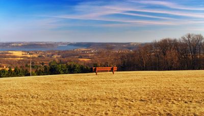
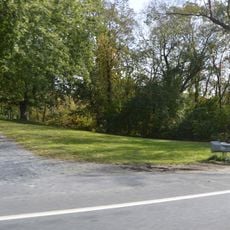
Samuel S. Lewis State Park is an 85-acre natural area on Mount Pisgah in Lower Windsor Township, featuring pine forests, hiking trails, and open meadows at roughly 885 feet elevation. The grounds include picnic areas, three reservable pavilions, and a one-mile trail winding through the wooded sections.

The park was established in 1954 when Samuel S. Lewis donated 35 acres of farmland to Pennsylvania, creating the original core. Subsequent land acquisitions over the following decades gradually expanded the property until it reached its current size by 1999.

Local astronomy groups regularly gather at Mount Pisgah's summit to observe the night sky and share knowledge about celestial objects and constellations. The open, elevated location with minimal light pollution makes it an ideal spot for these community stargazing gatherings.

The park opens daily from sunrise to sunset and offers good access with parking areas and trails suitable for various fitness levels. Visitors should bring weather-appropriate clothing, as the ridge location tends to be windy, particularly at the summit.

The steady winds at Mount Pisgah's ridge make this location a primary destination for kite enthusiasts throughout the region. The open, elevated setting provides ideal conditions for this activity, attracting regular practitioners who take advantage of the natural air currents.

Location: Pennsylvania

Inception: 1954

Website: https://dcnr.pa.gov/StateParks/FindAPark/SamuelSLewisStatePark

GPS coordinates: 39.99640,-76.54920

Latest update: December 12, 2025 09:08

Photos
Around this place
Haines Shoe House
United States of America

Haines Shoe House

7.5 km
Columbia–Wrightsville Bridge
United States of America

Columbia–Wrightsville Bridge

4.6 km
United States of America

Chickies Ridge

6.4 km
Wright's Ferry Bridge
United States of America

Wright's Ferry Bridge

4.9 km
United States of America

Shocks Mills Bridge

10.4 km
Donegal Mills Plantation
United States of America

Donegal Mills Plantation

9.9 km
Wright's Ferry Mansion
United States of America

Wright's Ferry Mansion

5.4 km
Forry's Mill Covered Bridge
United States of America

Forry's Mill Covered Bridge

9.9 km
Columbia Historic District
United States of America

Columbia Historic District

5.7 km
Dritt Mansion
United States of America

Dritt Mansion

4.9 km
Marietta Historic District (Marietta, Pennsylvania)
United States of America

Marietta Historic District (Marietta, Pennsylvania)

6.7 km
Byers-Muma House
United States of America

Byers-Muma House

10.1 km
Chickies Historic District
United States of America

Chickies Historic District

6.8 km
Grove Mansion
United States of America

Grove Mansion

8.9 km
Strickler Family Farmhouse
United States of America

Strickler Family Farmhouse

9.4 km
Martin Schultz House
United States of America

Martin Schultz House

5.1 km
Byrd Leibhart Site
United States of America

Byrd Leibhart Site

4.8 km
Linden House
United States of America

Linden House

7.1 km
Strickler Site
United States of America

Strickler Site

7.7 km
Bachman and Forry Tobacco Warehouse
United States of America

Bachman and Forry Tobacco Warehouse

5.3 km
Burgholtshouse
United States of America

Burgholtshouse

4.5 km
Frey-Haverstick Site
United States of America

Frey-Haverstick Site

6.7 km
Chestnut Hill
United States of America

Chestnut Hill

8.6 km
Murry Site
United States of America

Murry Site

8.4 km
Manor Street Elementary School
United States of America

Manor Street Elementary School

6.1 km
Shultz-Funk Site
United States of America

Shultz-Funk Site

8.6 km
Wrightsville Historic District
United States of America

Wrightsville Historic District

3.6 km
National Watch and Clock Museum
United States of America

National Watch and Clock Museum

6.1 km
Show the full map
Reviews

Visited this place? Tap the stars to rate it and share your experience / photos with the community! Try now! You can cancel it anytime.

« Samuel S. Lewis State Park - State park in Lower Windsor Township, United States » is provided by Around Us (aroundus.com). Images and texts are derived from Wikimedia project under a Creative Commons license. You are allowed to copy, distribute, and modify copies of this page, under the conditions set by the license, as long as this note is clearly visible.

Discover hidden gems everywhere you go!

From secret cafés to breathtaking viewpoints, skip the crowded tourist spots and find places that match your style. Our app makes it easy with voice search, smart filtering, route optimization, and insider tips from travelers worldwide. Download now for the complete mobile experience.

Around Us App Screenshot

A unique approach to discovering new places

Le Figaro

All the places worth exploring

France Info

A tailor-made excursion in just a few clicks

20 Minutes