Enable Location

We need your location to show you interesting places around you

Discover nearby places

Find interesting locations and hidden gems around you

Precise directions

Get accurate directions and distances to places

Your location is never shared with other users. It's only used when you tap the location button.

Wright's Ferry Bridge

Log in to your account

Start exploring — it's free

Trusted by 61,585 travelers worldwide

Continue with Google
Continue with Apple
or

We will send you a code to connect

By continuing, you accept our Terms and Conditions and our Privacy Policy

Check your inbox

We've sent a pincode in your inbox. Please enter the code below.

Wright's Ferry Bridge

Wright's Ferry Bridge, River bridge in Columbia, Pennsylvania.

Description

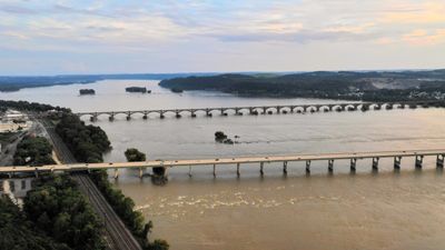
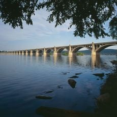
Wright's Ferry Bridge is a road bridge spanning the Susquehanna River and connecting Columbia and Wrightsville, composed of forty-six sections supported by forty-five concrete and steel piers. It carries four lanes of divided highway as a key section of US Route 30.

History

The structure was commissioned by Pennsylvania's Commonwealth government during the 1960s to redirect US Route 30 and bypass the river towns. This new route was needed to handle growing traffic more efficiently and relieve congestion in the downtown areas.

Culture

The bridge takes its name from the Wright's Ferry settlement established in 1726, where John Wright ran a ferry service that was vital for moving goods and people across the river. This historical crossing point shaped the region and made it a key hub for regional movement.

Practical

The bridge carries traffic in both directions across four lanes and is part of a major route, so expect regular flow and congestion during peak times. It is wise to drive carefully and be aware of weather conditions when crossing.

Did you know?

Shortly after opening, the structure received an experimental weather-resistant coating on the roadway surface as part of a research project. This early use of protective treatment made it a test case for modern infrastructure solutions.

Location
Inception
November 21, 1972
Official opening
November 21, 1972
GPS coordinates
40.03600,-76.52300
Latest update
December 13, 2025 11:42

AroundUs brings together thousands of curated places, local tips, and hidden gems, enriched daily by 60,000 contributors worldwide. Discover all places nearby (Pennsylvania).

Around this place
Columbia–Wrightsville Bridge
United States of America

Columbia–Wrightsville Bridge

932 m
United States of America

Chickies Ridge

1.7 km
Samuel S. Lewis State Park
United States of America

Samuel S. Lewis State Park

4.9 km
Cameron Estate
United States of America

Cameron Estate

8.4 km
Siegrist's Mill Covered Bridge
United States of America

Siegrist's Mill Covered Bridge

6.3 km
Donegal Presbyterian Church Complex
United States of America

Donegal Presbyterian Church Complex

8.1 km
Donegal Mills Plantation
United States of America

Donegal Mills Plantation

5.7 km
Wright's Ferry Mansion
United States of America

Wright's Ferry Mansion

1.8 km
Forry's Mill Covered Bridge
United States of America

Forry's Mill Covered Bridge

5.1 km
Columbia Historic District
United States of America

Columbia Historic District

1.7 km
Dritt Mansion
United States of America

Dritt Mansion

6.9 km
Marietta Historic District (Marietta, Pennsylvania)
United States of America

Marietta Historic District (Marietta, Pennsylvania)

3.7 km
Byers-Muma House
United States of America

Byers-Muma House

6.1 km
Chickies Historic District
United States of America

Chickies Historic District

3.8 km
Grove Mansion
United States of America

Grove Mansion

6.4 km
United States of America

Nissly Swiss Chocolate Company

8.6 km
Martin Schultz House
United States of America

Martin Schultz House

8.3 km
Byrd Leibhart Site
United States of America

Byrd Leibhart Site

6.8 km
Linden House
United States of America

Linden House

3.1 km
Strickler Site
United States of America

Strickler Site

8.2 km
Bachman and Forry Tobacco Warehouse
United States of America

Bachman and Forry Tobacco Warehouse

1.8 km
Burgholtshouse
United States of America

Burgholtshouse

7.8 km
Frey-Haverstick Site
United States of America

Frey-Haverstick Site

6.4 km
George Brown's Sons Cotton and Woolen Mill
United States of America

George Brown's Sons Cotton and Woolen Mill

8.4 km
Murry Site
United States of America

Murry Site

8.7 km
Manor Street Elementary School
United States of America

Manor Street Elementary School

3 km
Wrightsville Historic District
United States of America

Wrightsville Historic District

1.4 km
National Watch and Clock Museum
United States of America

National Watch and Clock Museum

1.8 km
Show the full map
« Wright's Ferry Bridge - River bridge in Columbia, Pennsylvania » is provided by Around Us (aroundus.com). Images and texts are derived from Wikimedia project under a Creative Commons license. You are allowed to copy, distribute, and modify copies of this page, under the conditions set by the license, as long as this note is clearly visible.

Discover hidden gems everywhere you go!

From secret cafés to breathtaking viewpoints, skip the crowded tourist spots and find places that match your style. Our app makes it easy with voice search, smart filtering, route optimization, and insider tips from travelers worldwide. Download now for the complete mobile experience.

Around Us App Screenshot

A unique approach to discovering new places

Le Figaro

All the places worth exploring

France Info

A tailor-made excursion in just a few clicks

20 Minutes

Around Us
Travel Guide & Maps
Download

Send to your phone

QR Code
1

Open the camera app on your mobile.

2

Point at the QR code with your camera. A notification will appear.

3

Tap the notification to open the link.