Enable Location

We need your location to show you interesting places around you

Discover nearby places

Find interesting locations and hidden gems around you

Precise directions

Get accurate directions and distances to places

Your location is never shared with other users. It's only used when you tap the location button.

Battery 223

Log in to your account

Start exploring — it's free

Trusted by 62,304 travelers worldwide

Continue with Google
Continue with Apple
or

We will send you a code to connect

By continuing, you accept our Terms and Conditions and our Privacy Policy

Check your inbox

We've sent a pincode in your inbox. Please enter the code below.

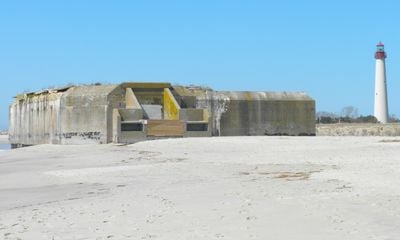
Battery 223, World War II artillery battery at Cape May Point State Park, United States.

Battery 223 is a reinforced concrete military fortification located at Cape May Point State Park that once defended the coast. The bunker contains multiple interior spaces for operations, storage, and troop quarters built within walls several feet thick.

The facility was built in 1943 as part of the Fort Miles defense network that protected this coastline during World War II. It represents the military construction efforts made to secure American beaches against potential attacks.

The structure shows how people built defenses to protect the coast during wartime and what military engineering looked like in the 1940s. You can still see where soldiers worked and stored supplies inside.

The fortification sits within Cape May Point State Park and is partially exposed by coastal erosion, which can affect how accessible it is. Weather conditions matter when visiting since rain and moisture can influence how safely you can walk around the site.

The bunker includes a sophisticated airlock system at its entrances designed to protect soldiers from chemical weapons exposure. This safety feature was unusual for the time and shows the military's concerns about emerging threats.

The community of curious travelers

AroundUs brings together thousands of curated places, local tips, and hidden gems, enriched daily by 60,000 contributors worldwide.

Start exploring
Location
GPS coordinates
38.93149,-74.95553
Latest update
December 9, 2025 18:45
Around this place
Cape May Historic District
United States of America

Cape May Historic District

3.8 km
Congress Hall
United States of America

Congress Hall

2.7 km
Cape May Lighthouse
United States of America

Cape May Lighthouse

455 m
Emlen Physick Estate
United States of America

Emlen Physick Estate

3.7 km
Sunset Beach
United States of America

Sunset Beach

1.9 km
The Great White
United States of America

The Great White

14 km
Sunset Beach
United States of America

Sunset Beach

1.9 km
Harriet Tubman Museum
United States of America

Harriet Tubman Museum

3 km
Cape May Point State Park
United States of America

Cape May Point State Park

502 m
Naval Air Station Wildwood Aviation Museum
United States of America

Naval Air Station Wildwood Aviation Museum

9.1 km
United States of America

Poverty Beach

6.4 km
United States of America

Higbee Beach Wildlife Management Area

3.4 km
Fire Control Tower No. 23
United States of America

Fire Control Tower No. 23

1.7 km
United States of America

Cape May Winery & Vineyard

5.4 km
United States of America

Turtle Gut Inlet

9.4 km
Historic Cold Spring Village
United States of America

Historic Cold Spring Village

6.3 km
United States of America

Cape May Stage

2.8 km
Jonathan Pyne House
United States of America

Jonathan Pyne House

840 m
John B. McCreary House
United States of America

John B. McCreary House

3.1 km
Fishing Creek Schoolhouse
United States of America

Fishing Creek Schoolhouse

9.3 km
Marine National Bank
United States of America

Marine National Bank

13.9 km
Owen Coachman House
United States of America

Owen Coachman House

4.1 km
Whilldin-Miller House
United States of America

Whilldin-Miller House

2.1 km
Cold Spring Grange Hall
United States of America

Cold Spring Grange Hall

6.3 km
George Hildreth House
United States of America

George Hildreth House

6.4 km
TBM-3E Avenger Torpedo Bomber
United States of America

TBM-3E Avenger Torpedo Bomber

9.1 km
Octagonal Poultry House
United States of America

Octagonal Poultry House

6.5 km
Middle Thorofare Bridge
United States of America

Middle Thorofare Bridge

7.6 km
Show the full map
« Battery 223 - World War II artillery battery at Cape May Point State Park, United States » is provided by Around Us (aroundus.com). Images and texts are derived from Wikimedia project under a Creative Commons license. You are allowed to copy, distribute, and modify copies of this page, under the conditions set by the license, as long as this note is clearly visible.

Discover hidden gems everywhere you go!

From secret cafés to breathtaking viewpoints, skip the crowded tourist spots and find places that match your style. Our app makes it easy with voice search, smart filtering, route optimization, and insider tips from travelers worldwide. Download now for the complete mobile experience.

Around Us App Screenshot

A unique approach to discovering new places

Le Figaro

All the places worth exploring

France Info

A tailor-made excursion in just a few clicks

20 Minutes

Around Us
Travel Guide & Maps
Download

Send to your phone

QR Code
1

Open the camera app on your mobile.

2

Point at the QR code with your camera. A notification will appear.

3

Tap the notification to open the link.