Chest opened
+${chestReward.xp} XP
Explorer
NOUVEAU ×${chestReward.collectible.quantity}
tapez pour fermer
Chest locked

Open chests in the app

Around Us is built for your phone — chests unlock when you walk, explore and capture nearby places.

Enable Location

We need your location to show you interesting places around you

Discover nearby places

Find interesting locations and hidden gems around you

Precise directions

Get accurate directions and distances to places

Your location is never shared with other users. It's only used when you tap the location button.

Breezewood

Log in to your account

Start exploring — it's free

Trusted by 72,888 travelers worldwide

Continue with Google
Continue with Apple
or

We will send you a code to connect

By continuing, you accept our Terms and Conditions and our Privacy Policy

Check your inbox

We've sent a pincode in your inbox. Please enter the code below.

Discussion Reviews 1 Photos
43.5k Popularity

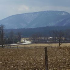
Breezewood, Transportation hub in Bedford County, United States.

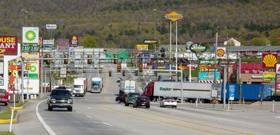
Breezewood functions as a major highway junction where Interstate 70 transitions into local roads before connecting to the Pennsylvania Turnpike. The area consists of a collection of motels, restaurants, and gas stations that line the main thoroughfare.

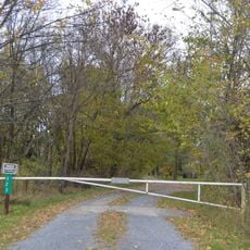
This location emerged in a valley that served as a rest point for automobile travelers on the Lincoln Highway beginning in 1913. Its early role as a stopping place shaped its later function within the interstate highway network.

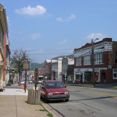
The roadside through this place displays chain restaurants, motels, and gas stations that reflect American highway commerce. These businesses shape how travelers experience and use the location during their journeys.

Over five million vehicles yearly pass through this junction, with services available around the clock for both passenger cars and commercial trucks. Travelers should expect congestion during peak hours and plan accordingly for parking and dining options.

This area represents one of the few gaps in the Interstate Highway System where federal interstate traffic must use local surface streets. This exception makes it a geographic oddity within the otherwise highly standardized highway network of the country.

The community of curious travelers

AroundUs brings together thousands of curated places, local tips, and hidden gems, enriched daily by 60,000 contributors worldwide.

Start exploring
Location
GPS coordinates
39.99694,-78.24056
Latest update
December 14, 2025 20:58
Around this place
Rays Hill Tunnel
United States of America

Rays Hill Tunnel

3.9 km
Bedford Village Archeological Site
United States of America

Bedford Village Archeological Site

23.6 km
Big Mountain
United States of America

Big Mountain

26.4 km
Warriors Path State Park
United States of America

Warriors Path State Park

22.2 km
The Coffee Pot
United States of America

The Coffee Pot

23.8 km
Minersville Coke Ovens
United States of America

Minersville Coke Ovens

24.9 km
Espy House
United States of America

Espy House

22.5 km
United States of America

The Narrows

19.9 km
United States of America

State Game Lands Number 49

17.9 km
Woodvale Historic District
United States of America

Woodvale Historic District

20.8 km
Barclay House
United States of America

Barclay House

22.6 km
Fulton House
United States of America

Fulton House

21.9 km
Jacksons Mill Covered Bridge
United States of America

Jacksons Mill Covered Bridge

3.9 km
Halls Mill Covered Bridge
United States of America

Halls Mill Covered Bridge

15.6 km
Bridge in Snake Spring Township
United States of America

Bridge in Snake Spring Township

19.8 km
Bedford Historic District
United States of America

Bedford Historic District

22 km
Feltons Mill Covered Bridge
United States of America

Feltons Mill Covered Bridge

4.9 km
Everett Historic District
United States of America

Everett Historic District

11.3 km
Robertsdale Historic District
United States of America

Robertsdale Historic District

23.5 km
Russell House
United States of America

Russell House

22.6 km
Cold Spring Farm
United States of America

Cold Spring Farm

22.5 km
Pennsylvania Canal Guard Lock and Feeder Dam, Raystown Branch
United States of America

Pennsylvania Canal Guard Lock and Feeder Dam, Raystown Branch

24.9 km
McConnellsburg Historic District
United States of America

McConnellsburg Historic District

20.8 km
Frehn Bridge
United States of America

Frehn Bridge

26.1 km
New Enterprise Public School
United States of America

New Enterprise Public School

24.1 km
Fort Bedford Museum
United States of America

Fort Bedford Museum

22.6 km
McConnell House
United States of America

McConnell House

21.8 km
Juniata Woolen Mill and Newry Manor
United States of America

Juniata Woolen Mill and Newry Manor

16.3 km
Show the full map
Reviews
Share your experience

No review yet

Discussions
Start a discussion...

No discussion yet

« Breezewood - Transportation hub in Bedford County, United States » is provided by Around Us (aroundus.com). Images and texts are derived from Wikimedia project under a Creative Commons license. You are allowed to copy, distribute, and modify copies of this page, under the conditions set by the license, as long as this note is clearly visible.

Discover hidden gems everywhere you go!

From secret cafés to breathtaking viewpoints, skip the crowded tourist spots and find places that match your style. Our app makes it easy with voice search, smart filtering, route optimization, and insider tips from travelers worldwide. Download now for the complete mobile experience.

Around Us App Screenshot

A unique approach to discovering new places

Le Figaro

All the places worth exploring

France Info

A tailor-made excursion in just a few clicks

20 Minutes

Around Us
Travel Guide & Maps
Download

Send to your phone

QR Code
1

Open the camera app on your mobile.

2

Point at the QR code with your camera. A notification will appear.

3

Tap the notification to open the link.