Rays Hill Tunnel

Log in to your account

AroundUs is a community-driven map of interesting places, built by curious explorers like you. It grows with every review, story, and photo you share.
Connect to save your favorite spots, contribute locations, and create personalized routes.
Continue with Google
Continue with Apple
Continue with X
Continue with Facebook
Continue with email
By continuing, you accept our Terms and Conditions and our Privacy Policy
Create an account
Add to collection
Map
Suggest a change
Share

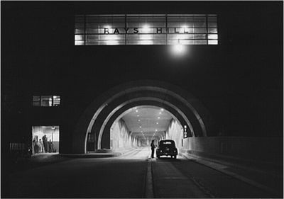
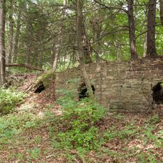
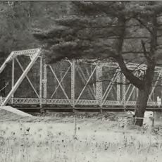
Rays Hill Tunnel, Abandoned tunnel in Bedford County, Pennsylvania, United States.

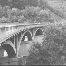
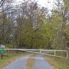
Rays Hill Tunnel is an abandoned tunnel structure in the Appalachian Mountains that extends about 3,500 meters through mountainous terrain between Bedford and Fulton County. The structure features reinforced steel doors and control rooms at both entrances, now sealed from public access.

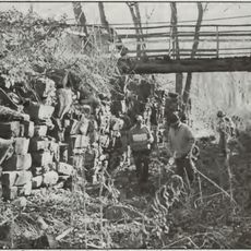
Construction began in 1881 as a railway project, but the tunnel was completed and opened in 1940 as part of the Pennsylvania Turnpike system. It remained in operation until 1968, when it closed and has remained abandoned ever since.

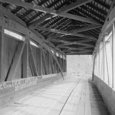
The tunnel displays wall art created by visitors over the years, transforming its interior into an informal gallery space. This creative aspect reflects how explorers have claimed the abandoned structure as a place for self-expression.

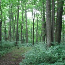
Visitors need powerful flashlights since daylight only penetrates the first stretch of the tunnel, leaving most of the passage in complete darkness. Access is difficult and the tunnel is not prepared for casual visits, so caution is necessary.

Originally planned as an ambitious railway project in 1881, the tunnel remained incomplete for about 60 years before finally being finished. During its years as an active transportation route, it served travelers between two counties until route changes made it obsolete.

Location: Pennsylvania

Official opening: October 1, 1940

GPS coordinates: 40.01810,-78.20390

Latest update: December 8, 2025 13:41

Photos
Around this place
Cowans Gap State Park
United States of America

Cowans Gap State Park

23.9 km
Bedford Village Archeological Site
United States of America

Bedford Village Archeological Site

26.3 km
Big Mountain
United States of America

Big Mountain

24 km
Warriors Path State Park
United States of America

Warriors Path State Park

20.3 km
Minersville Coke Ovens
United States of America

Minersville Coke Ovens

22.2 km
Espy House
United States of America

Espy House

25.5 km
United States of America

The Narrows

22.9 km
United States of America

State Game Lands Number 49

21.5 km
Woodvale Historic District
United States of America

Woodvale Historic District

17.5 km
Barclay House
United States of America

Barclay House

25.6 km
Fulton House
United States of America

Fulton House

20 km
Jacksons Mill Covered Bridge
United States of America

Jacksons Mill Covered Bridge

7.8 km
Halls Mill Covered Bridge
United States of America

Halls Mill Covered Bridge

15.3 km
Bridge in Snake Spring Township
United States of America

Bridge in Snake Spring Township

22.9 km
Bedford Historic District
United States of America

Bedford Historic District

25 km
Feltons Mill Covered Bridge
United States of America

Feltons Mill Covered Bridge

8.8 km
Mt. Pleasant Iron Works House
United States of America

Mt. Pleasant Iron Works House

26.6 km
Everett Historic District
United States of America

Everett Historic District

14.3 km
Robertsdale Historic District
United States of America

Robertsdale Historic District

20 km
Russell House
United States of America

Russell House

25.6 km
Cold Spring Farm
United States of America

Cold Spring Farm

20.5 km
Pennsylvania Canal Guard Lock and Feeder Dam, Raystown Branch
United States of America

Pennsylvania Canal Guard Lock and Feeder Dam, Raystown Branch

22.2 km
McConnellsburg Historic District
United States of America

McConnellsburg Historic District

17.5 km
Frehn Bridge
United States of America

Frehn Bridge

22.2 km
New Enterprise Public School
United States of America

New Enterprise Public School

24.3 km
Fort Bedford Museum
United States of America

Fort Bedford Museum

25.6 km
McConnell House
United States of America

McConnell House

19.8 km
Juniata Woolen Mill and Newry Manor
United States of America

Juniata Woolen Mill and Newry Manor

19.3 km
Show the full map
Reviews

Visited this place? Tap the stars to rate it and share your experience / photos with the community! Try now! You can cancel it anytime.

« Rays Hill Tunnel - Abandoned tunnel in Bedford County, Pennsylvania, United States » is provided by Around Us (aroundus.com). Images and texts are derived from Wikimedia project under a Creative Commons license. You are allowed to copy, distribute, and modify copies of this page, under the conditions set by the license, as long as this note is clearly visible.

Discover hidden gems everywhere you go!

From secret cafés to breathtaking viewpoints, skip the crowded tourist spots and find places that match your style. Our app makes it easy with voice search, smart filtering, route optimization, and insider tips from travelers worldwide. Download now for the complete mobile experience.

Around Us App Screenshot

A unique approach to discovering new places

Le Figaro

All the places worth exploring

France Info

A tailor-made excursion in just a few clicks

20 Minutes