Enable Location

We need your location to show you interesting places around you

Discover nearby places

Find interesting locations and hidden gems around you

Precise directions

Get accurate directions and distances to places

Your location is never shared with other users. It's only used when you tap the location button.

Log in to your account

Start exploring — it's free

Trusted by travelers worldwide

Continue with Google
Continue with Apple
or

We will send you a code to connect

By continuing, you accept our Terms and Conditions and our Privacy Policy

Check your inbox

We've sent a pincode in your inbox. Please enter the code below.

Cornplanter State Forest

Cornplanter State Forest, Protected forest area in northwestern Pennsylvania, United States.

Description

Cornplanter State Forest is a protected woodland area spanning Crawford, Forest, and Warren Counties in northwestern Pennsylvania with an extensive network of trails and outdoor opportunities. The forest consists of multiple connected parcels of land that provide wildlife habitat while offering visitors year-round access to natural surroundings.

History

The forest was established following an 1897 Pennsylvania law that authorized land purchases for forest protection after extensive logging by timber companies had devastated the region during the 19th century. This protection effort was part of a broader movement to restore the state's natural resources and end the depletion of forestland.

Culture

The forest takes its name from Chief Cornplanter, a Seneca Nation leader who negotiated between American authorities and the Iroquois Confederacy during the late 1700s and early 1800s. This naming reflects the indigenous presence and history that shaped the region long before it became protected land.

Practical

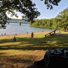
The forest is open year-round with trails suitable for different fitness levels and activities including fishing, hunting, and cross-country skiing in winter months. Visitors should prepare for uneven terrain and bring appropriate gear based on the season, as conditions can change quickly in forested areas.

Did you know?

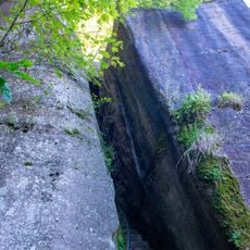
Within the forest lies Anders Run Natural Area, a 96-acre protected zone that contains around 50 acres of original old-growth forest. This section is particularly significant as it shows what the forest looked like before industrial logging changed the landscape.

Location
GPS coordinates
41.87420,-79.15220
Latest update
December 12, 2025 17:48

AroundUs brings together thousands of curated places, local tips, and hidden gems, enriched daily by 60,000 contributors worldwide. Discover all places nearby (Pennsylvania).

Around this place
Kinzua Dam
United States of America

Kinzua Dam

13 km
Allegheny Reservoir
United States of America

Allegheny Reservoir

12.9 km
Allegheny National Recreation Area
United States of America

Allegheny National Recreation Area

25.9 km
Chapman State Park
United States of America

Chapman State Park

13.7 km
Hearts Content Scenic Area
United States of America

Hearts Content Scenic Area

21.9 km
Robert H. Jackson Center
United States of America

Robert H. Jackson Center

25.9 km
United States of America

Tanbark Trail

23 km
United States of America

Hickory Creek Wilderness

25 km
Chapman Lake
United States of America

Chapman Lake

13.5 km
Warren County Courthouse
United States of America

Warren County Courthouse

2.9 km
National Comedy Center Theater
United States of America

National Comedy Center Theater

25.7 km
Busti Mill
United States of America

Busti Mill

20.7 km
Gov. Reuben Fenton Mansion
United States of America

Gov. Reuben Fenton Mansion

25.2 km
United States of America

Lucille Ball Little Theatre

25.7 km
Jamestown Downtown Historic District
United States of America

Jamestown Downtown Historic District

25.8 km
Warren Historic District
United States of America

Warren Historic District

2.8 km
Dr. John Lord House
United States of America

Dr. John Lord House

21.6 km
Struthers Library Building
United States of America

Struthers Library Building

3.1 km
Irvine United Presbyterian Church
United States of America

Irvine United Presbyterian Church

10.6 km
Guy C. Irvine House
United States of America

Guy C. Irvine House

5.1 km
A.J. Hazeltine House
United States of America

A.J. Hazeltine House

3.2 km
Jamestown Armory
United States of America

Jamestown Armory

25.8 km
John P. Jefferson House
United States of America

John P. Jefferson House

3.3 km
Partridge-Sheldon House
United States of America

Partridge-Sheldon House

24.9 km
Woman's Club of Warren
United States of America

Woman's Club of Warren

3 km
Wetmore House
United States of America

Wetmore House

2.9 km
Rimrock Trail
United States of America

Rimrock Trail

17.5 km
Kinzua Beach
United States of America

Kinzua Beach

16.5 km
Show the full map
« Cornplanter State Forest - Protected forest area in northwestern Pennsylvania, United States » is provided by Around Us (aroundus.com). Images and texts are derived from Wikimedia project under a Creative Commons license. You are allowed to copy, distribute, and modify copies of this page, under the conditions set by the license, as long as this note is clearly visible.

Discover hidden gems everywhere you go!

From secret cafés to breathtaking viewpoints, skip the crowded tourist spots and find places that match your style. Our app makes it easy with voice search, smart filtering, route optimization, and insider tips from travelers worldwide. Download now for the complete mobile experience.

Around Us App Screenshot

A unique approach to discovering new places

Le Figaro

All the places worth exploring

France Info

A tailor-made excursion in just a few clicks

20 Minutes

Around Us
Travel Guide & Maps
Download

Send to your phone

QR Code
1

Open the camera app on your mobile.

2

Point at the QR code with your camera. A notification will appear.

3

Tap the notification to open the link.