Enable Location

We need your location to show you interesting places around you

Discover nearby places

Find interesting locations and hidden gems around you

Precise directions

Get accurate directions and distances to places

Your location is never shared with other users. It's only used when you tap the location button.

Log in to your account

Start exploring — it's free

Trusted by 61,511 travelers worldwide

Continue with Google
Continue with Apple
or

We will send you a code to connect

By continuing, you accept our Terms and Conditions and our Privacy Policy

Check your inbox

We've sent a pincode in your inbox. Please enter the code below.

St. Clair National Wildlife Area

St. Clair National Wildlife Area, Nature reserve in Chatham-Kent, Canada

Description

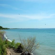
St. Clair National Wildlife Area is a protected reserve of about 355 hectares of wetlands and marshes on the eastern shore of Lake St. Clair in Ontario. The landscape features a mosaic of shallow water, reed beds, and marshy ground that creates different zones for various bird species and other wildlife.

History

The Canadian government established this as a wildlife area in 1978 to protect critical habitats for birds and other species. In 1985 it gained the international Ramsar designation, recognizing its exceptional importance for wetland conservation.

Culture

The site sits along a major migration corridor where millions of birds stop to rest and feed during their journeys across the continent. Visitors can witness large flocks gathering in the reed beds and shallow waters, especially during spring and fall movements.

Practical

Visitors can walk designated trails for wildlife watching, with the Bear Creek unit offering opportunities for boating on Bear Creek and Maxwell Drain. The best time to visit is early morning or late afternoon when birds and other animals are most active.

Did you know?

The site preserves rare remnants of original tall-grass prairie alongside its wetlands, an ecosystem that has largely vanished from the region. This combination creates an unusual habitat where at least 20 endangered species including the eastern foxsnake find shelter.

Location
Inception
1978
GPS coordinates
42.37000,-82.40280
Latest update
December 14, 2025 18:00

AroundUs brings together thousands of curated places, local tips, and hidden gems, enriched daily by 60,000 contributors worldwide. Discover all places nearby (Chatham-Kent).

Around this place
Edsel and Eleanor Ford House
United States of America

Edsel and Eleanor Ford House

39.4 km
Wheatley
Canada

Wheatley

31.1 km
Clinton Valley Center
United States of America

Clinton Valley Center

81.5 km
Grosse Pointe Yacht Club
United States of America

Grosse Pointe Yacht Club

39.2 km
Algonac State Park
United States of America

Algonac State Park

32.1 km
Wheatley Provincial Park
Canada

Wheatley Provincial Park

31.4 km
Buxton National Historic Site and Museum
Canada

Buxton National Historic Site and Museum

16.6 km
Uncle Tom's Cabin Historic Site
Canada

Uncle Tom's Cabin Historic Site

29.3 km
St. Clair Flats Front and Rear Range Light
United States of America

St. Clair Flats Front and Rear Range Light

30.4 km
Tashmoo Park
United States of America

Tashmoo Park

27 km
Carl E. and Alice Candler Schmidt House
United States of America

Carl E. and Alice Candler Schmidt House

40.1 km
Peche Island Rear Range Light
United States of America

Peche Island Rear Range Light

39.2 km
Wallaceburg and District Museum
Canada

Wallaceburg and District Museum

23.9 km
Marine City Water Works
United States of America

Marine City Water Works

39.4 km
Marine City City Hall
United States of America

Marine City City Hall

39.6 km
LeRoy Smith House
United States of America

LeRoy Smith House

31.6 km
Ward–Holland House
United States of America

Ward–Holland House

40 km
Accretion Beach
United States of America

Accretion Beach

39.9 km
Church of the Annunciation
Canada

Church of the Annunciation

14 km
St. Clair Flats Range Front Light
United States of America

St. Clair Flats Range Front Light

30.3 km
Lake St. Clair light
United States of America

Lake St. Clair light

30.8 km
St. Clair Flats Rear Range Light
United States of America

St. Clair Flats Rear Range Light

30.2 km
Crescent Sail Club Beach (Private)
United States of America

Crescent Sail Club Beach (Private)

39.9 km
St. Joseph's Church
Canada

St. Joseph's Church

18.2 km
Edsel and Eleanor Ford House Museum
United States of America

Edsel and Eleanor Ford House Museum

39.9 km
Kolping Park and Chapel
United States of America

Kolping Park and Chapel

37.1 km
John T. Woodhouse House
United States of America

John T. Woodhouse House

40.1 km
Ursuline Motherhouse and the Pines Chapel
Canada

Ursuline Motherhouse and the Pines Chapel

17.6 km
Show the full map
« St. Clair National Wildlife Area - Nature reserve in Chatham-Kent, Canada » is provided by Around Us (aroundus.com). Images and texts are derived from Wikimedia project under a Creative Commons license. You are allowed to copy, distribute, and modify copies of this page, under the conditions set by the license, as long as this note is clearly visible.

Discover hidden gems everywhere you go!

From secret cafés to breathtaking viewpoints, skip the crowded tourist spots and find places that match your style. Our app makes it easy with voice search, smart filtering, route optimization, and insider tips from travelers worldwide. Download now for the complete mobile experience.

Around Us App Screenshot

A unique approach to discovering new places

Le Figaro

All the places worth exploring

France Info

A tailor-made excursion in just a few clicks

20 Minutes

Around Us
Travel Guide & Maps
Download

Send to your phone

QR Code
1

Open the camera app on your mobile.

2

Point at the QR code with your camera. A notification will appear.

3

Tap the notification to open the link.