Taining Geology Park, UNESCO Global Geopark in Taining County, China
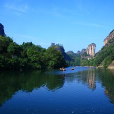
Taining Geology Park is a UNESCO Geopark in Taining County featuring steep cliffs, deep valleys, and layered rock formations shaped by millions of years of geological movement. The park displays multiple valleys, waterways, and stone features that create distinct scenic zones across the landscape.
The park was upgraded from the former Dajinhu National Geopark and approved by UNESCO on 11 February 2005 as one of the second batch of World Geoparks. In 2008 the scenic area, formerly called Jinhu National Scenic Area, was renamed Taining National Scenic Area. It covers 492.5 km², of which 252.7 km² is Danxia landform, alongside volcanic and granite landforms.
The park takes its name from Taining County, and its main scenic area was long called Jinhu, or "Golden Lake", after the Jinhu National Scenic Area. In 2008 that scenic area was renamed the Taining National Scenic Area, matching the geopark's name. The park is divided into five scenic areas: Shangqingxi, Taining Ancient Town, Jinhu, Longwangyan-Baxianya and Jinnaoshan.
The park is reached by train to Taining County from nearby cities, then by local bus to reach different areas and viewpoints. Multiple entry points and trails exist for visitors of different abilities.
The park's 492.5 square kilometres are mostly Danxia landform, 252.7 square kilometres of it, alongside volcanic and granite structures. It was upgraded from the former Dajinhu National Geopark and approved by UNESCO on 11 February 2005 as one of the second batch of world geoparks. Its five scenic areas are Shangqingxi, Taining Old Town, Jinhu, Longwangyan-Baxianya and Jinnaoshan.
The community of curious travelers
AroundUs brings together thousands of curated places, local tips, and hidden gems, enriched daily by 93,607 contributors worldwide.