Enable Location

We need your location to show you interesting places around you

Discover nearby places

Find interesting locations and hidden gems around you

Precise directions

Get accurate directions and distances to places

Your location is never shared with other users. It's only used when you tap the location button.

Amhara Region

Log in to your account

Start exploring — it's free

Trusted by 62,911 travelers worldwide

Continue with Google
Continue with Apple
or

We will send you a code to connect

By continuing, you accept our Terms and Conditions and our Privacy Policy

Check your inbox

We've sent a pincode in your inbox. Please enter the code below.

Discussion Reviews 4 Photos
112k Popularity

Amhara Region, Administrative region in northern Ethiopia

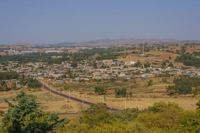
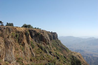
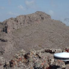
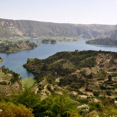
The Amhara region is an administrative division in northern Ethiopia that extends across varied landscapes of mountains, plateaus, and Lake Tana. The territory ranges from the rugged peaks of the Semien range to the fertile plains where rural communities and towns are located.

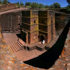
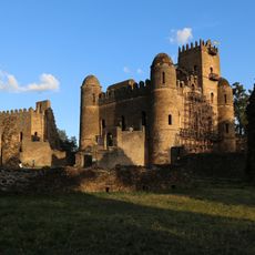
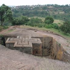
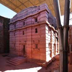
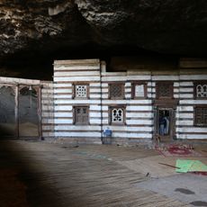
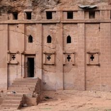
The area played a central role in the Ethiopian Empire from the 13th century, when imperial administration created provinces such as Gojjam and Gondar. In the 12th century, the rock-hewn churches of Lalibela emerged, becoming some of the most important religious sites in the country.

Islands in Lake Tana shelter Orthodox monasteries where monks preserve centuries-old religious texts and icons. Visitors can reach some of these monasteries and witness the living tradition of the Ethiopian Orthodox Church, which has continued here since medieval times.

Most visitors focus on the larger towns and the more accessible sites, while remote rural areas are less easy to reach. Those exploring the mountain areas should be prepared for changing weather conditions and longer travel times between places.

Lalibela contains eleven churches carved from solid rock, connected to each other through underground tunnels and passages. The builders worked from top to bottom, shaping each church from a single block of stone so that walls, roofs, and columns flow seamlessly together.

The community of curious travelers

AroundUs brings together thousands of curated places, local tips, and hidden gems, enriched daily by 60,000 contributors worldwide.

Start exploring
Location
Inception
1992
Capital city
Bahir Dar
Reference
03
Shares border with
Tigray Region, Afar Region, Oromia Region, Benishangul-Gumuz Region
GPS coordinates
11.66080,37.95780
Latest update
December 14, 2025 23:49
Reviews
Share your experience

No review yet

Discussions
Start a discussion...

No discussion yet

« Amhara Region - Administrative region in northern Ethiopia » is provided by Around Us (aroundus.com). Images and texts are derived from Wikimedia project under a Creative Commons license. You are allowed to copy, distribute, and modify copies of this page, under the conditions set by the license, as long as this note is clearly visible.

Discover hidden gems everywhere you go!

From secret cafés to breathtaking viewpoints, skip the crowded tourist spots and find places that match your style. Our app makes it easy with voice search, smart filtering, route optimization, and insider tips from travelers worldwide. Download now for the complete mobile experience.

Around Us App Screenshot

A unique approach to discovering new places

Le Figaro

All the places worth exploring

France Info

A tailor-made excursion in just a few clicks

20 Minutes

Around Us
Travel Guide & Maps
Download

Send to your phone

QR Code
1

Open the camera app on your mobile.

2

Point at the QR code with your camera. A notification will appear.

3

Tap the notification to open the link.