Enable Location

We need your location to show you interesting places around you

Discover nearby places

Find interesting locations and hidden gems around you

Precise directions

Get accurate directions and distances to places

Your location is never shared with other users. It's only used when you tap the location button.

St Catherine's Church, Boot

Log in to your account

Start exploring — it's free

Trusted by 61,458 travelers worldwide

Continue with Google
Continue with Apple
or

We will send you a code to connect

By continuing, you accept our Terms and Conditions and our Privacy Policy

Check your inbox

We've sent a pincode in your inbox. Please enter the code below.

St Catherine's Church, Boot

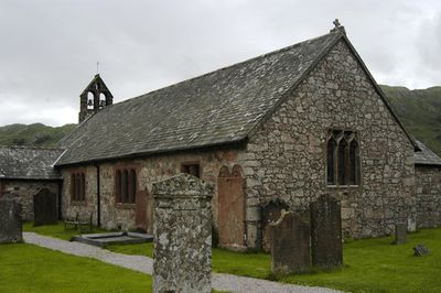
St Catherine's Church, Boot, Gothic parish church in Boot, England

Description

St Catherine's Church is a Gothic parish church built with random rubble stone walls, a slate roof, and a distinctive double bellcote positioned at the western end. The structure displays the construction techniques typical of English medieval church building.

History

The site has origins dating to the 6th century, though the structure standing today was built during the 14th century. Major restoration work by Paley and Austin architects in 1881 brought the building to its current condition.

Culture

The interior holds an octagonal font carved with detailed relief work and stained glass windows from 1889 showing religious scenes. These pieces reflect the artistic tastes that shaped the community's spiritual space over the centuries.

Practical

The grounds provide level pathways and are easy to navigate for visitors of different mobility levels. Parking is available within short walking distance, and the location sits just a brief walk from Dalegarth Station terminal.

Did you know?

One of the bells in the bellcote was cast in 1445, linking modern visitors directly to medieval bell-making craft. This ancient piece is a rare survival from that period of church history.

Location
Architects
Sharpe, Paley and Austin
Architectural style
English Gothic architecture
GPS coordinates
54.39110,-3.27060
Latest update
December 14, 2025 18:44

AroundUs brings together thousands of curated places, local tips, and hidden gems, enriched daily by 60,000 contributors worldwide. Discover all places nearby (Eskdale).

Around this place
Hardknott Roman Fort
United Kingdom

Hardknott Roman Fort

4.6 km
Harter Fell
United Kingdom

Harter Fell

4.3 km
Cairnfield including a prehistoric enclosure, 5 stone circles, 10 funerary cairns, 6 stone banks, 2 stone walls, a lynchet and a
United Kingdom

Cairnfield including a prehistoric enclosure, 5 stone circles, 10 funerary cairns, 6 stone banks, 2 stone walls, a lynchet and a

2.3 km
Illgill Head
United Kingdom

Illgill Head

4.7 km
Slight Side
United Kingdom

Slight Side

5.8 km
Birks Bridge
United Kingdom

Birks Bridge

5.9 km
Green Crag
United Kingdom

Green Crag

3.1 km
Eskdale Centre
United Kingdom

Eskdale Centre

3.2 km
St Bega's Church
United Kingdom

St Bega's Church

3.4 km
Church of St Michael and All Angels
United Kingdom

Church of St Michael and All Angels

6.4 km
Eskdale Mill
United Kingdom

Eskdale Mill

895 m
Bridge Over Whillan Beck To South West Of Corn Mill
United Kingdom

Bridge Over Whillan Beck To South West Of Corn Mill

869 m
Doctor Bridge
United Kingdom

Doctor Bridge

1.4 km
Eskdale War Memorial
United Kingdom

Eskdale War Memorial

549 m
Barn West Of Forge House
United Kingdom

Barn West Of Forge House

3.1 km
K6 Telephone Kiosk
United Kingdom

K6 Telephone Kiosk

3.7 km
Bridge End Farmhouse
United Kingdom

Bridge End Farmhouse

834 m
Forge House With Attached Barn, Stable And Byres
United Kingdom

Forge House With Attached Barn, Stable And Byres

3.1 km
Boot House And Whillanside
United Kingdom

Boot House And Whillanside

857 m
Dalegarth Hall
United Kingdom

Dalegarth Hall

604 m
Building To South West Of Corn Mill On East Side Of Road At North End Of Bridge
United Kingdom

Building To South West Of Corn Mill On East Side Of Road At North End Of Bridge

878 m
Barn To North West Of Bridge End Farmhouse
United Kingdom

Barn To North West Of Bridge End Farmhouse

840 m
Barn To South West Of Whillanside
United Kingdom

Barn To South West Of Whillanside

841 m
Great Crag prehistoric cairnfield and associated field system 710m south east of Birkerthwaite
United Kingdom

Great Crag prehistoric cairnfield and associated field system 710m south east of Birkerthwaite

2.7 km
Prehistoric cairnfield, associated field system and hut circle      east of Water Crag
United Kingdom

Prehistoric cairnfield, associated field system and hut circle east of Water Crag

3.5 km
Prehistoric enclosure, hut circle and adjacent cairnfield east of Whillan Beck, Burnmoor
United Kingdom

Prehistoric enclosure, hut circle and adjacent cairnfield east of Whillan Beck, Burnmoor

3.3 km
Maiden Castle round cairn, Burnmoor
United Kingdom

Maiden Castle round cairn, Burnmoor

5.2 km
Eskdale Corn Mill
United Kingdom

Eskdale Corn Mill

891 m
Show the full map
« St Catherine's Church, Boot - Gothic parish church in Boot, England » is provided by Around Us (aroundus.com). Images and texts are derived from Wikimedia project under a Creative Commons license. You are allowed to copy, distribute, and modify copies of this page, under the conditions set by the license, as long as this note is clearly visible.

Discover hidden gems everywhere you go!

From secret cafés to breathtaking viewpoints, skip the crowded tourist spots and find places that match your style. Our app makes it easy with voice search, smart filtering, route optimization, and insider tips from travelers worldwide. Download now for the complete mobile experience.

Around Us App Screenshot

A unique approach to discovering new places

Le Figaro

All the places worth exploring

France Info

A tailor-made excursion in just a few clicks

20 Minutes

Around Us
Travel Guide & Maps
Download

Send to your phone

QR Code
1

Open the camera app on your mobile.

2

Point at the QR code with your camera. A notification will appear.

3

Tap the notification to open the link.